Shepway District
Located in Kent, England Coordinates: 51°04′54″ N 1°09′14″ E
- Population
- 111,190
- 111.2K
- Elevation
- 54 m
- above sea level
- Local time
- UTC+00:00
- Europe/London · UTC+00:00
- Places inside
- 30
- listed under Shepway District
About Shepway District
Shepway District is a municipality. Location: Kent, England. Population: 111,190. Elevation: 54 m.
In comparison
- No. 13 of 17 places in Kent by population
- Nearest larger town: Dover District, 9 km NE
- 28 sights and natural places within 10 km Sandgate Castle, Kingsworth Gardens
- Listed here: Village: 30
Places in Shepway District
30 places-
Acrise Village
-
Brenzett Village
-
Brookland Village
-
Burmarsh Village
-
Dymchurch Village
-
Elham Village
-
Elmsted Village
-
Folkestone Village
-
Hawkinge Village
-
Hythe Village
-
Ivychurch Village
-
Lydd Village
-
Lyminge Village
-
Lympne Village
-
Monks Horton Village
-
Newchurch Village
-
Newington Village
-
New Romney Village
-
Old Romney Village
-
Paddlesworth Village
-
Postling Village
-
Saltwood Village
-
Sandgate Village
-
Sellindge Village
-
Snargate Village
-
Stanford Village
-
Stelling Minnis Village
-
St. Mary in the Marsh Village
-
Stowting Village
-
Swingfield Village
Nearby attractions & nature
Everything nearby-
Folkestone Lighthouse Landmark, Kent2.9 km E
-
Swinge Hill Mountain, Capel-le-Ferne4.1 km NE
-
Oaklands Park Natural site, Kent5.1 km W
-
East Wear Bay Natural site, Kent4.8 km E
-
Brookhill Country Park Natural site, Kent6.2 km W
-
Folkestone Mediumwave Transmitter, Mast North Landmark, Capel-le-Ferne5.3 km NE
-
Folkestone Mediumwave Transmitter, Mast South Landmark, Capel-le-Ferne5.4 km NE
-
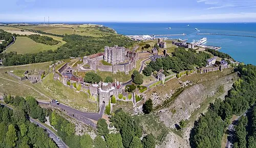 Dover Castle Historic site, Dover13 km NE
Other cities and towns in Kent
-
Folkestone Town, Folkestone0.9 km E
-
Hawkinge Town, Hawkinge3.5 km N
-
Hythe Town, Hythe5 km W
-
City of Canterbury Municipality, Kent23 km N
-
Ashford Municipality, Kent25 km W
-
 Canterbury Town, City of Canterbury23 km N
Sources & licences
Data last updated: