Weeting Castle
Located in Weeting-with-Broomhill, Breckland District Coordinates: 52°28′16″ N 0°36′58″ E
- Local time
- UTC+00:00
- Europe/London · UTC+00:00
- Elevation
- 10 m
- above sea level
- Airports
- NWI Norwich Airport51 km
- STN London Stansted Airport70 km
About Weeting Castle
Weeting Castle is a historic site. Location: Weeting-with-Broomhill, Breckland District.
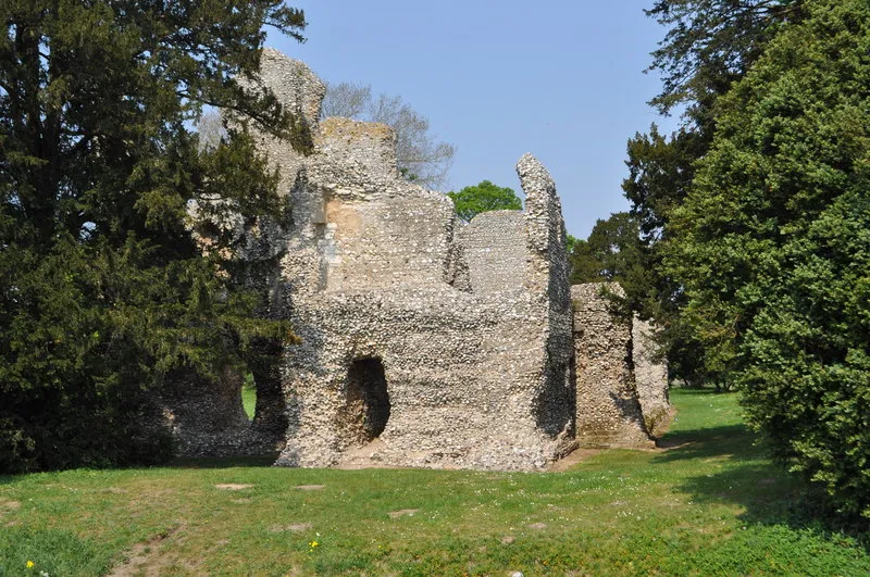
Weeting Castle is a ruined, medieval manor house near the village of Weeting in Norfolk, England. It was built around 1180 by Hugh de Plais, and comprised a three-storey tower, a substantial hall, and a service block, with a separate kitchen positioned near the house. A moat was later dug around the site in the 13th century. The house was not fortified, although it drew on architectural features typically found in castles of the period, and instead formed a very large, high-status domestic dwelling.
Source: Wikipedia · CC BY-SA 4.0
Photos of Weeting Castle
-

Peter S · CC BY-SA 2.0 -

Oxyman · CC BY 2.5 -

Keith Evans · CC BY-SA 2.0


Climate of Weeting Castle
Best months for sightseeingBest months for sightseeing: June–August.
This month · November
A cold month
Day 10° · Night 4° · Rain 63 mm
- Hottest month
- July (day 22°)
- Coldest month
- February (night 1°)
- Wettest month
- November (63 mm)
- Driest month
- February (37 mm)
Bars: average monthly low and high temperature. Below: precipitation. Monthly averages for 1970–2000 at about 18 km resolution, adjusted for elevation. Highlighted months are mild and relatively dry. Source: WorldClim 2.1 (CC BY 4.0).
Show values as a table
| Month | Jan | Feb | Mar | Apr | May | Jun | Jul | Aug | Sep | Oct | Nov | Dec |
|---|---|---|---|---|---|---|---|---|---|---|---|---|
| Average high (°C) | 7° | 7° | 10° | 12° | 16° | 20° | 22° | 22° | 19° | 15° | 10° | 8° |
| Average low (°C) | 2° | 1° | 3° | 4° | 7° | 10° | 12° | 12° | 10° | 7° | 4° | 3° |
| Precipitation (mm) | 54 | 37 | 48 | 46 | 44 | 58 | 49 | 51 | 56 | 56 | 63 | 56 |
How to get to Weeting Castle
The nearest airport is Norwich Airport (NWI), 51 km to the northeast as the crow flies. For international flights: London Stansted Airport (STN) (70 km). The nearest large city is Cambridge, 45 km to the southwest.
Airports
- Norwich Airport (NWI) Norwich, Norfolk 51 kmnortheast
- London Stansted Airport (STN) London, Essex 70 kmsouth
- London Luton Airport (LTN) Luton, Luton 95 kmsouthwest
Nearby large cities
- Cambridge Population: 145.7K 45 kmsouthwest
- Norwich Population: 143.1K 49 kmeast
- Ipswich Population: 178.8K 59 kmsoutheast
- Peterborough Population: 163.4K 60 kmwest
- Colchester Population: 130.2K 68 kmsouth
Straight-line distances; road distances are longer. Airport data: OurAirports.
Day trips from Weeting Castle
Within 100 km: 418 historic and cultural sites, 151 natural sites, 166 lakes, rivers and coasts.
0–25 km40 places
- Dog Island Island 16 kmSE
- Long Island Island 16 kmSE
- Butten Island Island 11 kmSE
- Birdcage Island Island 8 kmN
25–60 km212 places
- Snettisham Beach Beach 46 kmN
- Scolt Head Island Island 58 kmN
- Warham Salt Marsh - West Island 59 kmN
- Lodge Marsh Island 59 kmN
60–100 km483 places
- Weybourne Beach Beach 64 kmNE
- Sheringham Beach Beach 66 kmNE
- Hemsby Beach Beach 78 kmE
- Aldeburgh's Beach Beach 76 kmSE
Straight-line distances.
Nearby attractions & nature
Everything nearby-
Thetford Forest Park Natural site, Lynford3.9 km E
-
Stanton Downham Park Natural site, Santon Downham4.1 km SE
-
St Andrew and St Patrick Attraction, Elveden10 km SE
-
Thetford Red Castle Historic site, Thetford10 km SE
-
Thetford Priory Historic site, Thetford11 km SE
-
Thetford Castle Hill Historic site, Thetford12 km SE
-
Freckenham Castle Historic site, Freckenham21 km SW
-
Marham Castle Historic site, Marham22 km N
Nearest towns and villages
-
Weeting Village, Weeting-with-Broomhill0.7 km S
-
Fengate Neighbourhood, Weeting-with-Broomhill1.3 km S
-
Mundford Village, Mundford4.8 km NE
-
Hockwold cum Wilton Village, Hockwold cum Wilton4.8 km W
Sources & licences
Data last updated: · 2 independent sources