Swinithwaite
Located in West Witton, Richmondshire District Coordinates: 54°17′53″ N 1°56′06″ W
- Elevation
- 178 m
- above sea level
- Local time
- UTC+00:00
- Europe/London · UTC+00:00
- Airports
- MME Teesside International Airport40 km
- LBA Leeds Bradford Airport51 km
About Swinithwaite
Swinithwaite is a village. Location: West Witton, Richmondshire District. Elevation: 178 m. The best months to visit are June–August. The nearest airport is Teesside International Airport (40 km). Nearby sights include Bolton Castle and Batt Island.
Photos of Swinithwaite
-
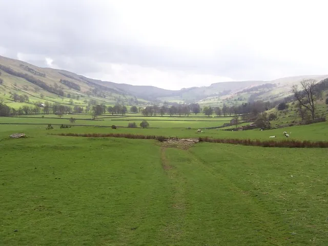
Bishopdale Chris Heaton · CC BY-SA 2.0 -
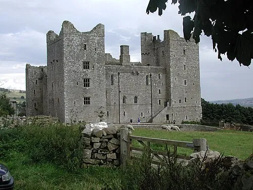
Bolton Castle Bob Weyker · CC BY-SA 3.0


Climate of Swinithwaite
Best months for sightseeingBest months for sightseeing: June–August.
This month · November
A wet month
Day 9° · Night 4° · Rain 138 mm
- Hottest month
- July (day 19°)
- Coldest month
- January (night 1°)
- Wettest month
- December (142 mm)
- Driest month
- May (82 mm)
Bars: average monthly low and high temperature. Below: precipitation. Monthly averages for 1970–2000 at about 18 km resolution, adjusted for elevation. Highlighted months are mild and relatively dry. Source: WorldClim 2.1 (CC BY 4.0).
Show values as a table
| Month | Jan | Feb | Mar | Apr | May | Jun | Jul | Aug | Sep | Oct | Nov | Dec |
|---|---|---|---|---|---|---|---|---|---|---|---|---|
| Average high (°C) | 6° | 6° | 8° | 11° | 14° | 17° | 19° | 19° | 16° | 12° | 9° | 7° |
| Average low (°C) | 1° | 1° | 2° | 3° | 6° | 9° | 11° | 11° | 9° | 6° | 4° | 2° |
| Precipitation (mm) | 139 | 98 | 110 | 84 | 82 | 86 | 92 | 112 | 116 | 131 | 138 | 142 |
How to get to Swinithwaite
The nearest airport is Teesside International Airport (MME), 40 km to the northeast as the crow flies. For international flights: Leeds Bradford Airport (LBA) (51 km). The nearest large city is Middlesbrough, 55 km to the northeast.
Airports
- Teesside International Airport (MME) Darlington, Durham 40 kmnortheast
- Leeds Bradford Airport (LBA) Leeds, West Yorkshire 51 kmsouth
- Newcastle International Airport (NCL) Newcastle upon Tyne, Tyne and Wear 84 kmnorth
Nearby large cities
- Middlesbrough Population: 142.7K 55 kmnortheast
- Bradford Population: 366.2K 57 kmsouth
- Burnley Population: 149.4K 59 kmsouth
- Leeds Population: 536.3K 61 kmsoutheast
- York Population: 156.1K 67 kmsoutheast
Straight-line distances; road distances are longer. Airport data: OurAirports.
Day trips from Swinithwaite
Within 100 km: 877 historic and cultural sites, 1,828 natural sites, 308 lakes, rivers and coasts.
0–25 km126 places
- The Island Island 19 kmE
- Batt Island Island 2 kmE
- Semer Water Lake 12 kmW
- Leighton Reservoir Lake 15 kmSE
25–60 km800 places
- Great Britain Island 33 kmS
- Bird Island Island 46 kmSW
- The Island Island 38 kmSE
- The Island Island 54 kmSE
60–100 km2,087 places
- High Moor Mountain 79 kmW
- St Anne's Beach Beach 95 kmSW
- Roanhead Beach Beach 87 kmW
- Seaton Carew Beach Beach 63 kmNE
Straight-line distances.
Nearby attractions & nature
Everything nearby-
Bolton Castle Historic site, Castle Bolton with East and West Bolton2.8 km N
-
Batt Island Island, Redmire1.8 km E
-
West Witton Penhill Beacon Landmark, West Witton2.7 km SE
-
Walden Beck River, England2.1 km W
-
Penhill Beacon Mountain, Carlton Town3.5 km S
-
Height of Hazely Mountain, Burton-cum-Walden3.3 km S
Sources & licences
Data last updated: