Hutton Village
Located in Guisborough, Redcar and Cleveland Coordinates: 54°30′58″ N 1°04′19″ W
- Elevation
- 153 m
- above sea level
- Local time
- UTC+00:00
- Europe/London · UTC+00:00
- Airports
- MME Teesside International Airport23 km
- NCL Newcastle International Airport70 km
About Hutton Village
Hutton Village is a village. Location: Guisborough, Redcar and Cleveland. Elevation: 153 m.
Hutton Village is a settlement in the Hutton Lowcross area of Guisborough in North Yorkshire, England. Whilst the area itself is mentioned in the Domesday Book, the village was built largely due to the development of the ironstone industry in the Cleveland Hills. The name Hutton Lowcross referred to the township in the area, whereas the settlement is now known as Hutton Village. The village is set in a narrow dale that carries Hutton Beck northwards towards Guisborough.
Source: Wikipedia · CC BY-SA 4.0
Photos of Hutton Village
-
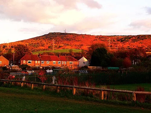
Eston Nab Francis Hannaway · CC BY-SA 3.0

Climate of Hutton Village
Best months for sightseeingBest months for sightseeing: June–August.
This month · November
A cold month
Day 9° · Night 3° · Rain 82 mm
- Hottest month
- July (day 19°)
- Coldest month
- January (night 1°)
- Wettest month
- November (82 mm)
- Driest month
- April (47 mm)
Bars: average monthly low and high temperature. Below: precipitation. Monthly averages for 1970–2000 at about 18 km resolution, adjusted for elevation. Highlighted months are mild and relatively dry. Source: WorldClim 2.1 (CC BY 4.0).
Show values as a table
| Month | Jan | Feb | Mar | Apr | May | Jun | Jul | Aug | Sep | Oct | Nov | Dec |
|---|---|---|---|---|---|---|---|---|---|---|---|---|
| Average high (°C) | 6° | 6° | 8° | 11° | 14° | 17° | 19° | 19° | 16° | 12° | 9° | 7° |
| Average low (°C) | 1° | 1° | 2° | 3° | 5° | 8° | 10° | 10° | 8° | 6° | 3° | 1° |
| Precipitation (mm) | 79 | 54 | 62 | 47 | 53 | 58 | 61 | 69 | 72 | 81 | 82 | 79 |
How to get to Hutton Village
The nearest airport is Teesside International Airport (MME), 23 km to the west as the crow flies. For international flights: Newcastle International Airport (NCL) (70 km). The nearest large city is Middlesbrough, 12 km to the northwest.
Airports
- Teesside International Airport (MME) Darlington, Durham 23 kmwest
- Newcastle International Airport (NCL) Newcastle upon Tyne, Tyne and Wear 70 kmnorthwest
- Leeds Bradford Airport (LBA) Leeds, West Yorkshire 82 kmsouthwest
Nearby large cities
- Middlesbrough Population: 142.7K 12 kmnorthwest
- Sunderland Population: 170.1K 48 kmnorthwest
- Newcastle upon Tyne Population: 300.1K 62 kmnorthwest
- York Population: 156.1K 62 kmsouth
- Leeds Population: 536.3K 86 kmsouth
Straight-line distances; road distances are longer. Airport data: OurAirports.
Day trips from Hutton Village
Within 100 km: 491 historic and cultural sites, 614 natural sites, 146 lakes, rivers and coasts.
0–25 km97 places
- Seaton Carew Beach Beach 18 kmNW
- Redcar Beach Beach 12 kmN
- St Thomas's Island Island 22 kmSE
- Roseberry Topping Mountain 3 kmSW
25–60 km337 places
- Whitby Beach Beach 28 kmE
- The Island Island 49 kmSW
- Peasholm Island Island 50 kmSE
- The Island Island 53 kmSW
60–100 km817 places
- Great Britain Island 83 kmSW
- North Beach Beach 75 kmSE
- Fraisethorpe Beach Beach 76 kmSE
- Saint Mary’s Island Island 66 kmN
Straight-line distances.
Nearby attractions & nature
Everything nearby-
Great Ayton Moor Mountain, Guisborough1.4 km S
-
Gisborough Moor Mountain, Guisborough3.4 km SE
-
Roseberry Topping Mountain, Great Ayton2.6 km SW
-
Eston Nab Mountain, Guisborough5.6 km NW
-
Cliff Rigg Mountain, Great Ayton3.5 km SW
-
Easby Moor Mountain, Easby3.9 km S
Sources & licences
Data last updated: · 2 independent sources