- Elevation
- 195 m
- above sea level
- Local time
- UTC+00:00
- Europe/London · UTC+00:00
- Airports
- BHX Birmingham Airport80 km
- LPL Liverpool John Lennon Airport94 km
About Choulton
Choulton is a village. Location: Lydbury North, Shropshire. Elevation: 195 m. The best months to visit are June–August. The nearest airport is Birmingham Airport (80 km). Nearby sights include Billings Ring and Plowden Mill.
Photos of Choulton
-
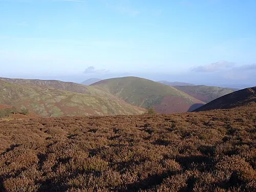
Long Mynd - Pole Bank Own Herby talk thyme · CC BY-SA 4.0

Climate of Choulton
Best months for sightseeingBest months for sightseeing: June–August.
This month · November
A cold month
Day 9° · Night 3° · Rain 93 mm
- Hottest month
- July (day 20°)
- Coldest month
- February (night 1°)
- Wettest month
- January (101 mm)
- Driest month
- July (55 mm)
Bars: average monthly low and high temperature. Below: precipitation. Monthly averages for 1970–2000 at about 18 km resolution, adjusted for elevation. Highlighted months are mild and relatively dry. Source: WorldClim 2.1 (CC BY 4.0).
Show values as a table
| Month | Jan | Feb | Mar | Apr | May | Jun | Jul | Aug | Sep | Oct | Nov | Dec |
|---|---|---|---|---|---|---|---|---|---|---|---|---|
| Average high (°C) | 6° | 6° | 9° | 12° | 15° | 18° | 20° | 20° | 17° | 13° | 9° | 7° |
| Average low (°C) | 1° | 1° | 2° | 3° | 6° | 9° | 11° | 10° | 8° | 6° | 3° | 2° |
| Precipitation (mm) | 101 | 72 | 77 | 61 | 59 | 67 | 55 | 72 | 79 | 87 | 93 | 101 |
How to get to Choulton
The nearest airport is Birmingham Airport (BHX), 80 km to the east as the crow flies. The nearest large city is Telford, 38 km to the northeast.
Airports
- Birmingham Airport (BHX) Birmingham, West Midlands 80 kmeast
- Liverpool John Lennon Airport (LPL) Liverpool 94 kmnorth
- Manchester Airport (MAN) Manchester, Greater Manchester 105 kmnortheast
Nearby large cities
- Telford Population: 155.6K 38 kmnortheast
- Wolverhampton Population: 263.7K 55 kmeast
- Dudley Population: 199.1K 57 kmeast
- Worcester Population: 101.7K 58 kmsoutheast
- West Bromwich Population: 103.1K 63 kmeast
Straight-line distances; road distances are longer. Airport data: OurAirports.
Day trips from Choulton
Within 100 km: 953 historic and cultural sites, 2,588 natural sites, 169 lakes, rivers and coasts.
0–25 km354 places
- Reservoir Lake 23 kmNE
- Titterstone Clee Hill Mountain 24 kmSE
- Brown Clee Hill Mountain 22 kmE
- Beacon Hill Mountain 23 kmSW
25–60 km1,253 places
- The Island Island 28 kmSE
- Bevere Island Island 54 kmSE
- Withymoor Island Island 57 kmE
- Lake Vyrnwy Lake 52 kmNW
60–100 km2,103 places
- Thurstaston Beach Beach 96 kmN
- Ynys Tywyn Island 95 kmNW
- Ynys Gifftan Island 92 kmNW
- Alney Island Island 83 kmSE
Straight-line distances.
Nearby attractions & nature
Everything nearby-
Billings Ring Mountain, Lydbury North0.8 km W
-
Plowden Mill Historic site, Lydbury North1.4 km SE
-
Lynchgate Hill Mountain, Lydbury North1.8 km S
-
Lea Castle Historic site, Lydham2.8 km W
-
Oakeley Mynd Mountain, Lydbury North3 km W
-
Hardwick Historic site, Norbury2.5 km NW
Sources & licences
Data last updated: