- Population
- 1,901
- 1.9K
- Elevation
- 49 m
- above sea level
- Local time
- UTC+00:00
- Europe/London · UTC+00:00
- Airports
- MAN Manchester Airport8 km
- LPL Liverpool John Lennon Airport44 km
About Cheadle Heath
Cheadle Heath is a neighbourhood. Location: Stockport, England. Population: 1,901.
Cheadle Heath is a suburb of Stockport, Greater Manchester, England, 2 miles (3.2 km) west of the town centre and 8 miles (13 km) southeast of Manchester. Cheadle Heath railway station, on the site now occupied by Morrisons supermarket, closed in 1967. It is home to Cheadle Heath Nomads Football Club.
Source: Wikipedia · CC BY-SA 4.0
At a glance
- Area
- 3 km²
Source: Wikidata
Climate of Cheadle Heath
Best months for sightseeingBest months for sightseeing: June–August.
This month · November
A cold month
Day 10° · Night 4° · Rain 86 mm
- Hottest month
- July (day 21°)
- Coldest month
- January (night 2°)
- Wettest month
- October (87 mm)
- Driest month
- April (52 mm)
Bars: average monthly low and high temperature. Below: precipitation. Monthly averages for 1970–2000 at about 18 km resolution, adjusted for elevation. Highlighted months are mild and relatively dry. Source: WorldClim 2.1 (CC BY 4.0).
Show values as a table
| Month | Jan | Feb | Mar | Apr | May | Jun | Jul | Aug | Sep | Oct | Nov | Dec |
|---|---|---|---|---|---|---|---|---|---|---|---|---|
| Average high (°C) | 7° | 7° | 10° | 12° | 16° | 19° | 21° | 21° | 17° | 14° | 10° | 8° |
| Average low (°C) | 2° | 2° | 3° | 5° | 8° | 11° | 13° | 12° | 10° | 7° | 4° | 3° |
| Precipitation (mm) | 76 | 54 | 64 | 52 | 53 | 67 | 60 | 74 | 72 | 87 | 86 | 83 |
How to get to Cheadle Heath
The nearest airport is Manchester Airport (MAN), 8 km to the southwest as the crow flies. The nearest large city is Stockport, 2 km to the east.
Airports
- Manchester Airport (MAN) Manchester, Greater Manchester 8 kmsouthwest
- Liverpool John Lennon Airport (LPL) Liverpool 44 kmwest
- Leeds Bradford Airport (LBA) Leeds, West Yorkshire 62 kmnortheast
Nearby large cities
- Stockport Population: 139.1K 2 kmeast
- Manchester Population: 569K 9 kmnorth
- Salford Population: 129.8K 12 kmnorthwest
- Oldham Population: 237.1K 16 kmnorth
- Bolton Population: 141.3K 26 kmnorthwest
Straight-line distances; road distances are longer. Airport data: OurAirports.
Day trips from Cheadle Heath
Within 100 km: 699 historic and cultural sites, 1,176 natural sites, 192 lakes, rivers and coasts.
0–25 km158 places
- Saint George's Island Island 9 kmNW
- Birch Island Island 16 kmSW
- Woodhead Reservoir Lake 23 kmNE
- Valehouse Reservoir Lake 18 kmNE
25–60 km658 places
- The Island Island 34 kmNW
- Don Island Island 55 kmE
- Calder Island Island 54 kmNE
- Stennard Island Island 56 kmNE
60–100 km1,251 places
- Great Britain Island 68 kmN
- Thurstaston Beach Beach 64 kmW
- Formby Beach Beach 63 kmW
- Ainsdale Beach Beach 62 kmW
Straight-line distances.
Nearby attractions & nature
Everything nearby-
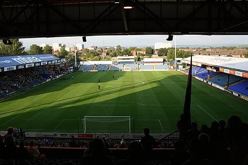 Edgeley Park Landmark, Offerton Park1.6 km E
-
Stockport Castle Historic site, Stockport2.5 km NE
-
Peel Moat Landmark, Stockport3 km N
-
River Goyt River, England3.2 km NE
-
Norbury Church Attraction, Stockport5.7 km SE
-
 Old Trafford Landmark, Trafford9.5 km NW
Sources & licences
Data last updated: · 2 independent sources