Long Ditton
Located in Elmbridge District, Surrey Coordinates: 51°23′04″ N 0°19′13″ W
- Population
- 6,343
- 6.3K
- Elevation
- 16 m
- above sea level
- Local time
- UTC+00:00
- Europe/London · UTC+00:00
About Long Ditton
Long Ditton is a town. Location: Elmbridge District, Surrey. Population: 6,343. Elevation: 16 m.
In comparison
- No. 9 of 13 places in Elmbridge District by population
- Nearest larger town: Surbiton, 2 km NE
- 83 sights and natural places within 10 km Boyle Farm Island, Thames Ditton Island
Nearby attractions & nature
Everything nearby-
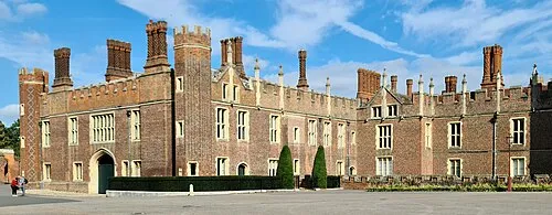 Hampton Court Palace Historic site, Richmond upon Thames2.4 km NW
-
Boyle Farm Island Island, Elmbridge District1.1 km NW
-
Thames Ditton Island Island, Elmbridge District1.3 km NW
-
Ravens Ait Island, Kingston upon Thames1.7 km N
-
 Kingsmeadow Landmark, Kingston upon Thames3.5 km NE
-
Hampton Court Park (Home Park) Natural site, Richmond upon Thames2.4 km N
-
Chessington Castle Hill Historic site, Kingston upon Thames3.6 km SE
-
The Lake Lake, Elmbridge District3.9 km SW
Other cities and towns in Elmbridge District
Sources & licences
Data last updated: