Ballywhite Hill
Located in Ards and North Down, Northern Ireland Coordinates: 54°23′54″ N 5°33′53″ W
- Elevation
- 101 m
- above sea level
- Local time
- UTC+00:00
- Europe/London · UTC+00:00
- Airports
- BHD George Best Belfast City Airport32 km
- BFS Belfast International Airport51 km
About Ballywhite Hill
Ballywhite Hill is a mountain. Location: Ards and North Down, Northern Ireland. Elevation: 101 m. The best months to visit are June–August. The nearest airport is George Best Belfast City Airport (32 km). Nearby sights include Ballyherly Lough and Lough Cowey.
Photos of Ballywhite Hill
-
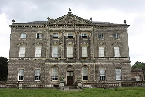
Castle Ward Ardfern · CC BY-SA 3.0

Climate of Ballywhite Hill
Best months for sightseeingBest months for sightseeing: June–August.
This month · November
A cold month
Day 8° · Night 2° · Rain 70 mm
- Hottest month
- July (day 20°)
- Coldest month
- January (night 0°)
- Wettest month
- January (78 mm)
- Driest month
- May (50 mm)
Bars: average monthly low and high temperature. Below: precipitation. Monthly averages for 1970–2000 at about 18 km resolution, adjusted for elevation. Highlighted months are mild and relatively dry. Source: WorldClim 2.1 (CC BY 4.0).
Show values as a table
| Month | Jan | Feb | Mar | Apr | May | Jun | Jul | Aug | Sep | Oct | Nov | Dec |
|---|---|---|---|---|---|---|---|---|---|---|---|---|
| Average high (°C) | 5° | 7° | 9° | 12° | 15° | 18° | 20° | 19° | 16° | 12° | 8° | 6° |
| Average low (°C) | 0° | 0° | 2° | 3° | 6° | 9° | 11° | 10° | 8° | 5° | 2° | 0° |
| Precipitation (mm) | 78 | 57 | 60 | 52 | 50 | 56 | 55 | 72 | 68 | 78 | 70 | 78 |
How to get to Ballywhite Hill
The nearest airport is George Best Belfast City Airport (BHD), 32 km to the northwest as the crow flies. For international flights: Belfast International Airport (BFS) (51 km). The nearest large city is Belfast, 32 km to the northwest.
Airports
- George Best Belfast City Airport (BHD) Belfast 32 kmnorthwest
- Belfast International Airport (BFS) Belfast 51 kmnorthwest
- Isle of Man Airport (IOM) Castletown, Rushen 71 kmsoutheast
Nearby large cities
- Belfast Population: 348K 32 kmnorthwest
- Dublin Population: 1M 127 kmsouth
- Blackpool Population: 145K 177 kmeast
- Glasgow Population: 626.4K 183 kmnortheast
- Preston Population: 313.3K 200 kmeast
Straight-line distances; road distances are longer. Airport data: OurAirports.
Day trips from Ballywhite Hill
Within 100 km: 57 historic and cultural sites, 445 natural sites, 264 lakes, rivers and coasts.
0–25 km29 places
- Reagh Island Island 13 kmNW
- Guns Island Island 12 kmS
- Burial Island Island 14 kmNE
- Castle Island Island 8 kmSW
25–60 km219 places
- Rams Island Island 52 kmNW
- Lighthouse Island Island 33 kmN
- East Maiden Island 60 kmN
- Copeland Island Island 31 kmN
60–100 km518 places
- Rockabill Island 94 kmS
- West Maiden Island 60 kmN
- Sheep Island Island 99 kmN
- Sanda Island Island 98 kmN
Straight-line distances.
Nearest towns and villages
-
 Portaferry Village, Ards and North Down2.3 km SE
-
Killyleagh Village, Newry Mourne and Down5.4 km W
-
Strangford Village, Newry Mourne and Down3.2 km S
-
Ardkeen Village, Ards and North Down4.4 km NE
-
Bar Hall Village, Ards and North Down5.2 km SE
-
Kircubbin Village, Ards and North Down10 km N
Nearby attractions & nature
Everything nearby-
Ballyherly Lough Lake, Ards and North Down1.4 km E
-
Lough Cowey Lake, Ards and North Down2.2 km NE
-
Castle Ward Historic site, Newry Mourne and Down3 km S
-
Castlemahon Mountain Mountain, Newry Mourne and Down6.1 km SW
-
Salt Island Island, Newry Mourne and Down5.7 km SW
-
Cloghy Bay Natural site, Northern Ireland7 km NE
-
Gores Island Island, Newry Mourne and Down7.1 km SW
-
Mahee Island Island, Ards and North Down12 km N
Sources & licences
Data last updated: