Strabane
Located in Derry City and Strabane, Northern Ireland Coordinates: 54°49′25″ N 7°28′09″ W
- Population
- 14,198
- 14.2K
- Elevation
- 7 m
- above sea level
- Local time
- UTC+00:00
- Europe/London · UTC+00:00
- Airports
- LDY City of Derry Airport31 km
- CFN Donegal Airport61 km
About Strabane
Strabane is a city. Location: Derry City and Strabane, Northern Ireland. Population: 14,198. Elevation: 7 m.
Strabane (; from Irish An Srath Bán, meaning 'the white river-holm') is a town in County Tyrone, Northern Ireland. Strabane had a population of 13,507 at the 2021 census. It lies on the east bank of the River Foyle. It is roughly midway from Omagh, Derry and Letterkenny. The River Foyle marks the border between Northern Ireland and the Republic of Ireland. On the other side of the river (across Lifford Bridge) is the smaller town of Lifford, which is the county town of Donegal.
Source: Wikipedia · CC BY-SA 4.0
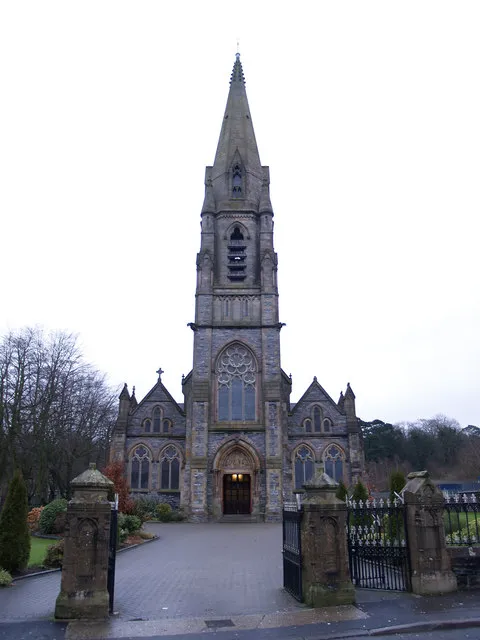
Photos of Strabane
-

henrikjon · CC BY-SA 2.0

Travel notes for Strabane
From Wikivoyage
Strabane is a town in County Tyrone in Northern Ireland. It's an economically depressed market town with a population in 2021 of 13,500. It stands on the east bank of the River Foyle, which forms the border with the Republic of Ireland. Over on the west bank, a 15-min walk across the bridge, is Lifford, a small village yet it's the county town of County Donegal. Its few amenities are also described here.
Understand+
Strabane has been defined by its three rivers. The River Finn flows out of Donegal to the west, while the Mourne River flows down from Omagh to the south. At Strabane they combine into the River Foyle, which flows 14 miles north to reach the sea at Derry. Fed by the ample Ulster rain, they're fast-flowing and were harnessed for mills, to process flax into linen. But that made them difficult to ford, so at Strabane there was a ferry to Lifford on the west bank, and since 1730 a bridge. There's no other crossing of the Foyle until you reach Derry.
The area has good farmland and its Irish name is An Srath Bán, "the white strath, the grassy water-meadow". It attracted a series of settlers: Celts, Vikings, the O'Neill dynasty of Tyrone, the Plantation Scots. This meant that prehistoric and early Christian sites hereabouts have been lost to the plough, while surviving in wilder country elsewhere. Ulster was organised into counties after the Nine Years' War broke Gaelic resistance to the English, and the Finn and Foyle became the natural boundary between County Donegal on the west bank and County Tyrone on the east. County Londonderry began a few miles north at the tidal and navigation limit of the Foyle. Scottish settlers were already moving in before the war, but 1607 saw the flight of the defeated Earl of Tyrone into exile, and seizure of his estates. In 1608 rebels burned Derry, and London authority was determined to prevent further uprisings, so they began the systematic Plantation of Ulster with loyal Protestants. These became the majority population especially in the industrial east, but Strabane remained mostly Catholic.
Get in+
By road from Belfast follow M2 / A6 towards Derry and branch off onto B49 at Claudy.
Ulsterbus 273 runs from Belfast Grand Central hourly M-Sa and every two hours Sunday, taking 2 hr 30 min via Lurgan, Dungannon and Omagh, and continuing to Derry. Bus 97 is an extra between Strabane and Omagh, twice M-F.
Ulsterbus 98 takes 40 min between Derry and Strabane, M-Sa every hour or two.
Goldliner X3 runs three times a day from Dublin Busáras and Airport to Strabane (3 hr) and Derry.
Expressway 32 also runs every hour or two from Dublin Busáras and Airport, taking 4 hours via Monaghan and Omagh, and continuing to Lifford and Letterkenny. Unlike the X3, you can ride this between intermediate points.
Derry is the nearest railway station, with hourly trains from Belfast.
1 Strabane bus station is south bank of the Mourne River on A5, a short walk from town centre.
Source: Wikivoyage · CC BY-SA 4.0 · abridged
Climate of Strabane
Best months for sightseeingBest months for sightseeing: June–August.
This month · November
A wet month
Day 10° · Night 5° · Rain 195 mm
- Hottest month
- July (day 19°)
- Coldest month
- January (night 3°)
- Wettest month
- November (195 mm)
- Driest month
- May (93 mm)
Bars: average monthly low and high temperature. Below: precipitation. Monthly averages for 1970–2000 at about 18 km resolution, adjusted for elevation. Highlighted months are mild and relatively dry. Source: WorldClim 2.1 (CC BY 4.0).
Show values as a table
| Month | Jan | Feb | Mar | Apr | May | Jun | Jul | Aug | Sep | Oct | Nov | Dec |
|---|---|---|---|---|---|---|---|---|---|---|---|---|
| Average high (°C) | 8° | 8° | 10° | 12° | 15° | 17° | 19° | 19° | 16° | 13° | 10° | 8° |
| Average low (°C) | 3° | 3° | 4° | 5° | 7° | 10° | 12° | 12° | 10° | 8° | 5° | 4° |
| Precipitation (mm) | 163 | 117 | 129 | 97 | 93 | 103 | 110 | 133 | 154 | 179 | 195 | 190 |
How to get to Strabane
The nearest airport is City of Derry Airport (LDY), 31 km to the northeast as the crow flies. For international flights: Belfast International Airport (BFS) (83 km). The nearest large city is Belfast, 103 km to the east.
Airports
- City of Derry Airport (LDY) Derry, Derry and Strabane 31 kmnortheast
- Donegal Airport (CFN) Donegal 61 kmnorthwest
- Belfast International Airport (BFS) Belfast 83 kmeast
Nearby large cities
- Belfast Population: 348K 103 kmeast
- Dublin Population: 1M 184 kmsoutheast
- Glasgow Population: 626.4K 234 kmnortheast
- Limerick Population: 102.3K 252 kmsouth
- Edinburgh Population: 515K 298 kmnortheast
Straight-line distances; road distances are longer. Airport data: OurAirports.
Day trips from Strabane
Within 100 km: 104 historic and cultural sites, 771 natural sites, 941 lakes, rivers and coasts.
0–25 km108 places
- Island More Island 4 kmN
- Lough Catherine Lake 14 kmS
- Trusk Lough Lake 22 kmW
- Port Lough Lake 19 kmN
25–60 km762 places
- Island Roy Island 46 kmNW
- Benone Beach Beach 54 kmNE
- Portstewart Strand Beach 59 kmNE
- Lisfannon Beach Beach 30 kmN
60–100 km946 places
- Portstewart Beach Beach 61 kmNE
- Strandhill Beach Beach 96 kmSW
- The Skerries Island 70 kmNE
- Sheep Island Island 86 kmNE
Straight-line distances.
Nearby attractions & nature
Everything nearby-
Mourne River River, Northern Ireland1.2 km SW
-
River Finn River, United Kingdom1.1 km NW
-
Deele River River, County Donegal2.6 km N
-
Island More Island, County Donegal3.6 km N
-
Croaghan Hill Mountain, County Donegal4.3 km W
-
Crossy Hill Mountain, County Donegal5.8 km W
-
Strabane Transmitting Station Landmark, Derry City and Strabane5.8 km SE
-
Argery Hill Mountain, County Donegal6.2 km NW
Sources & licences
Data last updated: · 2 independent sources