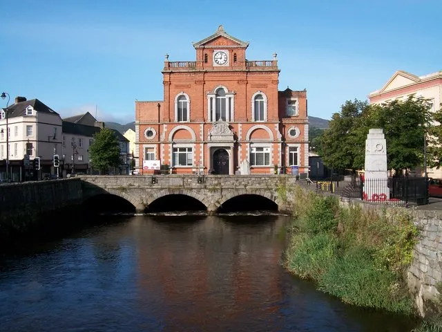
- Population
- 27,757
- 27.8K
- Elevation
- 6 m
- above sea level
- Local time
- UTC+00:00
- Europe/London · UTC+00:00
- Airports
- BFS Belfast International Airport54 km
- BHD George Best Belfast City Airport58 km
About Newry
Newry is a city. Location: Newry Mourne and Down, Northern Ireland. Population: 27,757. Elevation: 6 m.
Newry (; from Irish Iúr Cinn Trá) is a cathedral city in Northern Ireland, standing on the Clanrye River in counties Armagh and Down. It is near the border with the Republic of Ireland, on the main routes between Belfast (34 miles/55 km away) and Dublin (67 miles/108 km away). The population was 27,913 in 2021. Newry was founded in 1144 as a settlement around a Cistercian abbey. In the 16th century the English dissolved the abbey and built Bagenal's Castle on the site.
Source: Wikipedia · CC BY-SA 4.0
Photos of Newry
-

Eric Jones · CC BY-SA 2.0 -

Eric Jones · CC BY-SA 2.0 -

Unknown author Unknown author · Public domain -

Bernard Ladenthin · CC BY 4.0 -

Unknown author Unknown author · Public domain


Travel notes for Newry
From Wikivoyage
Newry is a town straddling the boundary between County Down and County Armagh in Northern Ireland, five miles north of the border with the Republic of Ireland. In 2002 it was upgraded to a city but this is just ceremonial, and the place continues to feel like a medium-sized town, with a population of 28,000 in 2021. The northern counties are no longer units of governance, and since 2015 Newry been governed as part of Newry, Mourne and Down District.
Understand+
Mountains obstruct the route from Dublin north along the coast into Ulster, but at Newry there's a gap, so roads (and later a canal and railway) head inland up the valley towards Portadown before swinging east into Belfast. The gap is a U-shaped glaciated valley that deepens into the fjord of Carlingford Lough, so there's also sea access. This was more of a curse than a blessing in the first millennium, since if there was one thing the Vikings enjoyed more than sailing into fjords, it was burning and pillaging the nearby settlements. The Normans put a stop to this, secured the area and founded an abbey. The town remained small until the 18th century when the growth of industry and transport made its position more important.
Ireland was divided into counties, which acquired local government councils in the 19th century, and Newry fell on the boundary of three. West of the river and fjord was County Armagh, east was County Down, and the town hall was symbolically built straddling the river. Five miles south was County Louth, which from 1921 belonged to a separate nation, the Republic of Ireland. Between them lay a higgledy-piggledy, porous and often dangerous border, with the main road checkpoint at Killeen, and for the rest of the 20th century this dominated Newry. There were killings and bombings during The Troubles from 1970, a heavy military presence, and a flight of industry and employment.
Get in+
Newry is midway between Dublin and Belfast, so you can use either city's airport or ferry port and travel onward by train or bus. By car follow M1 / A1: there's a toll at Drogheda to the south.
The Enterprise Train runs hourly, taking 70 min from Dublin Connolly via Drogheda and Dundalk, and an hour from Belfast via Portadown. Commuter trains between Bangor, Belfast and Portadown extend to Newry in rush hour.
1 Newry railway station is a mile northwest of town centre. The railway comes into the station over the Egyptian Arch Bridge (it's supposed to resemble a pharaoh's head-dress, you'll need to use your imagination) and continues north over the 18-arch Craigmore Viaduct.
Goldliner Bus 238 runs every 20 min from Belfast Grand Central via Hillsborough and Banbridge, taking 90 min to Newry.
Expressway Bus X1 runs from Dublin Busáras and Airport (DUB IATA) to Newry, 90 min, and continues to Banbridge, Sprucefield Shopping Centre near Lisburn and Belfast. It's hourly daytime and every two hours through the night.
Ulsterbus 40 runs every couple of hours from Armagh, taking 50 min.
Ulsterbus 63 runs every couple of hours from Portadown, taking an hour to Newry.
2 Newry Buscentre is on The Mall in town centre.
3 Carlingford Ferry crosses the channel between Greencastle in County Down and Greenore in the Republic east of Dundalk. It sails hourly Apr-Oct 10AM-6PM and the crossing takes 15 min.
Source: Wikivoyage · CC BY-SA 4.0 · abridged
Climate of Newry
Best months for sightseeingBest months for sightseeing: June–August.
This month · November
A wet month
Day 10° · Night 4° · Rain 125 mm
- Hottest month
- July (day 20°)
- Coldest month
- January (night 2°)
- Wettest month
- January (142 mm)
- Driest month
- May (74 mm)
Bars: average monthly low and high temperature. Below: precipitation. Monthly averages for 1970–2000 at about 18 km resolution, adjusted for elevation. Highlighted months are mild and relatively dry. Source: WorldClim 2.1 (CC BY 4.0).
Show values as a table
| Month | Jan | Feb | Mar | Apr | May | Jun | Jul | Aug | Sep | Oct | Nov | Dec |
|---|---|---|---|---|---|---|---|---|---|---|---|---|
| Average high (°C) | 7° | 8° | 10° | 13° | 16° | 18° | 20° | 20° | 17° | 14° | 10° | 8° |
| Average low (°C) | 2° | 2° | 3° | 4° | 7° | 9° | 12° | 11° | 9° | 7° | 4° | 3° |
| Precipitation (mm) | 142 | 109 | 114 | 77 | 74 | 78 | 75 | 98 | 97 | 125 | 125 | 132 |
How to get to Newry
The nearest airport is Belfast International Airport (BFS), 54 km to the north as the crow flies. The nearest large city is Belfast, 54 km to the northeast.
Airports
- Belfast International Airport (BFS) Belfast 54 kmnorth
- George Best Belfast City Airport (BHD) Belfast 58 kmnortheast
- Dublin Airport (DUB) Dublin 84 kmsouth
Nearby large cities
- Belfast Population: 348K 54 kmnortheast
- Dublin Population: 1M 94 kmsouth
- Blackpool Population: 145K 219 kmeast
- Limerick Population: 102.3K 227 kmsouthwest
- Glasgow Population: 626.4K 230 kmnortheast
Straight-line distances; road distances are longer. Airport data: OurAirports.
Day trips from Newry
Within 100 km: 195 historic and cultural sites, 349 natural sites, 502 lakes, rivers and coasts.
0–25 km101 places
- Tullynawood Lake Lake 23 kmW
- Silent Valley Reservoir Lake 23 kmE
- Lough Shark Lake 16 kmN
- Lough Shannagh Lake 21 kmE
25–60 km289 places
- Reedy Flat Island 39 kmN
- Reagh Island Island 58 kmNE
- Rams Island Island 45 kmN
- Guns Island Island 53 kmE
60–100 km656 places
- Rockabill Island 68 kmS
- Pollboy Bridge Landmark 63 kmS
- Sandymount Strand Beach 95 kmS
- Portmarnock Beach Beach 86 kmS
Straight-line distances.
Nearby attractions & nature
Everything nearby-
Cloghoge Mountain Mountain, Newry Mourne and Down3.4 km S
-
Camlough Mountain Mountain, Newry Mourne and Down4 km W
-
Greenan Mountain, Newry Mourne and Down4.5 km SE
-
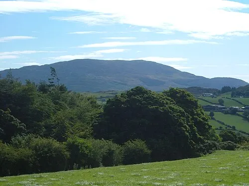 Slieve Gullion Mountain, Newry Mourne and Down8 km SW
-
Tullyhappy Mountain, Newry Mourne and Down7.2 km NW
-
Sugarloaf Hill Mountain, Newry Mourne and Down7.4 km W
-
Slieveacarnane Mountain, Newry Mourne and Down7.4 km E
-
Camlough Reservoir Lake, Northern Ireland6.1 km SW
Sources & licences
Data last updated: · 2 independent sources