- Elevation
- 433 m
- above sea level
- Local time
- UTC+00:00
- Europe/London · UTC+00:00
- Airports
- TRE Tiree Airport48 km
- ILY Islay Airport83 km
About A' Mhaol Mhor
A' Mhaol Mhor is a mountain. Location: Argyll and Bute, Scotland. Elevation: 433 m. The nearest airport is Tiree Airport (48 km). Nearby sights include Coirc Bheinn and Beinn na Sreine.
Photos of A' Mhaol Mhor
-
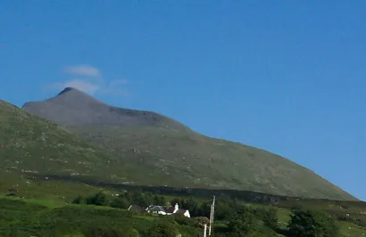
Ben More Released into public domain by author/original uploader was Deus Ex at en.wikipedia · Public domain

Climate of A' Mhaol Mhor
This month · November
A wet month
Day 7° · Night 4° · Rain 246 mm
- Hottest month
- August (day 15°)
- Coldest month
- February (night 2°)
- Wettest month
- January (266 mm)
- Driest month
- May (99 mm)
Bars: average monthly low and high temperature. Below: precipitation. Monthly averages for 1970–2000 at about 18 km resolution, adjusted for elevation. Highlighted months are mild and relatively dry. Source: WorldClim 2.1 (CC BY 4.0).
Show values as a table
| Month | Jan | Feb | Mar | Apr | May | Jun | Jul | Aug | Sep | Oct | Nov | Dec |
|---|---|---|---|---|---|---|---|---|---|---|---|---|
| Average high (°C) | 5° | 5° | 6° | 8° | 11° | 13° | 14° | 15° | 13° | 10° | 7° | 5° |
| Average low (°C) | 2° | 2° | 2° | 3° | 6° | 8° | 10° | 10° | 8° | 6° | 4° | 2° |
| Precipitation (mm) | 266 | 163 | 207 | 121 | 99 | 103 | 131 | 159 | 216 | 237 | 246 | 239 |
How to get to A' Mhaol Mhor
The nearest airport is Tiree Airport (TRE), 48 km to the west as the crow flies. The nearest large city is Glasgow, 131 km to the southeast.
Airports
- Tiree Airport (TRE) Balemartine, Argyll and Bute 48 kmwest
- Islay Airport (ILY) Isle of Islay, Argyll and Bute 83 kmsouth
- Barra Airport (BRR) Eoligarry 105 kmnorthwest
Nearby large cities
- Glasgow Population: 626.4K 131 kmsoutheast
- Edinburgh Population: 515K 188 kmeast
- Dundee Population: 148.2K 193 kmeast
- Belfast Population: 348K 204 kmsouth
- Aberdeen Population: 198.6K 258 kmeast
Straight-line distances; road distances are longer. Airport data: OurAirports.
Day trips from A' Mhaol Mhor
Within 100 km: 38 historic and cultural sites, 2,786 natural sites, 1,170 lakes, rivers and coasts.
0–25 km312 places
- Ulva Island 10 kmNW
- Treshnish Isles Island 20 kmNW
- Rèidh Eilean Island 23 kmW
- Isle of Mull Island 13 kmE
25–60 km1,423 places
- Colonsay Island 41 kmS
- Eigg Island 53 kmN
- Kiloran Beach Beach 36 kmS
- Scarba Island 36 kmSE
60–100 km2,259 places
- Hebrides Island 74 kmNW
- Isle of Skye Island 98 kmN
- Scalpay Island 96 kmN
- Dùn Mòr Island 72 kmN
Straight-line distances.
Nearest towns and villages
-
Gribun Village, Argyll and Bute1.8 km W
-
Balnahard Village, Argyll and Bute1.9 km NW
-
Clachandhu Village, Argyll and Bute2.1 km NW
-
Balmeanach Village, Argyll and Bute2.2 km W
-
Dishig Village, Argyll and Bute2.3 km NW
-
Kilfinchen Village, Argyll and Bute5.4 km SE
Nearby attractions & nature
Everything nearby-
Coirc Bheinn Mountain, Argyll and Bute2 km SE
-
Beinn na Sreine Mountain, Argyll and Bute3.4 km S
-
Ben More Mountain, Argyll and Bute5.6 km E
-
Samalan Island Island, Argyll and Bute3.4 km NW
-
Fionna Mham Mountain, Argyll and Bute4.4 km SW
-
Inch Kenneth Island, Argyll and Bute3.9 km NW
-
Geasgill Beag Island, Argyll and Bute4.6 km NW
-
Eorsa Island Island, Argyll and Bute4.7 km N
Sources & licences
Data last updated: