Carn Airigh Shomhairle
Located in Argyll and Bute, Scotland Coordinates: 56°03′33″ N 6°12′59″ W
- Elevation
- 76 m
- above sea level
- Local time
- UTC+00:00
- Europe/London · UTC+00:00
- Airports
- ILY Islay Airport42 km
- TRE Tiree Airport64 km
About Carn Airigh Shomhairle
Carn Airigh Shomhairle is a mountain. Location: Argyll and Bute, Scotland. Elevation: 76 m. The best months to visit are July. The nearest airport is Islay Airport (42 km). Nearby sights include Colonsay and Cnoc an t-Samhla.
Photos of Carn Airigh Shomhairle
-
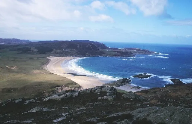
Colonsay Richard Webb · CC BY-SA 2.0

Climate of Carn Airigh Shomhairle
Best months for sightseeingBest months for sightseeing: July.
This month · November
A wet month
Day 10° · Night 6° · Rain 179 mm
- Hottest month
- August (day 17°)
- Coldest month
- February (night 4°)
- Wettest month
- January (196 mm)
- Driest month
- May (67 mm)
Bars: average monthly low and high temperature. Below: precipitation. Monthly averages for 1970–2000 at about 18 km resolution, adjusted for elevation. Highlighted months are mild and relatively dry. Source: WorldClim 2.1 (CC BY 4.0).
Show values as a table
| Month | Jan | Feb | Mar | Apr | May | Jun | Jul | Aug | Sep | Oct | Nov | Dec |
|---|---|---|---|---|---|---|---|---|---|---|---|---|
| Average high (°C) | 8° | 7° | 9° | 10° | 13° | 15° | 16° | 17° | 15° | 12° | 10° | 8° |
| Average low (°C) | 4° | 4° | 4° | 5° | 8° | 10° | 12° | 12° | 10° | 8° | 6° | 4° |
| Precipitation (mm) | 196 | 117 | 145 | 87 | 67 | 77 | 100 | 121 | 157 | 177 | 179 | 174 |
Other places to visit in this season: July
How to get to Carn Airigh Shomhairle
The nearest airport is Islay Airport (ILY), 42 km to the south as the crow flies. The nearest large city is Glasgow, 124 km to the east.
Airports
- Islay Airport (ILY) Isle of Islay, Argyll and Bute 42 kmsouth
- Tiree Airport (TRE) Balemartine, Argyll and Bute 64 kmnorthwest
- Campbeltown Airport (CAL) Campbeltown 77 kmsoutheast
Nearby large cities
- Glasgow Population: 626.4K 124 kmeast
- Belfast Population: 348K 164 kmsouth
- Edinburgh Population: 515K 189 kmeast
- Dundee Population: 148.2K 206 kmeast
- Aberdeen Population: 198.6K 280 kmnortheast
Straight-line distances; road distances are longer. Airport data: OurAirports.
Day trips from Carn Airigh Shomhairle
Within 100 km: 58 historic and cultural sites, 2,061 natural sites, 1,028 lakes, rivers and coasts.
0–25 km173 places
- Colonsay Island 1 kmN
- Kiloran Beach Beach 5 kmNE
- Oronsay Island 6 kmSW
- Eilean nan Ròn Island 7 kmSW
25–60 km1,203 places
- Scarba Island 34 kmNE
- Cala Island 38 kmE
- Ulva Island 47 kmN
- Treshnish Isles Island 50 kmN
60–100 km1,771 places
- Isle of Arran Island 79 kmSE
- Great Cumbrae Island Island 87 kmE
- Eigg Island 94 kmN
- Hunterston Sands Beach 90 kmSE
Straight-line distances.
Nearest towns and villages
-
Isle of Colonsay Village, Argyll and Bute2.4 km N
-
Upper Kilchattan Village, Argyll and Bute0.8 km N
-
Kilchattan Village, Argyll and Bute0.8 km N
-
Scalasaig Village, Argyll and Bute2 km NE
-
Lower Kilchattan Village, Argyll and Bute2.2 km NW
-
Balaruminmore Village, Argyll and Bute3 km S
Nearby attractions & nature
Everything nearby-
Colonsay Island, Argyll and Bute0.8 km N
-
Cnoc an t-Samhla Mountain, Argyll and Bute0.9 km SE
-
Beinn Arnicil Mountain, Argyll and Bute1.2 km S
-
Cnoc na Faire Mor Mountain, Argyll and Bute1.6 km NE
-
Carn Mor Mountain, Argyll and Bute1.6 km N
-
Loch Fada Lake, Argyll and Bute1.3 km NE
-
Carn Spiris Mountain, Argyll and Bute1.8 km SW
-
Beinn nan Gudairean Mountain, Argyll and Bute2.2 km NE
Sources & licences
Data last updated: