Mull of Oa
Local name: Maol na h-Obha
Located in Argyll and Bute, Scotland Coordinates: 55°35′00″ N 6°19′00″ W
- Local time
- UTC+00:00
- Europe/London · UTC+00:00
- Airports
- ILY Islay Airport12 km
- CAL Campbeltown Airport43 km
About Mull of Oa
Mull of Oa is a natural site. Location: Argyll and Bute, Scotland. The best months to visit are June–August. The nearest airport is Islay Airport (12 km). Nearby sights include Dun Athad and Beinn Mhor.
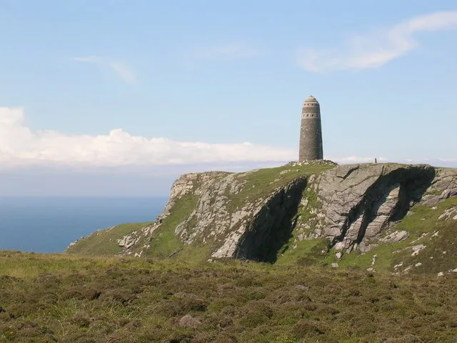
Photos of Mull of Oa
-

ErikRombaut · CC BY-SA 4.0 -

thejackrustles · CC BY-SA 2.0 -

thejackrustles · CC BY-SA 2.0 -

Malcolm Neal · CC BY-SA 2.0 -

Gordon Hatton · CC BY-SA 2.0


Climate of Mull of Oa
Best months for sightseeingBest months for sightseeing: June–August.
This month · November
A wet month
Day 10° · Night 5° · Rain 155 mm
- Hottest month
- August (day 17°)
- Coldest month
- February (night 3°)
- Wettest month
- January (171 mm)
- Driest month
- May (60 mm)
Bars: average monthly low and high temperature. Below: precipitation. Monthly averages for 1970–2000 at about 18 km resolution, adjusted for elevation. Highlighted months are mild and relatively dry. Source: WorldClim 2.1 (CC BY 4.0).
Show values as a table
| Month | Jan | Feb | Mar | Apr | May | Jun | Jul | Aug | Sep | Oct | Nov | Dec |
|---|---|---|---|---|---|---|---|---|---|---|---|---|
| Average high (°C) | 8° | 8° | 9° | 11° | 14° | 15° | 17° | 17° | 15° | 13° | 10° | 8° |
| Average low (°C) | 3° | 3° | 4° | 5° | 7° | 9° | 11° | 11° | 10° | 8° | 5° | 4° |
| Precipitation (mm) | 171 | 103 | 129 | 80 | 60 | 75 | 94 | 109 | 136 | 160 | 155 | 151 |
How to get to Mull of Oa
The nearest airport is Islay Airport (ILY), 12 km to the north as the crow flies. The nearest large city is Belfast, 113 km to the south.
Airports
- Islay Airport (ILY) Isle of Islay, Argyll and Bute 12 kmnorth
- Campbeltown Airport (CAL) Campbeltown 43 kmeast
- City of Derry Airport (LDY) Derry, Derry and Strabane 81 kmsouthwest
Nearby large cities
- Belfast Population: 348K 113 kmsouth
- Glasgow Population: 626.4K 133 kmeast
- Edinburgh Population: 515K 200 kmeast
- Dundee Population: 148.2K 230 kmnortheast
- Dublin Population: 1M 251 kmsouth
Straight-line distances; road distances are longer. Airport data: OurAirports.
Day trips from Mull of Oa
Within 100 km: 67 historic and cultural sites, 1,319 natural sites, 683 lakes, rivers and coasts.
0–25 km123 places
- Texa Island Island 11 kmE
- Oversay Island Island 16 kmNW
- Eilean a’ Chùirn Island 21 kmNE
- Eilean Craobhach Island 21 kmNE
25–60 km567 places
- Colonsay Island 54 kmN
- Kiloran Beach Beach 58 kmN
- Portstewart Beach Beach 53 kmSW
- Benone Beach Beach 58 kmSW
60–100 km1,379 places
- Isle of Arran Island 67 kmE
- Great Cumbrae Island Island 90 kmE
- Hunterston Sands Beach 91 kmE
- Lisfannon Beach Beach 92 kmSW
Straight-line distances.
Nearest towns and villages
-
 Ballychatrigan Village, Argyll and Bute4.7 km E
-
Port Ellen Village, Argyll and Bute10 km NE
-
Kintra Village, Argyll and Bute8.6 km NE
-
Imeraval Neighbourhood, Argyll and Bute9 km NE
-
Laphroaig Village, Argyll and Bute11 km E
-
Glenegedale Village, Argyll and Bute12 km N
Nearby attractions & nature
Everything nearby-
Dun Athad Mountain, Argyll and Bute0.4 km E
-
Beinn Mhor Mountain, Argyll and Bute1.4 km E
-
Loch na Beinne Lake, Argyll and Bute2 km E
-
Loch Kinnabus Lake, Argyll and Bute2.6 km NE
-
Lower Glen Astle Natural site, Scotland3.9 km N
-
Eilean Bhràidebig Island, Argyll and Bute3 km E
-
Maol Beag Mountain, Argyll and Bute3.9 km NE
-
Maol Mhor Mountain, Argyll and Bute4 km N
Sources & licences
Data last updated: · 2 independent sources