- Elevation
- 141 m
- above sea level
- Local time
- UTC+00:00
- Europe/London · UTC+00:00
- Airports
- PIK Glasgow Prestwick Airport74 km
- EDI Edinburgh Airport99 km
About Terregles
Terregles is a village. Location: Dumfries and Galloway, Scotland. Elevation: 141 m. The best months to visit are June–August. The nearest airport is Glasgow Prestwick Airport (74 km). Nearby sights include White Hill of Terregles and Beacon Hill.
Photos of Terregles
-
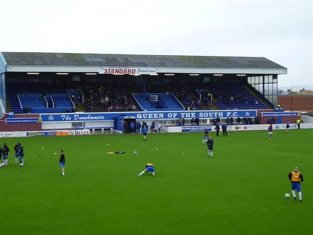
Palmerston Park en:User:Jmorrison230582 · CC BY-SA 3.0

Climate of Terregles
Best months for sightseeingBest months for sightseeing: June–August.
This month · November
A wet month
Day 8° · Night 3° · Rain 132 mm
- Hottest month
- July (day 18°)
- Coldest month
- January (night 1°)
- Wettest month
- January (139 mm)
- Driest month
- April (63 mm)
Bars: average monthly low and high temperature. Below: precipitation. Monthly averages for 1970–2000 at about 18 km resolution, adjusted for elevation. Highlighted months are mild and relatively dry. Source: WorldClim 2.1 (CC BY 4.0).
Show values as a table
| Month | Jan | Feb | Mar | Apr | May | Jun | Jul | Aug | Sep | Oct | Nov | Dec |
|---|---|---|---|---|---|---|---|---|---|---|---|---|
| Average high (°C) | 6° | 6° | 8° | 11° | 14° | 16° | 18° | 18° | 15° | 12° | 8° | 6° |
| Average low (°C) | 1° | 1° | 2° | 3° | 6° | 9° | 11° | 10° | 8° | 6° | 3° | 2° |
| Precipitation (mm) | 139 | 99 | 102 | 63 | 72 | 66 | 75 | 90 | 106 | 137 | 132 | 137 |
How to get to Terregles
The nearest airport is Glasgow Prestwick Airport (PIK), 74 km to the northwest as the crow flies. The nearest large city is Glasgow, 95 km to the north.
Airports
- Glasgow Prestwick Airport (PIK) Prestwick, South Ayrshire 74 kmnorthwest
- Edinburgh Airport (EDI) Ingliston, Edinburgh 99 kmnorth
- Glasgow Airport (GLA) Glasgow 100 kmnorthwest
Nearby large cities
- Glasgow Population: 626.4K 95 kmnorth
- Edinburgh Population: 515K 102 kmnorth
- Newcastle upon Tyne Population: 300.1K 133 kmeast
- Blackpool Population: 145K 146 kmsouth
- Sunderland Population: 170.1K 148 kmeast
Straight-line distances; road distances are longer. Airport data: OurAirports.
Day trips from Terregles
Within 100 km: 411 historic and cultural sites, 3,061 natural sites, 720 lakes, rivers and coasts.
0–25 km294 places
- Powillimount Beach Beach 22 kmS
- Cottage Island Island 19 kmE
- Dormont Island Island 18 kmE
- Danevale Island Island 23 kmSW
25–60 km1,518 places
- Murrays Isles Island 46 kmSW
- Hestan Island Island 29 kmS
- Islands of Fleet Island 46 kmSW
- Ardwall Isle Island 45 kmSW
60–100 km2,380 places
- St. Bees Beach Seafront Beach 66 kmS
- Ayr Beach Beach 75 kmNW
- Troon Beach Beach 81 kmNW
- Tuft Rock Island 92 kmSE
Straight-line distances.
Nearby attractions & nature
Everything nearby-
White Hill of Terregles Mountain, Dumfries and Galloway1.4 km W
-
Beacon Hill Mountain, Dumfries and Galloway1.6 km SW
-
Collochan Hill Mountain, Dumfries and Galloway2 km SW
-
Bonerick Hill Mountain, Dumfries and Galloway2.3 km W
-
Cluden Water River, Scotland1.4 km NW
-
Palmerston Park Landmark, Dumfries and Galloway3.6 km E
Sources & licences
Data last updated: