- Elevation
- 178 m
- above sea level
- Local time
- UTC+00:00
- Europe/London · UTC+00:00
- Airports
- INV Inverness Airport54 km
- WIC Wick John O'Groats Airport79 km
About East Langwell
East Langwell is a village. Location: Highland, Scotland. Elevation: 178 m. The best months to visit are July–August. The nearest airport is Inverness Airport (54 km). Nearby sights include Creag na Croiche and Cnoc Ard an Tionail.
Photos of East Langwell
-
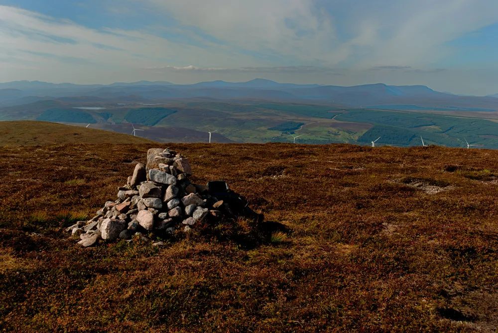
Ben Horn Peter Moore · CC BY-SA 2.0

Climate of East Langwell
Best months for sightseeingBest months for sightseeing: July–August.
This month · November
A wet month
Day 8° · Night 2° · Rain 132 mm
- Hottest month
- July (day 17°)
- Coldest month
- February (night 0°)
- Wettest month
- November (132 mm)
- Driest month
- May (67 mm)
Bars: average monthly low and high temperature. Below: precipitation. Monthly averages for 1970–2000 at about 18 km resolution, adjusted for elevation. Highlighted months are mild and relatively dry. Source: WorldClim 2.1 (CC BY 4.0).
Show values as a table
| Month | Jan | Feb | Mar | Apr | May | Jun | Jul | Aug | Sep | Oct | Nov | Dec |
|---|---|---|---|---|---|---|---|---|---|---|---|---|
| Average high (°C) | 5° | 6° | 7° | 10° | 13° | 15° | 17° | 17° | 14° | 12° | 8° | 6° |
| Average low (°C) | 0° | 0° | 1° | 2° | 5° | 8° | 10° | 9° | 7° | 5° | 2° | 0° |
| Precipitation (mm) | 123 | 86 | 109 | 70 | 67 | 77 | 82 | 93 | 114 | 125 | 132 | 121 |
How to get to East Langwell
The nearest airport is Inverness Airport (INV), 54 km to the south as the crow flies. The nearest large city is Aberdeen, 158 km to the southeast.
Airports
- Inverness Airport (INV) Inverness, Highland 54 kmsouth
- Wick John O'Groats Airport (WIC) Wick 79 kmnortheast
- Kirkwall Airport (KOI) Kirkwall, Orkney Islands 127 kmnortheast
Nearby large cities
- Aberdeen Population: 198.6K 158 kmsoutheast
- Dundee Population: 148.2K 188 kmsoutheast
- Edinburgh Population: 515K 238 kmsouth
- Glasgow Population: 626.4K 241 kmsouth
- Newcastle upon Tyne Population: 300.1K 374 kmsoutheast
Straight-line distances; road distances are longer. Airport data: OurAirports.
Day trips from East Langwell
Within 100 km: 52 historic and cultural sites, 2,737 natural sites, 708 lakes, rivers and coasts.
0–25 km244 places
- Eilean nan Ròn Island 19 kmSW
- Eilean a' Chairn Island 15 kmW
- Eilean na Craoibhe Island 15 kmW
- Eilean na h-Aibhne Island 19 kmSW
25–60 km1,058 places
- Moy Island Island 57 kmSW
- Eilean nan Ron Island 60 kmN
- Rabbit Islands Island 58 kmN
- Neave Island Island 59 kmN
60–100 km2,195 places
- Findlays Seat Mountain 77 kmSE
- Lossiemouth East Beach Beach 62 kmSE
- Sunnyside Beach Beach 90 kmSE
- Clett Island 75 kmNE
Straight-line distances.
Nearby attractions & nature
Everything nearby-
Creag na Croiche Mountain, Highland2.3 km S
-
Cnoc Ard an Tionail Mountain, Highland2.4 km E
-
Creag Bhreac Mountain, Highland3 km SW
-
Cnoc-an-t-sidhean Mountain, Highland3 km SE
-
Creag a' Bhata Mountain, Highland3.3 km S
-
Creag na Dalach Moire Mountain, Highland3.7 km SW
Other cities and towns in Highland
-
 Golspie Village, Highland12 km SE
-
 West Langwell Village, Highland3.7 km NW
-
Blairmore Neighbourhood, Highland2.5 km SE
-
Farlary Village, Highland4 km E
-
Pittentrail Village, Highland4 km S
-
Muie Village, Highland6 km W
Sources & licences
Data last updated: