- Elevation
- 53 m
- above sea level
- Local time
- UTC+00:00
- Europe/London · UTC+00:00
- Airports
- WIC Wick John O'Groats Airport71 km
- KOI Kirkwall Airport93 km
About Tubeg
Tubeg is a neighbourhood. Location: Highland, Scotland. The best months to visit are July–August. The nearest airport is Wick John O'Groats Airport (71 km). Nearby sights include Skerray Bay and Am Breac-leathad.
Photos of Tubeg
-
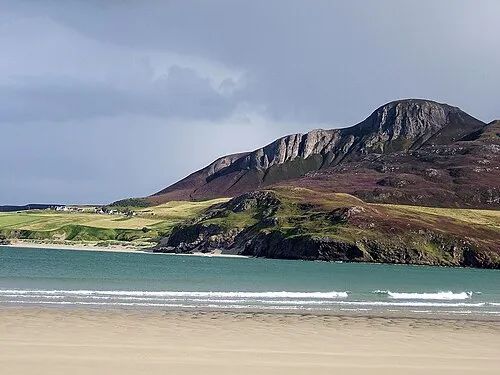
Cnoc an Fhreiceadain Brian Smith · CC BY-SA 2.0

Climate of Tubeg
Best months for sightseeingBest months for sightseeing: July–August.
This month · November
A wet month
Day 9° · Night 4° · Rain 137 mm
- Hottest month
- August (day 16°)
- Coldest month
- February (night 1°)
- Wettest month
- November (137 mm)
- Driest month
- May (63 mm)
Bars: average monthly low and high temperature. Below: precipitation. Monthly averages for 1970–2000 at about 18 km resolution, adjusted for elevation. Highlighted months are mild and relatively dry. Source: WorldClim 2.1 (CC BY 4.0).
Show values as a table
| Month | Jan | Feb | Mar | Apr | May | Jun | Jul | Aug | Sep | Oct | Nov | Dec |
|---|---|---|---|---|---|---|---|---|---|---|---|---|
| Average high (°C) | 6° | 6° | 8° | 9° | 12° | 14° | 16° | 16° | 14° | 12° | 9° | 7° |
| Average low (°C) | 2° | 1° | 2° | 4° | 6° | 8° | 10° | 10° | 9° | 7° | 4° | 2° |
| Precipitation (mm) | 117 | 84 | 103 | 68 | 63 | 72 | 80 | 92 | 116 | 129 | 137 | 121 |
How to get to Tubeg
The nearest airport is Wick John O'Groats Airport (WIC), 71 km to the east as the crow flies. The nearest large city is Aberdeen, 203 km to the southeast.
Airports
- Wick John O'Groats Airport (WIC) Wick 71 kmeast
- Kirkwall Airport (KOI) Kirkwall, Orkney Islands 93 kmnortheast
- Inverness Airport (INV) Inverness, Highland 112 kmsouth
Nearby large cities
- Aberdeen Population: 198.6K 203 kmsoutheast
- Dundee Population: 148.2K 244 kmsouth
- Edinburgh Population: 515K 296 kmsouth
- Glasgow Population: 626.4K 298 kmsouth
Straight-line distances; road distances are longer. Airport data: OurAirports.
Day trips from Tubeg
Within 100 km: 40 historic and cultural sites, 1,672 natural sites, 521 lakes, rivers and coasts.
0–25 km210 places
- Eilean nan Ron Island 3 kmNW
- Rabbit Islands Island 5 kmW
- Neave Island Island 1 kmN
- Eilean Iosal Island 4 kmNW
25–60 km838 places
- Clett Island 45 kmE
- Eilean Dubh Island 56 kmSW
- Whale Islet Island 50 kmW
- Meall Mòr Island 60 kmSW
60–100 km1,185 places
- Hoy Island 68 kmNE
- Shapinsay Island 100 kmNE
- Flotta Island 76 kmNE
- Gairsay Island 98 kmNE
Straight-line distances.
Nearby attractions & nature
Everything nearby-
Skerray Bay Natural site, United Kingdom0.4 km N
-
Am Breac-leathad Mountain, Highland0.5 km W
-
Cnoc nan Uan Mountain, Highland0.8 km E
-
Stac a' Bhagh Mountain, Highland1.1 km N
-
Neave Island Island, Highland1.1 km N
-
Neave Island / Comb Island Island, Highland1.1 km NE
Other cities and towns in Highland
-
Torrisdale Village, Highland2.4 km SE
-
Achtoly Village, Highland1.2 km SE
-
 Skullomie Village, Highland4.8 km SW
-
Modsary Neighbourhood, Highland1.6 km SW
-
Strathan Skerray Village, Highland1.9 km W
-
 Bettyhill Village, Highland4.9 km E
Sources & licences
Data last updated: