- Elevation
- 214 m
- above sea level
- Local time
- UTC+00:00
- Europe/London · UTC+00:00
- Airports
- INV Inverness Airport48 km
- ABZ Aberdeen International Airport71 km
About Bridgend of Livet
Bridgend of Livet is a village. Location: Moray, Scotland. Elevation: 214 m. The best months to visit are June–August. The nearest airport is Inverness Airport (48 km). Nearby sights include River Livet and Doune of Dalmore.
Photos of Bridgend of Livet
-
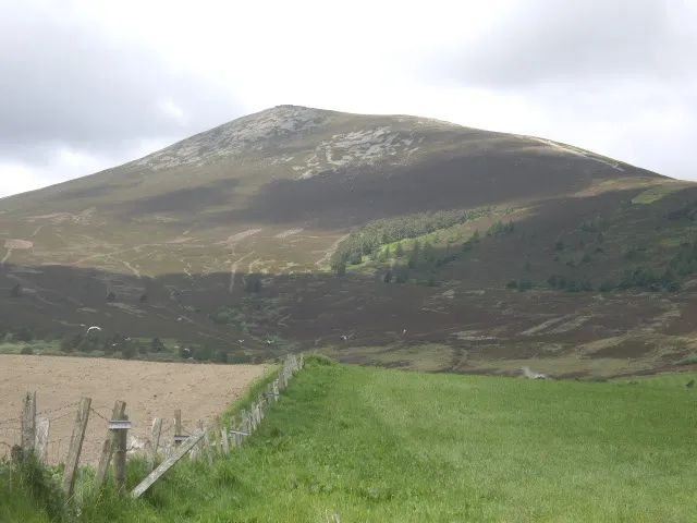
Ben Rinnes Stanley Howe · CC BY-SA 2.0

Climate of Bridgend of Livet
Best months for sightseeingBest months for sightseeing: June–August.
This month · November
A cold month
Day 8° · Night 2° · Rain 88 mm
- Hottest month
- July (day 18°)
- Coldest month
- February (night -1°)
- Wettest month
- January (97 mm)
- Driest month
- April (54 mm)
Bars: average monthly low and high temperature. Below: precipitation. Monthly averages for 1970–2000 at about 18 km resolution, adjusted for elevation. Highlighted months are mild and relatively dry. Source: WorldClim 2.1 (CC BY 4.0).
Show values as a table
| Month | Jan | Feb | Mar | Apr | May | Jun | Jul | Aug | Sep | Oct | Nov | Dec |
|---|---|---|---|---|---|---|---|---|---|---|---|---|
| Average high (°C) | 5° | 6° | 7° | 10° | 13° | 16° | 18° | 18° | 15° | 12° | 8° | 6° |
| Average low (°C) | 0° | -1° | 1° | 2° | 5° | 8° | 10° | 9° | 7° | 5° | 2° | 0° |
| Precipitation (mm) | 97 | 65 | 76 | 54 | 59 | 62 | 61 | 71 | 82 | 93 | 88 | 84 |
How to get to Bridgend of Livet
The nearest airport is Inverness Airport (INV), 48 km to the northwest as the crow flies. For international flights: Aberdeen International Airport (ABZ) (71 km). The nearest large city is Aberdeen, 78 km to the east.
Airports
- Inverness Airport (INV) Inverness, Highland 48 kmnorthwest
- Aberdeen International Airport (ABZ) Aberdeen 71 kmeast
- Dundee Airport (DND) Dundee 102 kmsouth
Nearby large cities
- Aberdeen Population: 198.6K 78 kmeast
- Dundee Population: 148.2K 101 kmsouth
- Edinburgh Population: 515K 156 kmsouth
- Glasgow Population: 626.4K 175 kmsouth
- Newcastle upon Tyne Population: 300.1K 286 kmsoutheast
Straight-line distances; road distances are longer. Airport data: OurAirports.
Day trips from Bridgend of Livet
Within 100 km: 79 historic and cultural sites, 3,042 natural sites, 569 lakes, rivers and coasts.
0–25 km282 places
- Island of Dundurcas Island 23 kmNE
- Heathery Isle Island 18 kmNE
- Island Roary Island 11 kmN
- Craigroy Island Island 9 kmN
25–60 km1,191 places
- Findlays Seat Mountain 25 kmN
- Lossiemouth East Beach Beach 41 kmN
- Sunnyside Beach Beach 50 kmNE
- Eilean nan Faoileag Island 57 kmW
60–100 km2,217 places
- Balbithan Island Island 62 kmE
- Newburgh Seals Beach Beach 81 kmE
- Aberdeen Beach Beach 79 kmE
- Moy Island Island 75 kmW
Straight-line distances.
Nearby attractions & nature
Everything nearby-
River Livet River, Moray0.9 km SW
-
Doune of Dalmore Mountain, Moray1.5 km NW
-
Tom Dubh Mountain, Moray1.5 km SE
-
Burn of Tervie River, Moray2.3 km S
-
Cairnacay Mountain, Moray2.9 km N
-
Carn Liath Mountain, Moray3.3 km S
Other cities and towns in Moray
-
 Dufftown Village, Moray16 km NE
-
Ballindalloch Village, Moray6.5 km N
-
Marypark Village, Moray8.4 km N
-
Achnastank Village, Moray8.9 km E
-
Charlestown of Aberlour Village, Moray15 km NE
-
Bridge-end Village, Moray6.1 km N
Sources & licences
Data last updated: