Meall a' Choire Odhair
Located in Perth and Kinross, Scotland Coordinates: 56°18′12″ N 3°55′49″ W
- Elevation
- 357 m
- above sea level
- Local time
- UTC+00:00
- Europe/London · UTC+00:00
- Airports
- EDI Edinburgh Airport52 km
- GLA Glasgow Airport57 km
About Meall a' Choire Odhair
Meall a' Choire Odhair is a mountain. Location: Perth and Kinross, Scotland. Elevation: 357 m. The best months to visit are July–August. The nearest airport is Edinburgh Airport (52 km). Nearby sights include Cromlet and Meall a' Choire Riabhaich.
Photos of Meall a' Choire Odhair
-
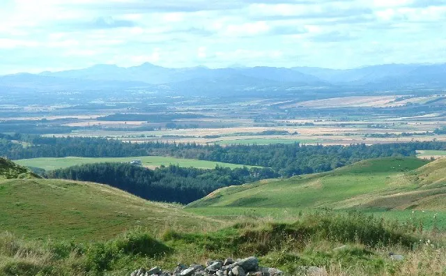
Strath Earn Robert Bone · CC BY-SA 2.0

Climate of Meall a' Choire Odhair
Best months for sightseeingBest months for sightseeing: July–August.
This month · November
A wet month
Day 7° · Night 1° · Rain 141 mm
- Hottest month
- July (day 17°)
- Coldest month
- January (night -1°)
- Wettest month
- January (167 mm)
- Driest month
- April (67 mm)
Bars: average monthly low and high temperature. Below: precipitation. Monthly averages for 1970–2000 at about 18 km resolution, adjusted for elevation. Highlighted months are mild and relatively dry. Source: WorldClim 2.1 (CC BY 4.0).
Show values as a table
| Month | Jan | Feb | Mar | Apr | May | Jun | Jul | Aug | Sep | Oct | Nov | Dec |
|---|---|---|---|---|---|---|---|---|---|---|---|---|
| Average high (°C) | 4° | 4° | 6° | 9° | 13° | 15° | 17° | 16° | 13° | 10° | 7° | 5° |
| Average low (°C) | -1° | -1° | 0° | 1° | 4° | 7° | 9° | 9° | 7° | 4° | 1° | -1° |
| Precipitation (mm) | 167 | 109 | 119 | 67 | 78 | 73 | 79 | 91 | 122 | 146 | 141 | 146 |
How to get to Meall a' Choire Odhair
The nearest airport is Edinburgh Airport (EDI), 52 km to the southeast as the crow flies. The nearest large city is Glasgow, 53 km to the southwest.
Airports
- Edinburgh Airport (EDI) Ingliston, Edinburgh 52 kmsoutheast
- Glasgow Airport (GLA) Glasgow 57 kmsouthwest
- Dundee Airport (DND) Dundee 58 kmeast
Nearby large cities
- Glasgow Population: 626.4K 53 kmsouthwest
- Edinburgh Population: 515K 60 kmsoutheast
- Dundee Population: 148.2K 62 kmeast
- Aberdeen Population: 198.6K 146 kmnortheast
- Newcastle upon Tyne Population: 300.1K 208 kmsoutheast
Straight-line distances; road distances are longer. Airport data: OurAirports.
Day trips from Meall a' Choire Odhair
Within 100 km: 192 historic and cultural sites, 3,935 natural sites, 983 lakes, rivers and coasts.
0–25 km307 places
- An t-Eilean Island 15 kmNW
- Inch Island 23 kmS
- Neish Island Island 15 kmNW
- Dargill Island Island 8 kmNE
25–60 km1,430 places
- Burntisland Beach Beach 51 kmSE
- Cramond beach Beach 53 kmSE
- Mugdrum Island Island 42 kmE
- Inchlonaig Island 48 kmSW
60–100 km3,373 places
- Great Cumbrae Island Island 86 kmSW
- Troon Beach Beach 96 kmSW
- Hunterston Sands Beach 88 kmSW
- Portobello Beach Beach 64 kmSE
Straight-line distances.
Nearest towns and villages

Nearby attractions & nature
Everything nearby-
Cromlet Mountain, Perth and Kinross2.8 km SW
-
Meall a' Choire Riabhaich Mountain, Perth and Kinross3.7 km W
-
Water of Ruchill River, Perth and Kinross4 km SW
-
Lurgan Hill Mountain, Perth and Kinross4.6 km N
-
Little Hill Mountain, Perth and Kinross4.6 km NW
-
Ben Clach Mountain, Perth and Kinross4.9 km W
-
Beinn Dubh Mountain, Perth and Kinross4.9 km NW
-
Torlum Mountain, Perth and Kinross5.4 km N
More nature in United Kingdom
-
Ben Clach North Top Mountain, Perth and Kinross5.7 km NW
-
Strath Earn Natural site, Perth and Kinross7.9 km NE
-
Easter Meiggar Hill Mountain, Perth and Kinross6.2 km NW
-
Findhu Glen Natural site, Perth and Kinross8.5 km W
-
Drumchork Mountain, Perth and Kinross6.3 km NW
-
Newburgh Wood Mountain, Perth and Kinross6.4 km N
Sources & licences
Data last updated: