- Elevation
- 119 m
- above sea level
- Local time
- UTC+00:00
- Europe/London · UTC+00:00
- Airports
- LPL Liverpool John Lennon Airport103 km
- MAN Manchester Airport135 km
About Pen Erw-goed
Pen Erw-goed is a mountain. Location: Arthog, Gwynedd. Elevation: 119 m. The best months to visit are June–August. The nearest airport is Liverpool John Lennon Airport (103 km). Nearby sights include Pared y Cefn-hir and Bryn Brith.
Photos of Pen Erw-goed
-
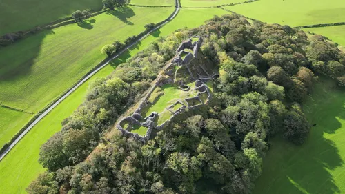
Castell y Bere Llywelyn2000 · CC BY-SA 4.0

Climate of Pen Erw-goed
Best months for sightseeingBest months for sightseeing: June–August.
This month · November
A wet month
Day 10° · Night 5° · Rain 166 mm
- Hottest month
- July (day 19°)
- Coldest month
- February (night 2°)
- Wettest month
- November (166 mm)
- Driest month
- May (80 mm)
Bars: average monthly low and high temperature. Below: precipitation. Monthly averages for 1970–2000 at about 18 km resolution, adjusted for elevation. Highlighted months are mild and relatively dry. Source: WorldClim 2.1 (CC BY 4.0).
Show values as a table
| Month | Jan | Feb | Mar | Apr | May | Jun | Jul | Aug | Sep | Oct | Nov | Dec |
|---|---|---|---|---|---|---|---|---|---|---|---|---|
| Average high (°C) | 7° | 7° | 9° | 11° | 15° | 17° | 19° | 19° | 17° | 14° | 10° | 8° |
| Average low (°C) | 2° | 2° | 3° | 4° | 7° | 10° | 12° | 12° | 10° | 7° | 5° | 3° |
| Precipitation (mm) | 149 | 109 | 129 | 90 | 80 | 93 | 94 | 112 | 124 | 151 | 166 | 161 |
How to get to Pen Erw-goed
The nearest airport is Liverpool John Lennon Airport (LPL), 103 km to the northeast as the crow flies. The nearest large city is Birkenhead, 100 km to the northeast.
Airports
- Liverpool John Lennon Airport (LPL) Liverpool 103 kmnortheast
- Manchester Airport (MAN) Manchester, Greater Manchester 135 kmnortheast
- Cardiff International Airport (CWL) Cardiff 154 kmsouth
Nearby large cities
- Birkenhead Population: 325.3K 100 kmnortheast
- Liverpool Population: 496.8K 103 kmnortheast
- Telford Population: 155.6K 105 kmeast
- St Helens Population: 183.2K 117 kmnortheast
- Warrington Population: 172.3K 121 kmnortheast
Straight-line distances; road distances are longer. Airport data: OurAirports.
Day trips from Pen Erw-goed
Within 100 km: 662 historic and cultural sites, 2,314 natural sites, 180 lakes, rivers and coasts.
0–25 km332 places
- Ynys Tywyn Island 24 kmN
- Ynys Gifftan Island 22 kmN
- Cei Ballast Island 24 kmN
- Llyn Mwyngi Lake 9 kmSE
25–60 km1,246 places
- Whistling Sands Beach 50 kmW
- Traeth Penllech Beach 48 kmW
- Porth Towyn Beach Beach 47 kmNW
- Saint Tudwals Island West Island 33 kmW
60–100 km1,578 places
- Anglesey Island 67 kmN
- Poppit Sands Beach 83 kmSW
- Mwnt beach Beach 78 kmSW
- Tresaith Beach Beach 74 kmSW
Straight-line distances.
Nearest towns and villages
-
Arthog Village, Arthog1.2 km SW
-
 Barmouth Village, Barmouth3.9 km W
-
Fairbourne Village, Arthog4.6 km SW
-
Cutiau Village, Barmouth2.3 km NW
-
Islawr-Dref Village, Arthog3.2 km E
-
Caerdeon Village, Barmouth2.5 km N
Nearby attractions & nature
Everything nearby-
Pared y Cefn-hir Mountain, Arthog1.3 km SE
-
Bryn Brith Mountain, Arthog1.4 km E
-
Pen Llynnau Cregennen Mountain, Arthog1.9 km SE
-
Ynys Dafydd Mountain, Barmouth2 km N
-
Cregennan lakes Lake, Arthog1.7 km SE
-
Craigymerwydd Mountain, Arthog2.2 km S
-
Fegla Fawr Mountain, Arthog2.2 km SW
-
Bryn y Gregennen Mountain, Arthog2.2 km SE
Sources & licences
Data last updated: