- Elevation
- 307 m
- above sea level
- Local time
- UTC+00:00
- Europe/London · UTC+00:00
- Airports
- LPL Liverpool John Lennon Airport104 km
- BHX Birmingham Airport117 km
About Rhos Fawr
Rhos Fawr is a mountain. Location: Llandinam, Powys. Elevation: 307 m. The best months to visit are June–August. The nearest airport is Liverpool John Lennon Airport (104 km). Nearby sights include Pen y Coed and Coed Mawr.
Photos of Rhos Fawr
-
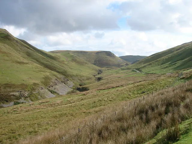
Cambrian Mountains OLU · CC BY-SA 2.0 -
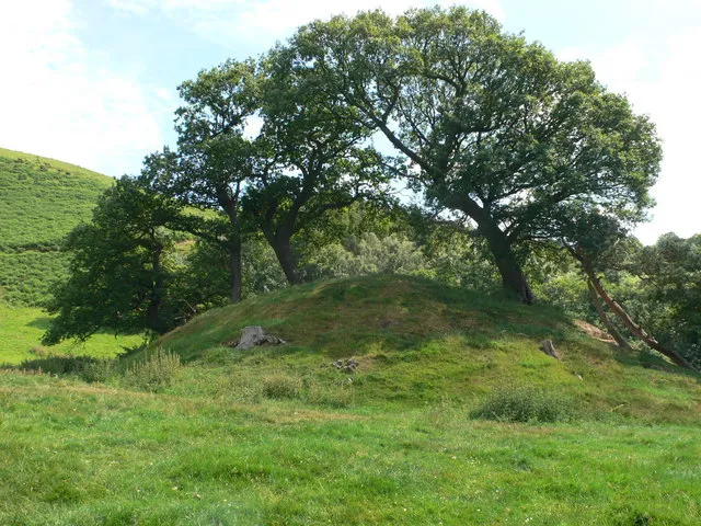
Bron Felin Motte Eirian Evans · CC BY-SA 2.0


Climate of Rhos Fawr
Best months for sightseeingBest months for sightseeing: June–August.
This month · November
A wet month
Day 9° · Night 3° · Rain 164 mm
- Hottest month
- July (day 19°)
- Coldest month
- February (night 0°)
- Wettest month
- December (178 mm)
- Driest month
- May (80 mm)
Bars: average monthly low and high temperature. Below: precipitation. Monthly averages for 1970–2000 at about 18 km resolution, adjusted for elevation. Highlighted months are mild and relatively dry. Source: WorldClim 2.1 (CC BY 4.0).
Show values as a table
| Month | Jan | Feb | Mar | Apr | May | Jun | Jul | Aug | Sep | Oct | Nov | Dec |
|---|---|---|---|---|---|---|---|---|---|---|---|---|
| Average high (°C) | 6° | 6° | 8° | 10° | 14° | 17° | 19° | 18° | 16° | 12° | 9° | 7° |
| Average low (°C) | 1° | 0° | 1° | 3° | 5° | 8° | 10° | 10° | 8° | 6° | 3° | 2° |
| Precipitation (mm) | 174 | 120 | 133 | 91 | 80 | 88 | 80 | 104 | 118 | 144 | 164 | 178 |
How to get to Rhos Fawr
The nearest airport is Liverpool John Lennon Airport (LPL), 104 km to the northeast as the crow flies. The nearest large city is Telford, 73 km to the east.
Airports
- Liverpool John Lennon Airport (LPL) Liverpool 104 kmnortheast
- Birmingham Airport (BHX) Birmingham, West Midlands 117 kmeast
- Cardiff International Airport (CWL) Cardiff 121 kmsouth
Nearby large cities
- Telford Population: 155.6K 73 kmeast
- Worcester Population: 101.7K 92 kmeast
- Wolverhampton Population: 263.7K 92 kmeast
- Dudley Population: 199.1K 95 kmeast
- West Bromwich Population: 103.1K 101 kmeast
Straight-line distances; road distances are longer. Airport data: OurAirports.
Day trips from Rhos Fawr
Within 100 km: 898 historic and cultural sites, 2,772 natural sites, 187 lakes, rivers and coasts.
0–25 km409 places
- Pen-y-gareg Reservoir Lake 23 kmSW
- Craig-yr-allt gôch Reservoir Lake 22 kmSW
- Dinas Mountain 9 kmW
- Foel Mountain 23 kmN
25–60 km1,635 places
- The Island Island 57 kmSE
- Ynys Goediog Island 54 kmN
- Lake Vyrnwy Lake 35 kmN
- Gareg-ddu Reservoir Lake 26 kmS
60–100 km1,813 places
- Poppit Sands Beach 93 kmSW
- Mwnt beach Beach 88 kmSW
- Tresaith Beach Beach 81 kmSW
- Llangrannog's Beach Beach 77 kmSW
Straight-line distances.
Nearest towns and villages
-
Llandinam Village, Llandinam2.6 km E
-
Trewythen Village, Llandinam2.1 km NE
-
Caersws Village, Caersws4.7 km NE
-
Llanidloes Village, Llanidloes5.8 km SW
-
Trefeglwys Village, Trefeglwys3.7 km NW
-
Little London Village, Llandinam4.7 km E
Nearby attractions & nature
Everything nearby-
Pen y Coed Mountain, Llandinam1.1 km NW
-
Coed Mawr Mountain, Llandinam1.8 km SE
-
Penycastell Mountain, Llanidloes Without1.8 km W
-
Cefn Carnedd Mountain, Llandinam2.3 km NE
-
Pentre Mountain, Llandinam2.8 km S
-
Cefn Mountain, Trefeglwys3.2 km N
-
Coed y Gaer Mountain, Llandinam4 km S
-
Allt y Moch Mountain, Llandinam4.1 km SE
Sources & licences
Data last updated: