- Elevation
- 378 m
- above sea level
- Local time
- UTC+00:00
- Europe/London · UTC+00:00
- Airports
- LPL Liverpool John Lennon Airport112 km
- CWL Cardiff International Airport114 km
About Craig Tylwch
Craig Tylwch is a mountain. Location: Llangurig, Powys. Elevation: 378 m. The best months to visit are July–August. The nearest airport is Liverpool John Lennon Airport (112 km). Nearby sights include Cambrian Mountains and Oldchapel Hill.
Photos of Craig Tylwch
-
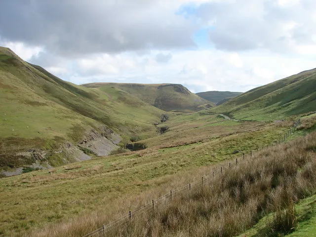
Cambrian Mountains OLU · CC BY-SA 2.0

Climate of Craig Tylwch
Best months for sightseeingBest months for sightseeing: July–August.
This month · November
A wet month
Day 8° · Night 3° · Rain 181 mm
- Hottest month
- July (day 18°)
- Coldest month
- February (night 0°)
- Wettest month
- December (195 mm)
- Driest month
- May (83 mm)
Bars: average monthly low and high temperature. Below: precipitation. Monthly averages for 1970–2000 at about 18 km resolution, adjusted for elevation. Highlighted months are mild and relatively dry. Source: WorldClim 2.1 (CC BY 4.0).
Show values as a table
| Month | Jan | Feb | Mar | Apr | May | Jun | Jul | Aug | Sep | Oct | Nov | Dec |
|---|---|---|---|---|---|---|---|---|---|---|---|---|
| Average high (°C) | 5° | 5° | 7° | 10° | 13° | 16° | 18° | 18° | 15° | 12° | 8° | 6° |
| Average low (°C) | 0° | 0° | 1° | 2° | 5° | 8° | 10° | 10° | 7° | 5° | 3° | 1° |
| Precipitation (mm) | 189 | 130 | 145 | 99 | 83 | 95 | 89 | 114 | 128 | 158 | 181 | 195 |
How to get to Craig Tylwch
The nearest airport is Liverpool John Lennon Airport (LPL), 112 km to the northeast as the crow flies. The nearest large city is Telford, 78 km to the east.
Airports
- Liverpool John Lennon Airport (LPL) Liverpool 112 kmnortheast
- Cardiff International Airport (CWL) Cardiff 114 kmsouth
- Birmingham Airport (BHX) Birmingham, West Midlands 121 kmeast
Nearby large cities
- Telford Population: 155.6K 78 kmeast
- Worcester Population: 101.7K 92 kmeast
- Swansea Population: 300.4K 93 kmsouth
- Wolverhampton Population: 263.7K 97 kmeast
- Dudley Population: 199.1K 98 kmeast
Straight-line distances; road distances are longer. Airport data: OurAirports.
Day trips from Craig Tylwch
Within 100 km: 949 historic and cultural sites, 2,816 natural sites, 194 lakes, rivers and coasts.
0–25 km411 places
- Pen-y-gareg Reservoir Lake 14 kmSW
- Gareg-ddu Reservoir Lake 17 kmS
- Dol-y-mynach Reservoir Lake 21 kmS
- Craig-yr-allt gôch Reservoir Lake 13 kmSW
25–60 km1,624 places
- The Island Island 57 kmE
- Lake Vyrnwy Lake 43 kmN
- Llangorse Lake Lake 57 kmS
- Bala Lake Lake 53 kmN
60–100 km1,924 places
- Poppit Sands Beach 87 kmSW
- Mwnt beach Beach 83 kmW
- Tresaith Beach Beach 75 kmSW
- Llangrannog's Beach Beach 71 kmSW
Straight-line distances.
Nearest towns and villages
-
Tylwch Village, Llangurig0.9 km SE
-
Llanidloes Village, Llanidloes4 km N
-
Cwmbelan Village, Llangurig2.4 km W
-
Felindre Neighbourhood, Llangurig3.8 km NW
-
Llanidloes Municipality, Powys4 km N
-
Nantgwyn Village, St. Harmon4.4 km S
Nearby attractions & nature
Everything nearby-
Cambrian Mountains Mountain, Wales1.5 km E
-
Oldchapel Hill Mountain, Llandinam1 km E
-
Bryn Nant Cae-garw Mountain, Llangurig1.1 km SW
-
Brynposteg Hill Mountain, Llangurig1.5 km NW
-
Bryn Mawr Mountain, Llangurig2.2 km W
-
Wennallt Mountain, St. Harmon2.4 km S
-
Graig Iar Mountain, Llandinam2.7 km E
-
Pant-poeth Hill Mountain, Llandinam3 km E
Sources & licences
Data last updated: