- Elevation
- 663 m
- above sea level
- Local time
- UTC+00:00
- Europe/London · UTC+00:00
- Airports
- CWL Cardiff International Airport62 km
- BRS Bristol Airport70 km
About Mynydd Llysiau
Mynydd Llysiau is a mountain. Location: Talgarth, Powys. Elevation: 663 m. The best months to visit are July–August. The nearest airport is Cardiff International Airport (62 km). Nearby sights include Waun Fach and Pen Twyn Glas.
Photos of Mynydd Llysiau
-
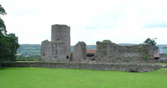
Tretower Castle Pete Chapman · CC BY-SA 2.0

Climate of Mynydd Llysiau
Best months for sightseeingBest months for sightseeing: July–August.
This month · November
A wet month
Day 7° · Night 1° · Rain 143 mm
- Hottest month
- July (day 17°)
- Coldest month
- February (night -2°)
- Wettest month
- December (155 mm)
- Driest month
- July (70 mm)
Bars: average monthly low and high temperature. Below: precipitation. Monthly averages for 1970–2000 at about 18 km resolution, adjusted for elevation. Highlighted months are mild and relatively dry. Source: WorldClim 2.1 (CC BY 4.0).
Show values as a table
| Month | Jan | Feb | Mar | Apr | May | Jun | Jul | Aug | Sep | Oct | Nov | Dec |
|---|---|---|---|---|---|---|---|---|---|---|---|---|
| Average high (°C) | 4° | 3° | 6° | 8° | 12° | 15° | 17° | 17° | 14° | 10° | 7° | 5° |
| Average low (°C) | -1° | -2° | 0° | 1° | 4° | 7° | 9° | 9° | 7° | 4° | 1° | 0° |
| Precipitation (mm) | 154 | 110 | 115 | 86 | 82 | 83 | 70 | 97 | 112 | 129 | 143 | 155 |
How to get to Mynydd Llysiau
The nearest airport is Cardiff International Airport (CWL), 62 km to the south as the crow flies. The nearest large city is Newport, 41 km to the south.
Airports
- Cardiff International Airport (CWL) Cardiff 62 kmsouth
- Bristol Airport (BRS) Bristol 70 kmsoutheast
- Birmingham Airport (BHX) Birmingham, West Midlands 112 kmnortheast
Nearby large cities
- Newport Population: 161.5K 41 kmsouth
- Cardiff Population: 372.1K 52 kmsouth
- Gloucester Population: 132.4K 63 kmeast
- Swansea Population: 300.4K 65 kmsouthwest
- Bristol Population: 479K 67 kmsoutheast
Straight-line distances; road distances are longer. Airport data: OurAirports.
Day trips from Mynydd Llysiau
Within 100 km: 1,027 historic and cultural sites, 2,353 natural sites, 160 lakes, rivers and coasts.
0–25 km295 places
- Llangorse Lake Lake 8 kmW
- Talybont Reservoir Lake 14 kmSW
- Pen y Fan Mountain 21 kmW
- Sugar Loaf Mountain 11 kmSE
25–60 km1,392 places
- Denny Island Island 53 kmSE
- The Island Island 46 kmNE
- Pen-y-gareg Reservoir Lake 51 kmNW
- Lisvane Reservoir Lake 46 kmS
60–100 km1,853 places
- Kilve Beach Beach 84 kmS
- Tresaith Beach Beach 96 kmW
- Llangrannog's Beach Beach 93 kmW
- Ynys Lochtyn Island 93 kmW
Straight-line distances.
Nearest towns and villages
-
Pengenffordd Village, Talgarth4 km NW
-
 Capel-y-ffin Village, Llanigon6 km NE
-
Talgarth Village, Talgarth7.8 km NW
-
Cwmrhos Village, Llanfihangel Cwmdu with Bwlch and Cathedine3.8 km SW
-
Penisha Rhos Village, Talgarth5 km NW
-
The Vale of Grwyney Municipality, Powys5.1 km SE
Nearby attractions & nature
Everything nearby-
Waun Fach Mountain, The Vale of Grwyney2.2 km N
-
Pen Twyn Glas Mountain, Llanfihangel Cwmdu with Bwlch and Cathedine2.3 km S
-
Pen y Gader-fawr Mountain, The Vale of Grwyney2.7 km E
-
Pen y Grib Mountain, Talgarth3.5 km NW
-
Castell Dinas Mountain, Talgarth3.6 km NW
-
Black Mountains Mountain, Wales3.6 km NE
-
Pen Allt-mawr Mountain, Llanfihangel Cwmdu with Bwlch and Cathedine3.6 km S
-
Pen Twyn Mawr Mountain, The Vale of Grwyney3.7 km E
Sources & licences
Data last updated: