Sankt Leonhard am Hornerwald
Located in Politischer Bezirk Krems, Lower Austria Coordinates: 48°35′16″ N 15°33′42″ E
- Population
- 1,136
- 1.1K
- Elevation
- 546 m
- above sea level
- Local time
- UTC+01:00
- Europe/Vienna · UTC+01:00
- Places inside
- 9
- listed under Sankt Leonhard am Hornerwald
- Airports
- VIE Vienna International Airport92 km
- JCL České Budějovice South Bohemian Airport92 km
About Sankt Leonhard am Hornerwald
Sankt Leonhard am Hornerwald is a municipality. Location: Politischer Bezirk Krems, Lower Austria. Population: 1,136. Elevation: 546 m. The best months to visit are June–August. The nearest airport is Vienna International Airport (92 km). Nearby sights include Ulrichsberg and Rosenburg castle.
Photos of Sankt Leonhard am Hornerwald
-
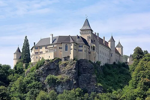
Rosenburg castle C.Stadler/Bwag · CC BY-SA 4.0

Climate of Sankt Leonhard am Hornerwald
Best months for sightseeingBest months for sightseeing: June–August.
This month · November
A cold month
Day 5° · Night -1° · Rain 44 mm
- Hottest month
- July (day 22°)
- Coldest month
- January (night -6°)
- Wettest month
- June (87 mm)
- Driest month
- January (26 mm)
Bars: average monthly low and high temperature. Below: precipitation. Monthly averages for 1970–2000 at about 18 km resolution, adjusted for elevation. Highlighted months are mild and relatively dry. Source: WorldClim 2.1 (CC BY 4.0).
Show values as a table
| Month | Jan | Feb | Mar | Apr | May | Jun | Jul | Aug | Sep | Oct | Nov | Dec |
|---|---|---|---|---|---|---|---|---|---|---|---|---|
| Average high (°C) | 1° | 2° | 7° | 12° | 17° | 20° | 22° | 22° | 17° | 12° | 5° | 2° |
| Average low (°C) | -6° | -5° | -2° | 2° | 7° | 10° | 12° | 11° | 8° | 3° | -1° | -4° |
| Precipitation (mm) | 26 | 28 | 36 | 47 | 67 | 87 | 86 | 70 | 49 | 36 | 44 | 34 |
How to get to Sankt Leonhard am Hornerwald
The nearest airport is Vienna International Airport (VIE), 92 km to the southeast as the crow flies. The nearest large city is Linz, 99 km to the west.
Airports
- Vienna International Airport (VIE) Vienna 92 kmsoutheast
- České Budějovice South Bohemian Airport (JCL) České Budějovice 92 kmnorthwest
- Brno-Tuřany Airport (BRQ) Brno 104 kmnortheast
Nearby large cities
- Linz Population: 204.8K 99 kmwest
- Brno Population: 404.3K 102 kmnortheast
- Bratislava Population: 423.7K 124 kmsoutheast
- Graz Population: 303.3K 169 kmsouth
- Győr Population: 129.3K 184 kmsoutheast
Straight-line distances; road distances are longer. Airport data: OurAirports.
Day trips from Sankt Leonhard am Hornerwald
Within 100 km: 512 historic and cultural sites, 1,995 natural sites, 485 lakes, rivers and coasts.
0–25 km121 places
- Steinberg Mountain 23 kmN
- Spielberg Mountain 25 kmSE
- Goldberg Mountain 24 kmSE
- Eisenhut Mountain 23 kmSE
25–60 km1,011 places
- Gassner Camel Riding School Natural site 42 kmSW
- Waldsee Lake 43 kmSE
- Waldbad Lake 58 kmE
- Kranbühel Mountain 36 kmNW
60–100 km1,860 places
- Královský vršek Mountain 92 kmN
- Gusen I Concentration Camp Historic site 89 kmSW
- Donauinsel Island 82 kmSE
- Vienna Forest Lake Lake 61 kmSE
Straight-line distances.
Places in Sankt Leonhard am Hornerwald
9 places- 1 Wolfshoferamt 510
- 2 Sankt Leonhard am Hornerwald 316
- 3 Obertautendorferamt 112
- 4 Untertautendorferamt 111
- 5 Wilhalm 70
Bar: population relative to the most populous place in this list.
Cities & villages2
- Palt · Village
- Tautendorf · Village
Mountains & nature1
- Hogmannriegel · Mountain
Heritage & sights1
- Schauenstein · Historic site
Nearby attractions & nature
Everything nearby-
Ulrichsberg Mountain, Jaidhof4.2 km S
-
Rosenburg castle Historic site, Rosenburg-Mold6.9 km NE
-
Horner Wald Natural site, Lower Austria4.6 km NW
-
Reisingerhöhe Mountain, Gföhl5.4 km SW
-
Buch Berg Mountain, Pölla6 km NW
-
Fran Bach River, Lower Austria5.6 km NW
-
Bruchet Bach River, Lower Austria5.6 km NW
-
Töpenitz Bach River, Lower Austria5.9 km W
Sources & licences
Data last updated: