Weinberg
Located in Nussbach, Politischer Bezirk Kirchdorf an der Krems Coordinates: 47°57′35″ N 14°08′47″ E
- Elevation
- 522 m
- above sea level
- Local time
- UTC+01:00
- Europe/Vienna · UTC+01:00
- Airports
- LNZ Linz-Hörsching Airport31 km
- SZG Salzburg Airport87 km
About Weinberg
Weinberg is a village. Location: Nussbach, Politischer Bezirk Kirchdorf an der Krems. Elevation: 522 m. The best months to visit are June–September. The nearest airport is Linz-Hörsching Airport (31 km). Nearby sights include Grillenparz and Klein Raming Tal.
Photos of Weinberg
-
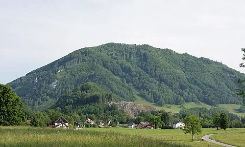
Großer Landsberg Christoph Waghubinger · CC BY-SA 3.0 at -
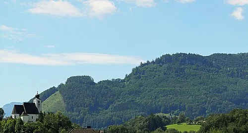
Kleiner Landsberg Christoph Waghubinger · CC BY-SA 4.0


Climate of Weinberg
Best months for sightseeingBest months for sightseeing: June–September.
This month · November
A cold month
Day 6° · Night 0° · Rain 77 mm
- Hottest month
- July (day 23°)
- Coldest month
- January (night -4°)
- Wettest month
- July (144 mm)
- Driest month
- February (60 mm)
Bars: average monthly low and high temperature. Below: precipitation. Monthly averages for 1970–2000 at about 18 km resolution, adjusted for elevation. Highlighted months are mild and relatively dry. Source: WorldClim 2.1 (CC BY 4.0).
Show values as a table
| Month | Jan | Feb | Mar | Apr | May | Jun | Jul | Aug | Sep | Oct | Nov | Dec |
|---|---|---|---|---|---|---|---|---|---|---|---|---|
| Average high (°C) | 2° | 4° | 8° | 12° | 18° | 21° | 23° | 23° | 18° | 13° | 6° | 3° |
| Average low (°C) | -4° | -4° | 0° | 3° | 8° | 11° | 13° | 13° | 9° | 5° | 0° | -3° |
| Precipitation (mm) | 66 | 60 | 82 | 76 | 92 | 126 | 144 | 117 | 91 | 70 | 77 | 79 |
Other places to visit in this season: June July August September
How to get to Weinberg
The nearest airport is Linz-Hörsching Airport (LNZ), 31 km to the north as the crow flies. The nearest large city is Linz, 40 km to the north.
Airports
- Linz-Hörsching Airport (LNZ) Linz 31 kmnorth
- Salzburg Airport (SZG) Salzburg 87 kmwest
- České Budějovice South Bohemian Airport (JCL) České Budějovice 112 kmnorth
Nearby large cities
- Linz Population: 204.8K 40 kmnorth
- Salzburg Population: 157.2K 84 kmwest
- Graz Population: 303.3K 139 kmsoutheast
- Klagenfurt Population: 100.3K 149 kmsouth
- Regensburg Population: 151.4K 191 kmnorthwest
Straight-line distances; road distances are longer. Airport data: OurAirports.
Day trips from Weinberg
Within 100 km: 274 historic and cultural sites, 2,480 natural sites, 831 lakes, rivers and coasts.
0–25 km175 places
- Laudachsee Lake 24 kmW
- Kleiner Öden See Lake 24 kmSW
- Feichtauer Seen Lake 22 kmSE
- Großer Ödsee Lake 24 kmSW
25–60 km1,210 places
- Klamm Natural site 51 kmS
- Gusen I Concentration Camp Historic site 41 kmNE
- Treffnersee Lake 56 kmSE
- Glohbuckensee Lake 55 kmS
60–100 km2,200 places
- Hoher Dachstein Mountain 67 kmSW
- Gassner Camel Riding School Natural site 91 kmE
- Seeriessee Lake 74 kmSW
- Untersee Lake 79 kmSW
Straight-line distances.
Nearby attractions & nature
Everything nearby-
Grillenparz Mountain, Oberschlierbach4.5 km S
-
Klein Raming Tal Natural site, Austria4.8 km NE
-
Großer Landsberg Mountain, Grünburg7.4 km SE
-
Kleiner Landsberg Mountain, Grünburg7.6 km SE
-
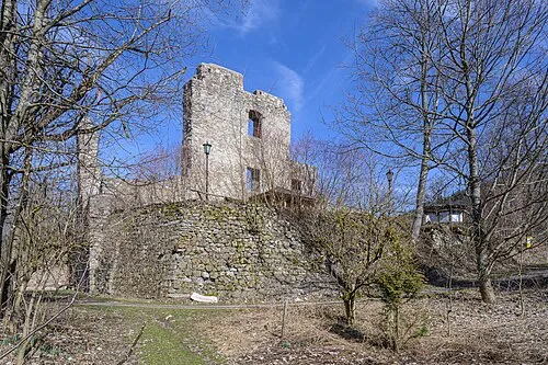 Schloss Seisenburg Historic site, Inzersdorf im Kremstal8.6 km SW
-
Pernecker Kogel Mountain, Steinbach am Ziehberg9.1 km SW
Sources & licences
Data last updated: