Forêt de Taillard
Located in Ardèche, Auvergne-Rhône-Alpes Coordinates: 45°15′16″ N 4°29′27″ E
- Elevation
- 1,058 m
- above sea level
- Local time
- UTC+01:00
- Europe/Paris · UTC+01:00
- Airports
- GNB Grenoble Alpes Isère Airport67 km
- LYS Lyon Saint-Exupéry Airport70 km
About Forêt de Taillard
Forêt de Taillard is a natural site. Location: Ardèche, Auvergne-Rhône-Alpes. The best months to visit are July–August. The nearest airport is Grenoble Alpes Isère Airport (67 km). Nearby sights include Les Cimes ou le Planel and Pyfara.
Photos of Forêt de Taillard
-
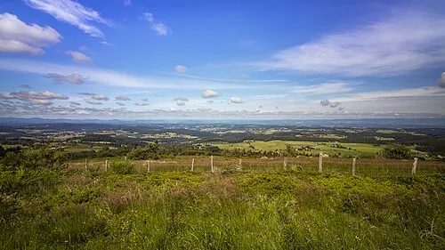
Chaussitre Sandrine Néel · CC BY 2.0

Climate of Forêt de Taillard
Best months for sightseeingBest months for sightseeing: July–August.
This month · November
A cold month
Day 7° · Night 0° · Rain 94 mm
- Hottest month
- July (day 22°)
- Coldest month
- January (night -3°)
- Wettest month
- October (111 mm)
- Driest month
- February (63 mm)
Bars: average monthly low and high temperature. Below: precipitation. Monthly averages for 1970–2000 at about 18 km resolution, adjusted for elevation. Highlighted months are mild and relatively dry. Source: WorldClim 2.1 (CC BY 4.0).
Show values as a table
| Month | Jan | Feb | Mar | Apr | May | Jun | Jul | Aug | Sep | Oct | Nov | Dec |
|---|---|---|---|---|---|---|---|---|---|---|---|---|
| Average high (°C) | 3° | 4° | 7° | 9° | 14° | 18° | 22° | 21° | 17° | 12° | 7° | 4° |
| Average low (°C) | -3° | -2° | -1° | 1° | 5° | 8° | 11° | 11° | 8° | 5° | 0° | -2° |
| Precipitation (mm) | 77 | 63 | 71 | 88 | 109 | 90 | 69 | 82 | 102 | 111 | 94 | 79 |
How to get to Forêt de Taillard
The nearest airport is Grenoble Alpes Isère Airport (GNB), 67 km to the east as the crow flies. For international flights: Lyon Saint-Exupéry Airport (LYS) (70 km). The nearest large city is Saint-Etienne, 21 km to the north.
Airports
- Grenoble Alpes Isère Airport (GNB) Grenoble 67 kmeast
- Lyon Saint-Exupéry Airport (LYS) Colombier-Saugnieu, Rhône 70 kmnortheast
- Chambéry Aix les Bains airport (CMF) Chambéry 117 kmeast
Nearby large cities
- Saint-Etienne Population: 176.3K 21 kmnorth
- Lyon Population: 520.8K 62 kmnortheast
- Villeurbanne Population: 131.4K 64 kmnortheast
- Grenoble Population: 158.6K 97 kmeast
- Clermont-Ferrand Population: 147.9K 124 kmnorthwest
Straight-line distances; road distances are longer. Airport data: OurAirports.
Day trips from Forêt de Taillard
Within 100 km: 173 historic and cultural sites, 744 natural sites, 233 lakes, rivers and coasts.
0–25 km98 places
- La Chaux de l'Égalet Mountain 19 kmNE
- le Bois Paradis Mountain 15 kmNE
- Montjay Mountain 25 kmS
- Chantelermuse Mountain 21 kmSE
25–60 km343 places
- Lac d'Issarlès Lake 59 kmSW
- Réservoir de Couzon Lake 29 kmN
- La Courbe Mountain 59 kmS
- Mont Plaux Mountain 42 kmSW
60–100 km709 places
- Alba-la-Romaine (Ardèche, France) -- Théâtre gallo-romain Historic site 78 kmS
- Parc de la Tête d'Or Natural site 65 kmNE
- Puy Bien Mountain 83 kmNW
- Îles Margeries Island 94 kmS
Straight-line distances.
Nearest towns and villages
-
Saint-Sauveur-en-Rue Village, Arrondissement of Saint-Étienne1.7 km N
-
Saint-Sauveur-en-Rue Village, Saint-Sauveur-en-Rue1.7 km N
-
Saint-Régis-du-Coin Village, Arrondissement of Saint-Étienne4.9 km NW
-
Poutette Village, Saint-Sauveur-en-Rue2.4 km NE
-
Vanosc Village, Arrondissement de Tournon-sur-Rhône5.8 km SE
-
Saint-Régis-du-Coin Village, Saint-Régis-du-Coin4.8 km NW
Nearby attractions & nature
Everything nearby-
Les Cimes ou le Planel Mountain, Burdignes1.2 km SE
-
Pyfara Mountain, Burdignes2.1 km S
-
Chaussitre Mountain, Saint-Régis-du-Coin6.7 km NW
-
Petit Felletin Mountain, Saint-Julien-Molhesabate6 km S
-
Grand Felletin Mountain, Monestier6.6 km S
-
Bois Panère Natural site, Loire5 km NW
-
Suc de Servaux Mountain, Monestier7.1 km S
-
Parc du Pilat Natural site, Ardèche7.3 km E
Sources & licences
Data last updated: