- Elevation
- 1,284 m
- above sea level
- Local time
- UTC+01:00
- Europe/Paris · UTC+01:00
- Airports
- AVN Avignon Caumont airport88 km
- GNB Grenoble Alpes Isère Airport99 km
About Serre Charomp
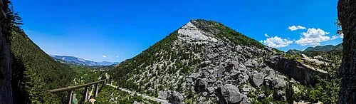
Serre Charomp is a mountain. Location: Drôme, Auvergne-Rhône-Alpes. Elevation: 1,284 m. The best months to visit are July–August. The nearest airport is Avignon Caumont airport (88 km). Nearby sights include Roc de Beauvent and Sommet de Laup.
Climate of Serre Charomp
Best months for sightseeingBest months for sightseeing: July–August.
This month · November
A wet month
Day 7° · Night -1° · Rain 118 mm
- Hottest month
- July (day 23°)
- Coldest month
- January (night -5°)
- Wettest month
- November (118 mm)
- Driest month
- July (49 mm)
Bars: average monthly low and high temperature. Below: precipitation. Monthly averages for 1970–2000 at about 18 km resolution, adjusted for elevation. Highlighted months are mild and relatively dry. Source: WorldClim 2.1 (CC BY 4.0).
Show values as a table
| Month | Jan | Feb | Mar | Apr | May | Jun | Jul | Aug | Sep | Oct | Nov | Dec |
|---|---|---|---|---|---|---|---|---|---|---|---|---|
| Average high (°C) | 4° | 5° | 8° | 10° | 15° | 19° | 23° | 23° | 18° | 13° | 7° | 4° |
| Average low (°C) | -5° | -4° | -2° | 0° | 4° | 8° | 10° | 10° | 7° | 4° | -1° | -3° |
| Precipitation (mm) | 86 | 69 | 77 | 87 | 101 | 82 | 49 | 77 | 99 | 114 | 118 | 94 |
How to get to Serre Charomp
The nearest airport is Avignon Caumont airport (AVN), 88 km to the southwest as the crow flies. For international flights: Marseille Provence Airport (MRS) (122 km). The nearest large city is Grenoble, 76 km to the north.
Airports
- Avignon Caumont airport (AVN) Avignon 88 kmsouthwest
- Grenoble Alpes Isère Airport (GNB) Grenoble 99 kmnorth
- Marseille Provence Airport (MRS) Marignane, Bouches-du-Rhône 122 kmsouth
Nearby large cities
- Grenoble Population: 158.6K 76 kmnorth
- Aix-en-Provence Population: 146.8K 109 kmsouth
- Nîmes Population: 148.2K 125 kmsouthwest
- Marseille Population: 877.2K 135 kmsouth
- Saint-Etienne Population: 176.3K 143 kmnorthwest
Straight-line distances; road distances are longer. Airport data: OurAirports.
Nearest towns and villages
-
La Bâtie-des-Fonds Village, Arrondissement de Die2.1 km NE
-
La Bâtie-des-Fonds Village, La Bâtie-des-Fonds2 km NE
-
La Piarre Village, Arrondissement of Gap3.3 km SE
-
La Piarre Village, La Piarre3.3 km SE
-
Valdrôme Village, Arrondissement de Die4.4 km W
-
Valdrôme Village, Valdrôme4.3 km W
Nearby attractions & nature
Everything nearby-
Roc de Beauvent Mountain, Hautes-Alpes2.8 km NE
-
Sommet de Laup Mountain, La Beaume4 km N
-
Banne Mountain, Auvergne-Rhône-Alpes4.2 km N
-
Le Duffre [Montagne de l'Aup] Mountain, Drôme4 km SW
-
Montagne de Peyre-Grosse Mountain, Drôme6.3 km W
-
Montagne de Dindaret Mountain, Valdrôme6.7 km W
-
Montagne l'Archier Mountain, Hautes-Alpes5.7 km NW
-
Montagne de Chauvet Mountain, L'Épine7.6 km SW
More nature in France
-
Montagne de Tarsimoure Mountain, Valdrôme9.2 km W
-
Roc de Coulobre Mountain, Val-Maravel10 km N
-
Montagne Chauvet Mountain, Val-Maravel11 km N
-
Pierre Blanche Mountain, Val-Maravel12 km N
-
 Pic de Luc Mountain, Luc-en-Diois18 km NW
-
Montagne du Puy Mountain, Lesches-en-Diois14 km NW
Sources & licences
Data last updated: · 2 independent sources