Le Châtel
Located in Val-Cenis, Arrondissement of Saint-Jean-de-Maurienne Coordinates: 45°14′31″ N 6°47′38″ E
- Elevation
- 1,241 m
- above sea level
- Local time
- UTC+01:00
- Europe/Paris · UTC+01:00
- Airports
- TRN Turin Airport67 km
- CMF Chambéry Aix les Bains airport84 km
About Le Châtel
Le Châtel is a village. Location: Val-Cenis, Arrondissement of Saint-Jean-de-Maurienne. Elevation: 1,241 m. The best months to visit are July–August. The nearest airport is Turin Airport (67 km). Nearby sights include Mont Froid and Ruisseau d'Ambin.
Photos of Le Châtel
-
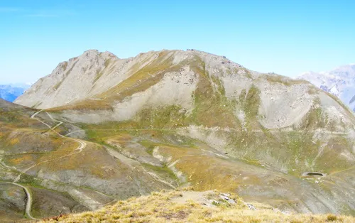
Mont Froid Pampuco · CC BY-SA 4.0

Climate of Le Châtel
Best months for sightseeingBest months for sightseeing: July–August.
This month · November
A wet month
Day 7° · Night 2° · Rain 144 mm
- Hottest month
- August (day 21°)
- Coldest month
- January (night -3°)
- Wettest month
- November (144 mm)
- Driest month
- July (75 mm)
Bars: average monthly low and high temperature. Below: precipitation. Monthly averages for 1970–2000 at about 18 km resolution, adjusted for elevation. Highlighted months are mild and relatively dry. Source: WorldClim 2.1 (CC BY 4.0).
Show values as a table
| Month | Jan | Feb | Mar | Apr | May | Jun | Jul | Aug | Sep | Oct | Nov | Dec |
|---|---|---|---|---|---|---|---|---|---|---|---|---|
| Average high (°C) | 3° | 4° | 5° | 8° | 13° | 17° | 21° | 21° | 18° | 13° | 7° | 5° |
| Average low (°C) | -3° | -3° | -1° | 1° | 5° | 9° | 12° | 13° | 10° | 6° | 2° | -1° |
| Precipitation (mm) | 128 | 119 | 114 | 117 | 118 | 97 | 75 | 87 | 95 | 128 | 144 | 134 |
How to get to Le Châtel
The nearest airport is Turin Airport (TRN), 67 km to the east as the crow flies. The nearest large city is Grenoble, 85 km to the west.
Airports
- Turin Airport (TRN) Caselle Torinese (TO) 67 kmeast
- Chambéry Aix les Bains airport (CMF) Chambéry 84 kmnorthwest
- Annecy Meythet airport (NCY) Annecy 94 kmnorthwest
Nearby large cities
- Grenoble Population: 158.6K 85 kmwest
- Geneva Population: 201.7K 118 kmnorthwest
- Lausanne Population: 139.1K 142 kmnorth
- Villeurbanne Population: 131.4K 161 kmwest
- Lyon Population: 520.8K 162 kmwest
Straight-line distances; road distances are longer. Airport data: OurAirports.
Day trips from Le Châtel
Within 100 km: 97 historic and cultural sites, 1,907 natural sites, 287 lakes, rivers and coasts.
0–25 km179 places
- Lac des Vaches Lake 17 kmN
- Lac Rond Lake 16 kmN
- Lac du Mont Cenis Lake 11 kmE
- Lac Long Lake 17 kmN
25–60 km598 places
- Lacs de la Tempête Lake 47 kmNW
- Lac de la Plagne Lake 27 kmN
- Lac de Néal Lake 52 kmS
- Lac de la Motte Lake 56 kmW
60–100 km1,514 places
- Lac Mort Lake 82 kmW
- Lac d'Émosson Lake 94 kmN
- Lac d'Orny Lake 87 kmN
- Lac de la Breye Lake 90 kmN
Straight-line distances.
Nearby attractions & nature
Everything nearby-
Mont Froid Mountain, Val-Cenis3.9 km E
-
Ruisseau d'Ambin River, Val-Cenis2.3 km SW
-
Saint-Pierre d'Extravache Landmark, Val-Cenis2.8 km S
-
Signal du Petit-Mont-Cenis Mountain, Val-Cenis6.3 km E
-
Ruisseau du Doron River, Val-Cenis4.8 km N
-
Fort Charles-Albert Historic site, Aussois4.6 km SW
Sources & licences
Data last updated: