- Elevation
- 941 m
- above sea level
- Local time
- UTC+01:00
- Europe/Paris · UTC+01:00
- Airports
- CMF Chambéry Aix les Bains airport53 km
- NCY Annecy Meythet airport64 km
About Nantbrun
Nantbrun is a river. Location: Savoy, Auvergne-Rhône-Alpes. The best months to visit are July–August. The nearest airport is Chambéry Aix les Bains airport (53 km). Nearby sights include Roc de Fer and Pointe de Crève-Tête.
Photos of Nantbrun
-
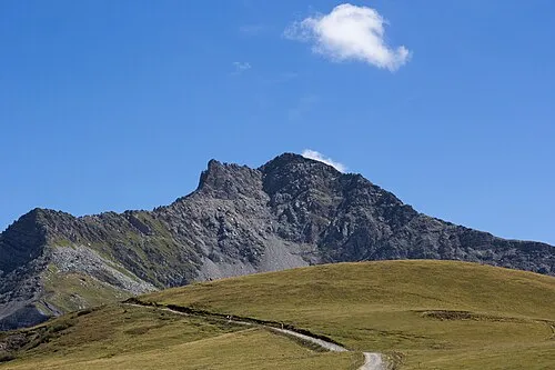
Le Cheval Noir Poudou99 · CC BY-SA 3.0

Climate of Nantbrun
Best months for sightseeingBest months for sightseeing: July–August.
This month · November
A wet month
Day 9° · Night 3° · Rain 156 mm
- Hottest month
- August (day 24°)
- Coldest month
- January (night -2°)
- Wettest month
- November (156 mm)
- Driest month
- July (85 mm)
Bars: average monthly low and high temperature. Below: precipitation. Monthly averages for 1970–2000 at about 18 km resolution, adjusted for elevation. Highlighted months are mild and relatively dry. Source: WorldClim 2.1 (CC BY 4.0).
Show values as a table
| Month | Jan | Feb | Mar | Apr | May | Jun | Jul | Aug | Sep | Oct | Nov | Dec |
|---|---|---|---|---|---|---|---|---|---|---|---|---|
| Average high (°C) | 5° | 6° | 8° | 10° | 16° | 20° | 23° | 24° | 20° | 15° | 9° | 6° |
| Average low (°C) | -2° | -1° | 1° | 3° | 7° | 10° | 13° | 14° | 11° | 7° | 3° | 0° |
| Precipitation (mm) | 137 | 131 | 118 | 117 | 124 | 109 | 85 | 95 | 105 | 134 | 156 | 149 |
How to get to Nantbrun
The nearest airport is Chambéry Aix les Bains airport (CMF), 53 km to the northwest as the crow flies. The nearest large city is Grenoble, 67 km to the southwest.
Airports
- Chambéry Aix les Bains airport (CMF) Chambéry 53 kmnorthwest
- Annecy Meythet airport (NCY) Annecy 64 kmnorthwest
- Grenoble Alpes Isère Airport (GNB) Grenoble 91 kmwest
Nearby large cities
- Grenoble Population: 158.6K 67 kmsouthwest
- Geneva Population: 201.7K 91 kmnorth
- Lausanne Population: 139.1K 122 kmnorth
- Villeurbanne Population: 131.4K 131 kmwest
- Lyon Population: 520.8K 133 kmwest
Straight-line distances; road distances are longer. Airport data: OurAirports.
Day trips from Nantbrun
Within 100 km: 119 historic and cultural sites, 2,143 natural sites, 336 lakes, rivers and coasts.
0–25 km190 places
- Lac des Vaches Lake 23 kmE
- Lacs de la Tempête Lake 22 kmN
- Lac Rond Lake 25 kmE
- Lac Long Lake 24 kmE
25–60 km756 places
- St Alban Plage Beach 56 kmW
- Plage de Menthon Saint Bernard Beach 54 kmNW
- Plage d'Albigny Beach 60 kmNW
- Plage St Jorioz Beach 53 kmNW
60–100 km1,652 places
- Lac Mort Lake 70 kmSW
- Lac de Fully Lake 96 kmNE
- Lac d'Émosson Lake 81 kmNE
- Lac Sup. de Fully Lake 96 kmNE
Straight-line distances.
Nearest towns and villages
-
Saint-Jean-de-Belleville Village, Les Belleville0.6 km NW
-
Planvillard Village, Les Belleville0.6 km SE
-
Saint-Laurent-de-la-Côte Village, Les Belleville0.9 km NE
-
Les Belleville Village, Arrondissement of Albertville4.8 km S
-
La Flachère Village, Les Belleville1.3 km SW
-
La Combe Village, Les Belleville1.4 km S
Nearby attractions & nature
Everything nearby-
Roc de Fer Mountain, Les Belleville3.9 km SE
-
Pointe de Crève-Tête Mountain, Les Avanchers-Valmorel3.6 km NW
-
Torrent des Encombres River, Savoy4.2 km S
-
Le Cheval Noir Mountain, Les Belleville6 km W
-
Doron de Belleville River, Savoy5 km NE
-
Montagne de Cherferie Mountain, Les Allues5 km SE
-
Pointe du Mottet Mountain, Les Belleville5.9 km W
-
Torrent Doron de Bozel River, Savoy6 km NE
Sources & licences
Data last updated: