Courcelles-lès-Montbard
Located in Arrondissement de Montbard, Cote d'Or Coordinates: 47°35′37″ N 4°23′51″ E
- Population
- 77
- 77
- Elevation
- 249 m
- above sea level
- Local time
- UTC+01:00
- Europe/Paris · UTC+01:00
- Places inside
- 1
- listed under Courcelles-lès-Montbard
- Airports
- DLE Dole Tavaux Airport99 km
- XCR Chalons Vatry airport132 km
About Courcelles-lès-Montbard
Courcelles-lès-Montbard is a village. Location: Arrondissement de Montbard, Cote d'Or. Population: 77. Elevation: 249 m. The best months to visit are June–September. The nearest airport is Dole Tavaux Airport (99 km). Nearby sights include Abbey of Fontenay and Bois de Fains.
Photos of Courcelles-lès-Montbard
-
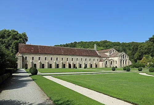
Abbey of Fontenay Marc Ryckaert · CC BY-SA 4.0

Climate of Courcelles-lès-Montbard
Best months for sightseeingBest months for sightseeing: June–September.
This month · November
A cold month
Day 9° · Night 2° · Rain 84 mm
- Hottest month
- July (day 25°)
- Coldest month
- February (night -1°)
- Wettest month
- December (85 mm)
- Driest month
- July (59 mm)
Bars: average monthly low and high temperature. Below: precipitation. Monthly averages for 1970–2000 at about 18 km resolution, adjusted for elevation. Highlighted months are mild and relatively dry. Source: WorldClim 2.1 (CC BY 4.0).
Show values as a table
| Month | Jan | Feb | Mar | Apr | May | Jun | Jul | Aug | Sep | Oct | Nov | Dec |
|---|---|---|---|---|---|---|---|---|---|---|---|---|
| Average high (°C) | 5° | 7° | 11° | 13° | 18° | 21° | 25° | 25° | 20° | 15° | 9° | 6° |
| Average low (°C) | 0° | -1° | 2° | 4° | 8° | 11° | 13° | 13° | 10° | 7° | 2° | 1° |
| Precipitation (mm) | 77 | 71 | 65 | 64 | 81 | 72 | 59 | 75 | 69 | 70 | 84 | 85 |
Other places to visit in this season: June July August September
How to get to Courcelles-lès-Montbard
The nearest airport is Dole Tavaux Airport (DLE), 99 km to the southeast as the crow flies. For international flights: Paris-Orly Airport (ORY) (197 km). The nearest large city is Dijon, 56 km to the southeast.
Airports
- Dole Tavaux Airport (DLE) Dole 99 kmsoutheast
- Chalons Vatry airport (XCR) Chalons en Champagne 132 kmnorth
- Paris-Orly Airport (ORY) Paris (Orly, Val-de-Marne) 197 kmnorthwest
Nearby large cities
- Dijon Population: 159.9K 56 kmsoutheast
- Besançon Population: 128.4K 128 kmeast
- Nancy Population: 105.1K 180 kmnortheast
- Reims Population: 196.6K 188 kmnorth
- Orléans Population: 116.3K 190 kmwest
Straight-line distances; road distances are longer. Airport data: OurAirports.
Day trips from Courcelles-lès-Montbard
Within 100 km: 187 historic and cultural sites, 597 natural sites, 162 lakes, rivers and coasts.
0–25 km76 places
- Reservoir du Canal de Bourgogne Lake 16 kmS
- Mont Auxois Mountain 10 kmSE
- Bois de la Voie aux Loups Natural site 25 kmN
- Bois Thoureau Natural site 7 kmN
25–60 km378 places
- Lac des Settons Lake 52 kmSW
- Étang Moulin Lake 37 kmSW
- Étang de Marcilly Lake 57 kmE
- Étang de Marcenay Lake 31 kmN
60–100 km492 places
- Réservoir de Villegusien Lake 71 kmE
- Étang de Torcy-Neuf Lake 91 kmS
- Étang de la Toison Lake 75 kmS
- Étang de Ramerupt Lake 85 kmN
Straight-line distances.
Places in Courcelles-lès-Montbard
1 placeBar: population relative to the most populous place in this list.
Nearby attractions & nature
Everything nearby-
Abbey of Fontenay Attraction, Marmagne5.2 km N
-
Bois de Fains Natural site, Cote d'Or4.1 km N
-
Bois de Champ Martin Natural site, Cote d'Or4.4 km N
-
Oze River, Cote d'Or5.1 km S
-
Mont de Réa Mountain, Ménétreux-le-Pitois7 km SE
-
Parc de Buffon Natural site, Montbard5.8 km NW
Sources & licences
Data last updated: