Arrondissement of Besançon
Located in Doubs, Bourgogne-Franche-Comté Coordinates: 47°13′53″ N 6°05′11″ E
- Population
- 254,489
- 254.5K
- Elevation
- 457 m
- above sea level
- Local time
- UTC+01:00
- Europe/Paris · UTC+01:00
- Places inside
- 252
- listed under Arrondissement of Besançon
- Airports
- DLE Dole Tavaux Airport54 km
- GVA Geneva International Airport110 km
About Arrondissement of Besançon
Arrondissement of Besançon is a municipality. Location: Doubs, Bourgogne-Franche-Comté. Population: 254,489. Elevation: 457 m. The best months to visit are June–August. The nearest airport is Dole Tavaux Airport (54 km). Nearby sights include Bois d'Aglans and Le Grand Bois.
Photos of Arrondissement of Besançon
-
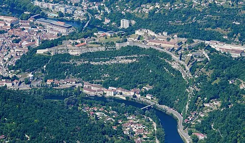
Citadel of Besançon Carsten Steger · CC BY-SA 4.0

Climate of Arrondissement of Besançon
Best months for sightseeingBest months for sightseeing: June–August.
This month · November
A wet month
Day 8° · Night 1° · Rain 108 mm
- Hottest month
- July (day 23°)
- Coldest month
- January (night -2°)
- Wettest month
- May (108 mm)
- Driest month
- March (80 mm)
Bars: average monthly low and high temperature. Below: precipitation. Monthly averages for 1970–2000 at about 18 km resolution, adjusted for elevation. Highlighted months are mild and relatively dry. Source: WorldClim 2.1 (CC BY 4.0).
Show values as a table
| Month | Jan | Feb | Mar | Apr | May | Jun | Jul | Aug | Sep | Oct | Nov | Dec |
|---|---|---|---|---|---|---|---|---|---|---|---|---|
| Average high (°C) | 4° | 6° | 10° | 13° | 18° | 21° | 23° | 23° | 19° | 14° | 8° | 5° |
| Average low (°C) | -2° | -1° | 1° | 3° | 8° | 11° | 13° | 12° | 9° | 6° | 1° | -1° |
| Precipitation (mm) | 92 | 89 | 80 | 93 | 108 | 104 | 87 | 81 | 103 | 106 | 108 | 105 |
How to get to Arrondissement of Besançon
The nearest airport is Dole Tavaux Airport (DLE), 54 km to the southwest as the crow flies. For international flights: Geneva International Airport (GVA) (110 km). The nearest large city is Besançon, 6 km to the west.
Airports
- Dole Tavaux Airport (DLE) Dole 54 kmsouthwest
- Geneva International Airport (GVA) Geneva 110 kmsouth
- Bern Airport (BRN) Bern 113 kmeast
Nearby large cities
- Besançon Population: 128.4K 6 kmwest
- Dijon Population: 159.9K 82 kmwest
- Lausanne Population: 139.1K 90 kmsoutheast
- Bern Population: 121.6K 108 kmeast
- Mulhouse Population: 111.4K 110 kmnortheast
Straight-line distances; road distances are longer. Airport data: OurAirports.
Day trips from Arrondissement of Besançon
Within 100 km: 178 historic and cultural sites, 539 natural sites, 211 lakes, rivers and coasts.
0–25 km54 places
- Mont des Buis Mountain 4 kmSW
- Forêt de Vaite Natural site 12 kmNE
- Bois d'Ully Natural site 19 kmS
- Bois sur Roche Natural site 17 kmSE
25–60 km182 places
- Lac des Taillères Lake 47 kmSE
- Lac de Moron Lake 52 kmE
- Lac des Brenets Lake 50 kmE
- Barrage de Biaufond Lake 58 kmE
60–100 km692 places
- Sankt Petersinsel Island 82 kmE
- Ile d'Ogoz Island 97 kmSE
- Lake Wohlen Lake 99 kmE
- Lake Neuchâtel Lake 69 kmSE
Straight-line distances.
Arrondissement of Besançon and similar cities
Side by side with cities of similar size in the same country: population, elevation and climate.
| Measure | Arrondissement of Besançon | Montpellier | Bordeaux | Lille |
|---|---|---|---|---|
| Population | 254.5K | 248.3K | 265.3K | 238.7K |
| Elevation | 457 m | 55 m | 20 m | 20 m |
| Summer day (hottest month) | 23° | 29° | 26° | 23° |
| Winter night (coldest month) | -2° | 3° | 2° | 1° |
| Annual rainfall | 1,156 mm | 645 mm | 921 mm | 716 mm |
| Best months | Jun–Aug | May–Oct | May–Sep | Jun–Aug |
| Distance | — | 438 km | 580 km | 439 km |
Climate values are 1970–2000 monthly averages; straight-line distance.
Places in Arrondissement of Besançon
252 places- 121 Jallerange 254
- 122 Champlive 253
- 123 Ougney-Douvot 249
- 124 Le Val 241
- 125 Grosbois 235
- 126 Lavans-Vuillafans 233
- 127 Passavant 230
- 128 Saules 225
- 129 Lods 221
- 130 Mésandans 219
- 131 Villers-Saint-Martin 216
- 132 Glamondans 214
- 133 Chay 213
- 134 Voillans 208
- 135 Dammartin-les-Templiers 206
- 136 Courchapon 205
- 137 Mazerolles-le-Salin 203
- 138 Servin 201
- 139 Lavans-Quingey 200
- 140 Corcelles-Ferrières 199
- 141 Braillans 198
- 142 Placey 198
- 143 Étrabonne 193
- 144 Val-de-Roulans 192
- 145 Cendrey 191
- 146 Lombard 190
- 147 Hyèvre-Paroisse 188
- 148 Myon 187
- 149 Pont-les-Moulins 187
- 150 Sauvagney 185
- 151 Malans 180
- 152 Durnes 177
- 153 Aïssey 175
- 154 Gondenans-Montby 175
- 155 Fourbanne 173
- 156 Longeville 171
- 157 Saint-Juan 171
- 158 Uzelle 171
- 159 Lanans 167
- 160 Lomont-sur-Crête 167
- 161 Avilley 166
- 162 Amathay-Vésigneux 163
- 163 Valleroy 163
- 164 Saint-Hilaire 162
- 165 Luxiol 161
- 166 Buffard 159
- 167 Flagey 159
- 168 Villers-Grélot 153
- 169 Malbrans 152
- 170 Nans-sous-Sainte-Anne 147
- 171 Mérey-Vieilley 145
- 172 Corcondray 144
- 173 La Chevillotte 143
- 174 Palise 141
- 175 Silley-Amancey 136
- 176 Tournans 132
- 177 Cubrial 131
- 178 Chevroz 130
- 179 Romain 130
- 180 Le Moutherot 129
Bar: population relative to the most populous place in this list.
Nearby attractions & nature
Everything nearby-
Bois d'Aglans Natural site, Doubs4.2 km S
-
Le Grand Bois Natural site, Doubs7.5 km S
-
Forêt de Chailluz Natural site, Doubs7.6 km N
-
Forêt de Chauley Natural site, Doubs8.6 km E
-
Forêt du Gros Bois Natural site, Doubs10 km SE
-
Les Corvées Natural site, Doubs12 km SW
-
Forêt de Vaite Natural site, Doubs12 km NE
-
Forêt de l'Aiguillon Natural site, Doubs18 km NE
Sources & licences
Data last updated: