Arrondissement of Besançon
Located in Doubs, Bourgogne-Franche-Comté Coordinates: 47°13′53″ N 6°05′11″ E
- Population
- 254,489
- 254.5K
- Elevation
- 457 m
- above sea level
- Local time
- UTC+01:00
- Europe/Paris · UTC+01:00
- Places inside
- 252
- listed under Arrondissement of Besançon
- Airports
- DLE Dole Tavaux Airport54 km
- GVA Geneva International Airport110 km
About Arrondissement of Besançon
Arrondissement of Besançon is a municipality. Location: Doubs, Bourgogne-Franche-Comté. Population: 254,489. Elevation: 457 m. The best months to visit are June–August. The nearest airport is Dole Tavaux Airport (54 km). Nearby sights include Bois d'Aglans and Le Grand Bois.
Photos of Arrondissement of Besançon
-
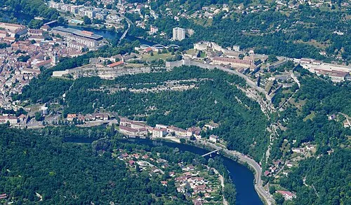
Citadel of Besançon Carsten Steger · CC BY-SA 4.0

Climate of Arrondissement of Besançon
Best months for sightseeingBest months for sightseeing: June–August.
This month · November
A wet month
Day 8° · Night 1° · Rain 108 mm
- Hottest month
- July (day 23°)
- Coldest month
- January (night -2°)
- Wettest month
- May (108 mm)
- Driest month
- March (80 mm)
Bars: average monthly low and high temperature. Below: precipitation. Monthly averages for 1970–2000 at about 18 km resolution, adjusted for elevation. Highlighted months are mild and relatively dry. Source: WorldClim 2.1 (CC BY 4.0).
Show values as a table
| Month | Jan | Feb | Mar | Apr | May | Jun | Jul | Aug | Sep | Oct | Nov | Dec |
|---|---|---|---|---|---|---|---|---|---|---|---|---|
| Average high (°C) | 4° | 6° | 10° | 13° | 18° | 21° | 23° | 23° | 19° | 14° | 8° | 5° |
| Average low (°C) | -2° | -1° | 1° | 3° | 8° | 11° | 13° | 12° | 9° | 6° | 1° | -1° |
| Precipitation (mm) | 92 | 89 | 80 | 93 | 108 | 104 | 87 | 81 | 103 | 106 | 108 | 105 |
How to get to Arrondissement of Besançon
The nearest airport is Dole Tavaux Airport (DLE), 54 km to the southwest as the crow flies. For international flights: Geneva International Airport (GVA) (110 km). The nearest large city is Besançon, 6 km to the west.
Airports
- Dole Tavaux Airport (DLE) Dole 54 kmsouthwest
- Geneva International Airport (GVA) Geneva 110 kmsouth
- Bern Airport (BRN) Bern 113 kmeast
Nearby large cities
- Besançon Population: 128.4K 6 kmwest
- Dijon Population: 159.9K 82 kmwest
- Lausanne Population: 139.1K 90 kmsoutheast
- Bern Population: 121.6K 108 kmeast
- Mulhouse Population: 111.4K 110 kmnortheast
Straight-line distances; road distances are longer. Airport data: OurAirports.
Day trips from Arrondissement of Besançon
Within 100 km: 178 historic and cultural sites, 539 natural sites, 211 lakes, rivers and coasts.
0–25 km54 places
- Mont des Buis Mountain 4 kmSW
- Forêt de Vaite Natural site 12 kmNE
- Bois d'Ully Natural site 19 kmS
- Bois sur Roche Natural site 17 kmSE
25–60 km182 places
- Lac des Taillères Lake 47 kmSE
- Lac de Moron Lake 52 kmE
- Lac des Brenets Lake 50 kmE
- Barrage de Biaufond Lake 58 kmE
60–100 km692 places
- Sankt Petersinsel Island 82 kmE
- Ile d'Ogoz Island 97 kmSE
- Lake Wohlen Lake 99 kmE
- Lake Neuchâtel Lake 69 kmSE
Straight-line distances.
Arrondissement of Besançon and similar cities
Side by side with cities of similar size in the same country: population, elevation and climate.
| Measure | Arrondissement of Besançon | Montpellier | Bordeaux | Lille |
|---|---|---|---|---|
| Population | 254.5K | 248.3K | 265.3K | 238.7K |
| Elevation | 457 m | 55 m | 20 m | 20 m |
| Summer day (hottest month) | 23° | 29° | 26° | 23° |
| Winter night (coldest month) | -2° | 3° | 2° | 1° |
| Annual rainfall | 1,156 mm | 645 mm | 921 mm | 716 mm |
| Best months | Jun–Aug | May–Oct | May–Sep | Jun–Aug |
| Distance | — | 438 km | 580 km | 439 km |
Climate values are 1970–2000 monthly averages; straight-line distance.
Places in Arrondissement of Besançon
252 places- 181 Montagney-Servigney 129
- 182 Thurey-le-Mont 129
- 183 Verne 129
- 184 Échay 128
- 185 Châtillon-Guyotte 127
- 186 Paroy 124
- 187 Crouzet-Migette 118
- 188 Gevresin 118
- 189 Séchin 118
- 190 Rignosot 117
- 191 Chassagne-Saint-Denis 116
- 192 Gouhelans 114
- 193 Bretigney-Notre-Dame 111
- 194 Le Puy 111
- 195 Flagey-Rigney 110
- 196 Vergranne 109
- 197 Corcelle-Mieslot 108
- 198 Courcelles 108
- 199 Guillon-les-Bains 104
- 200 Trouvans 104
- 201 Nans 102
- 202 Rennes-sur-Loue 99
- 203 Voires 97
- 204 Breconchaux 96
- 205 Mondon 95
- 206 Montmahoux 94
- 207 Rougemontot 94
- 208 Fontenelle-Montby 93
- 209 L'Écouvotte 93
- 210 Rillans 93
- 211 Viéthorey 93
- 212 Samson 92
- 213 Adam-lès-Passavant 91
- 214 Champoux 91
- 215 Vaudrivillers 90
- 216 Amondans 89
- 217 Échevannes 89
- 218 Ronchaux 88
- 219 Cubry 87
- 220 Lizine 87
- 221 Pessans 87
- 222 Huanne-Montmartin 82
- 223 Rouhe 82
- 224 Côtebrune 77
- 225 Goux-sous-Landet 77
- 226 Cademène 75
- 227 Gondenans-les-Moulins 75
- 228 Hyèvre-Magny 73
- 229 Mesmay 72
- 230 By 71
- 231 La Bretenière 71
- 232 Cusance 69
- 233 Palantine 67
- 234 Cussey-sur-Lison 66
- 235 Esnans 66
- 236 Fontenotte 62
- 237 Brères 60
- 238 Blarians 59
- 239 Germondans 59
- 240 Montussaint 59
Bar: population relative to the most populous place in this list.
Nearby attractions & nature
Everything nearby-
Bois d'Aglans Natural site, Doubs4.2 km S
-
Le Grand Bois Natural site, Doubs7.5 km S
-
Forêt de Chailluz Natural site, Doubs7.6 km N
-
Forêt de Chauley Natural site, Doubs8.6 km E
-
Forêt du Gros Bois Natural site, Doubs10 km SE
-
Les Corvées Natural site, Doubs12 km SW
-
Forêt de Vaite Natural site, Doubs12 km NE
-
Forêt de l'Aiguillon Natural site, Doubs18 km NE
Sources & licences
Data last updated: