Arrondissement of Mâcon
Located in Saône-et-Loire, Bourgogne-Franche-Comté Coordinates: 46°25′40″ N 4°39′47″ E
- Population
- 115,838
- 115.8K
- Elevation
- 237 m
- above sea level
- Local time
- UTC+01:00
- Europe/Paris · UTC+01:00
- Places inside
- 119
- listed under Arrondissement of Mâcon
- Airports
- LYS Lyon Saint-Exupéry Airport85 km
- DLE Dole Tavaux Airport90 km
About Arrondissement of Mâcon
Arrondissement of Mâcon is a municipality. Location: Saône-et-Loire, Bourgogne-Franche-Comté. Population: 115,838. Elevation: 237 m. The best months to visit are May–September. The nearest airport is Lyon Saint-Exupéry Airport (85 km). Nearby sights include Bois de Bourcier and Bois de Vaux.
Climate of Arrondissement of Mâcon
Best months for sightseeingBest months for sightseeing: May–September.
This month · November
A cold month
Day 10° · Night 3° · Rain 77 mm
- Hottest month
- July (day 26°)
- Coldest month
- January (night 0°)
- Wettest month
- June (85 mm)
- Driest month
- March (52 mm)
Bars: average monthly low and high temperature. Below: precipitation. Monthly averages for 1970–2000 at about 18 km resolution, adjusted for elevation. Highlighted months are mild and relatively dry. Source: WorldClim 2.1 (CC BY 4.0).
Show values as a table
| Month | Jan | Feb | Mar | Apr | May | Jun | Jul | Aug | Sep | Oct | Nov | Dec |
|---|---|---|---|---|---|---|---|---|---|---|---|---|
| Average high (°C) | 6° | 7° | 12° | 15° | 19° | 22° | 26° | 25° | 21° | 16° | 10° | 7° |
| Average low (°C) | 0° | 1° | 3° | 5° | 9° | 12° | 15° | 14° | 11° | 8° | 3° | 1° |
| Precipitation (mm) | 66 | 57 | 52 | 62 | 79 | 85 | 65 | 72 | 85 | 75 | 77 | 66 |
Other places to visit in this season: May June July August September
How to get to Arrondissement of Mâcon
The nearest airport is Lyon Saint-Exupéry Airport (LYS), 85 km to the southeast as the crow flies. The nearest large city is Villeurbanne, 75 km to the south.
Airports
- Lyon Saint-Exupéry Airport (LYS) Colombier-Saugnieu, Rhône 85 kmsoutheast
- Dole Tavaux Airport (DLE) Dole 90 kmnortheast
- Geneva International Airport (GVA) Geneva 113 kmeast
Nearby large cities
- Villeurbanne Population: 131.4K 75 kmsouth
- Lyon Population: 520.8K 77 kmsouth
- Dijon Population: 159.9K 102 kmnorth
- Saint-Etienne Population: 176.3K 112 kmsouth
- Geneva Population: 201.7K 117 kmeast
Straight-line distances; road distances are longer. Airport data: OurAirports.
Day trips from Arrondissement of Mâcon
Within 100 km: 162 historic and cultural sites, 399 natural sites, 244 lakes, rivers and coasts.
0–25 km50 places
- Bois Dieu Natural site 24 kmW
- Étang Neuf Lake 23 kmNW
- Grande Montagne Mountain 19 kmS
- Champvert Mountain 21 kmS
25–60 km165 places
- Étang des Vavres Lake 52 kmSE
- Étang de Torcy-Neuf Lake 42 kmNW
- Étang de la Noue Lake 53 kmN
- Étang Moulin Lake 46 kmSE
60–100 km590 places
- Parc de la Tête d'Or Natural site 74 kmS
- Étang de la Toison Lake 61 kmNW
- Étang de Tabouret Lake 88 kmSE
- Lake Sylans Lake 83 kmE
Straight-line distances.
Arrondissement of Mâcon and similar cities
Side by side with cities of similar size in the same country: population, elevation and climate.
| Measure | Arrondissement of Mâcon | Rouen | Orléans | Mulhouse |
|---|---|---|---|---|
| Population | 115.8K | 116.3K | 116.3K | 111.4K |
| Elevation | 237 m | 21 m | 115 m | 238 m |
| Summer day (hottest month) | 26° | 23° | 25° | 25° |
| Winter night (coldest month) | 0° | 2° | 1° | -1° |
| Annual rainfall | 841 mm | 724 mm | 641 mm | 725 mm |
| Best months | May–Sep | Jun–Aug | Jun–Sep | May–Sep |
| Distance | — | 428 km | 266 km | 250 km |
Climate values are 1970–2000 monthly averages; straight-line distance.
Places in Arrondissement of Mâcon
119 places- 61 Montmelard 349
- 62 Milly-Lamartine 343
- 63 Bonnay-Saint-Ythaire 333
- 64 Charbonnières 332
- 65 Lournand 332
- 66 Bourgvilain 326
- 67 Pruzilly 326
- 68 Saint-Point 319
- 69 Sainte-Cécile 291
- 70 Le Villars 287
- 71 Serrières 278
- 72 Buffières 276
- 73 Trivy 274
- 74 Cruzille 261
- 75 Saint-Léger-sous-la-Bussière 261
- 76 Vergisson 254
- 77 Cortevaix 252
- 78 Saint-André-le-Désert 251
- 79 Chissey-lès-Mâcon 240
- 80 Cortambert 234
- 81 Château 225
- 82 Ozenay 225
- 83 La Truchère 223
- 84 Farges-lès-Mâcon 216
- 85 Bergesserin 205
- 86 Bissy-la-Mâconnaise 205
- 87 Chardonnay 199
- 88 La Chapelle-du-Mont-de-France 187
- 89 Saint-Marcelin-de-Cray 184
- 90 Chasselas 175
- 91 Ameugny 170
- 92 Taizé 170
- 93 Blanot 169
- 94 Flagy 167
- 95 Saint-Vérand 167
- 96 Sivignon 167
- 97 Donzy-le-Pertuis 166
- 98 Martailly-lès-Brancion 142
- 99 Royer 132
- 100 Saint-Clément-sur-Guye 131
- 101 La Chapelle-sous-Brancion 130
- 102 Bray 127
- 103 Germolles-sur-Grosne 127
- 104 Burgy 119
- 105 Saint-Vincent-des-Prés 110
- 106 Saint-Martin-de-Salencey 101
- 107 Sigy-le-Châtel 100
- 108 Pressy-sous-Dondin 97
- 109 Chiddes 95
- 110 Sailly 90
- 111 Curtil-sous-Buffières 88
- 112 Chevagny-sur-Guye 74
- 113 Burzy 64
- 114 Passy 63
- 115 Saint-Martin-la-Patrouille 63
- 116 Berzé-le-Châtel 59
- 117 Saint-Huruge 54
- 118 Grevilly 36
- 119 Chérizet 21
Bar: population relative to the most populous place in this list.
Nearby attractions & nature
Everything nearby-
Bois de Bourcier Natural site, Saône-et-Loire2.2 km E
-
Bois de Vaux Natural site, Saône-et-Loire3.8 km SE
-
Ruisseau Valouse River, Saône-et-Loire5 km S
-
Forêt de Gousseau Natural site, Saône-et-Loire8.9 km N
-
Bois de Verzé Natural site, Saône-et-Loire9.8 km SE
-
Bois de Mont-Saint-Romain Natural site, Saône-et-Loire11 km NE
-
Monts du Mâconnais Mountain, Saône-et-Loire16 km SE
-
Ruisseau Talenchant River, Saône-et-Loire11 km SE
Other cities and towns in Saône-et-Loire
-
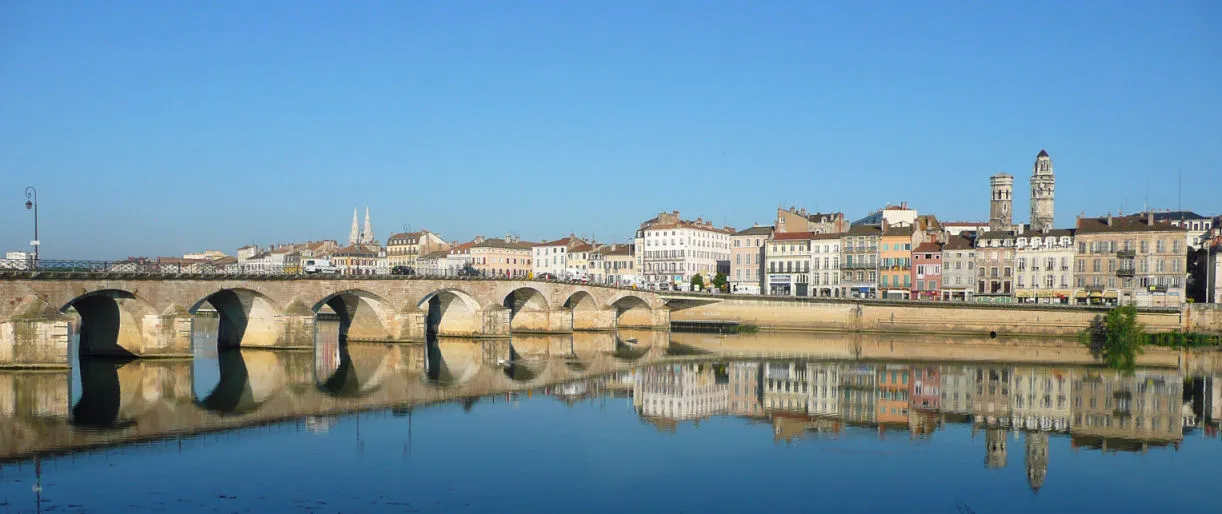 Mâcon City, Mâcon18 km SE
-
Arrondissement of Chalon-sur-Saône Municipality, Saône-et-Loire42 km N
-
Charnay-lès-Mâcon Town, Charnay-lès-Mâcon16 km SE
-
Arrondissement of Charolles Municipality, Saône-et-Loire44 km W
-
Arrondissement of Autun Municipality, Saône-et-Loire56 km NW
-
Arrondissement of Louhans Municipality, Saône-et-Loire51 km NE
Sources & licences
Data last updated: