- Population
- 144,899
- 144.9K
- Elevation
- 49 m
- above sea level
- Local time
- UTC+01:00
- Europe/Paris · UTC+01:00
- Airports
- BES Brest Bretagne airport8 km
- GCI Guernsey Airport180 km
About Brest
Brest is a city. Location: Brest, Arrondissement de Brest. Population: 144,899. Elevation: 49 m. The best months to visit are June–September. The nearest airport is Brest Bretagne airport (8 km). Nearby sights include Église Saint-Louis and Artothèque de Brest.
Photos of Brest
-
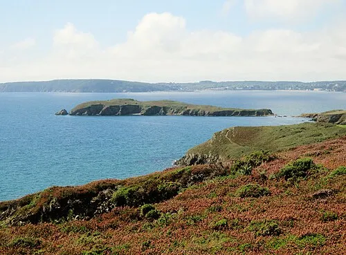
Île de l'Aber Moreau.henri · CC BY-SA 4.0 -
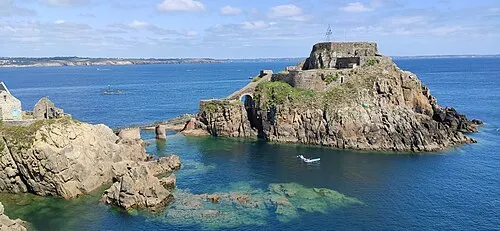
Fort de Bertheaume Thesupermat · CC BY-SA 4.0 -
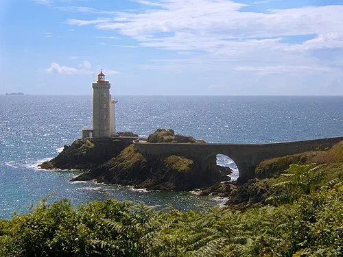
Phare du Petit Minou Rundvald · Public domain


Climate of Brest
Best months for sightseeingBest months for sightseeing: June–September.
This month · November
A wet month
Day 12° · Night 7° · Rain 122 mm
- Hottest month
- August (day 20°)
- Coldest month
- February (night 4°)
- Wettest month
- December (136 mm)
- Driest month
- July (48 mm)
Bars: average monthly low and high temperature. Below: precipitation. Monthly averages for 1970–2000 at about 18 km resolution, adjusted for elevation. Highlighted months are mild and relatively dry. Source: WorldClim 2.1 (CC BY 4.0).
Show values as a table
| Month | Jan | Feb | Mar | Apr | May | Jun | Jul | Aug | Sep | Oct | Nov | Dec |
|---|---|---|---|---|---|---|---|---|---|---|---|---|
| Average high (°C) | 9° | 10° | 11° | 13° | 16° | 18° | 20° | 20° | 19° | 15° | 12° | 10° |
| Average low (°C) | 5° | 4° | 5° | 6° | 9° | 11° | 13° | 13° | 12° | 10° | 7° | 6° |
| Precipitation (mm) | 135 | 113 | 95 | 77 | 70 | 55 | 48 | 59 | 87 | 111 | 122 | 136 |
Other places to visit in this season: June July August September
How to get to Brest
The nearest airport is Brest Bretagne airport (BES), 8 km to the northeast as the crow flies. The nearest large city is Rennes, 211 km to the east.
Airports
- Brest Bretagne airport (BES) Brest 8 kmnortheast
- Guernsey Airport (GCI) Saint Peter Port 180 kmnortheast
- Jersey Airport (JER) St. Peter 191 kmnortheast
Nearby large cities
- Rennes Population: 227.8K 211 kmeast
- Plymouth Population: 260.2K 222 kmnorth
- Nantes Population: 325.1K 255 kmsoutheast
- Exeter Population: 130.7K 269 kmnorth
- Angers Population: 168.3K 311 kmeast
Straight-line distances; road distances are longer. Airport data: OurAirports.
Day trips from Brest
Within 100 km: 203 historic and cultural sites, 109 natural sites, 188 lakes, rivers and coasts.
0–25 km138 places
- Plage du Trez-Hir Beach 17 kmW
- Plage de Bertheaume Beach 17 kmW
- Plage des trois curés Beach 17 kmW
- Plage de Sainte Anne Beach 16 kmW
25–60 km180 places
- Île de Quéménès Island 31 kmW
- Plage de Kermabec Beach 57 kmS
- Plage de Penhors Beach 51 kmS
- Plage de Guendrez Beach 44 kmS
60–100 km182 places
- Île Grande Island 81 kmNE
- Kastell Koad Freg Historic site 86 kmNE
- Kastell Tonkedeg Historic site 85 kmE
- Île aux Rats Island 64 kmS
Straight-line distances.
Brest and similar cities
Side by side with cities of similar size in the same country: population, elevation and climate.
| Measure | Brest | Le Mans | Saint-Quentin-en-Yvelines | Amiens |
|---|---|---|---|---|
| Population | 144.9K | 144.5K | 146.6K | 143.1K |
| Elevation | 49 m | 65 m | 166 m | 28 m |
| Summer day (hottest month) | 20° | 25° | 24° | 23° |
| Winter night (coldest month) | 4° | 2° | 1° | 1° |
| Annual rainfall | 1,108 mm | 673 mm | 646 mm | 680 mm |
| Best months | Jun–Sep | Jun–Sep | Jun–Sep | Jun–Aug |
| Distance | — | 351 km | 482 km | 523 km |
Climate values are 1970–2000 monthly averages; straight-line distance.
Nearby attractions & nature
Everything nearby-
Église Saint-Louis Attraction, Brest0.3 km SW
-
Artothèque de Brest Museum, Brest0.7 km SW
-
Pont Robert-Schuman Landmark, Brest0.9 km N
-
Ancien Pont National Landmark, Brest1 km SW
-
Tour Tanguy Historic site, Brest1.1 km SW
-
Jardin des Explorateurs Natural site, Brest1.4 km SW
-
le Château de Brest Historic site, Brest1.2 km SW
-
Jardin de Kerbonne Natural site, Brest2.5 km SW
Sources & licences
Data last updated: