- Elevation
- 1 m
- above sea level
- Local time
- UTC+01:00
- Europe/Paris · UTC+01:00
- Airports
- BES Brest Bretagne airport113 km
- RNS Rennes-Saint-Jacques Airport129 km
About Plage de Toulhars
Plage de Toulhars is a beach. Location: Morbihan, Brittany Region. The best months to visit are June–September. The nearest airport is Brest Bretagne airport (113 km). Nearby sights include Plage de Larmor and Étang du Ter.
Photos of Plage de Toulhars
-
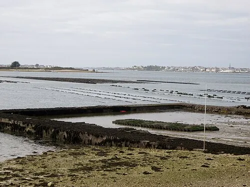
Île de Kerner Moreau.henri · CC BY-SA 4.0

Climate of Plage de Toulhars
Best months for sightseeingBest months for sightseeing: June–September.
This month · November
A wet month
Day 13° · Night 7° · Rain 120 mm
- Hottest month
- August (day 23°)
- Coldest month
- February (night 4°)
- Wettest month
- November (120 mm)
- Driest month
- July (42 mm)
Bars: average monthly low and high temperature. Below: precipitation. Monthly averages for 1970–2000 at about 18 km resolution, adjusted for elevation. Highlighted months are mild and relatively dry. Source: WorldClim 2.1 (CC BY 4.0).
Show values as a table
| Month | Jan | Feb | Mar | Apr | May | Jun | Jul | Aug | Sep | Oct | Nov | Dec |
|---|---|---|---|---|---|---|---|---|---|---|---|---|
| Average high (°C) | 10° | 10° | 12° | 14° | 18° | 20° | 23° | 23° | 20° | 17° | 13° | 11° |
| Average low (°C) | 4° | 4° | 6° | 7° | 10° | 12° | 14° | 14° | 12° | 10° | 7° | 5° |
| Precipitation (mm) | 112 | 88 | 76 | 62 | 66 | 49 | 42 | 52 | 72 | 89 | 120 | 111 |
Other places to visit in this season: June July August September
How to get to Plage de Toulhars
The nearest airport is Brest Bretagne airport (BES), 113 km to the northwest as the crow flies. The nearest large city is Brest, 112 km to the northwest.
Airports
- Brest Bretagne airport (BES) Brest 113 kmnorthwest
- Rennes-Saint-Jacques Airport (RNS) Saint-Jacques-de-la-Lande, Ille-et-Vilaine 129 kmeast
- Nantes Atlantique Airport (NTE) Nantes 147 kmsoutheast
Nearby large cities
- Brest Population: 144.9K 112 kmnorthwest
- Rennes Population: 227.8K 135 kmeast
- Nantes Population: 325.1K 148 kmeast
- Angers Population: 168.3K 214 kmeast
- Le Mans Population: 144.5K 270 kmeast
Straight-line distances; road distances are longer. Airport data: OurAirports.
Day trips from Plage de Toulhars
Within 100 km: 199 historic and cultural sites, 148 natural sites, 244 lakes, rivers and coasts.
0–25 km65 places
- Île de Groix Island 10 kmSW
- Plage de Kerguélen Beach 2 kmW
- Plage de Larmor Beach 1 kmSW
- Plage de Sables Blancs Beach 25 kmSE
25–60 km290 places
- Belle Île Island 44 kmS
- Plage de Carnac Beach 28 kmSE
- Moros River 44 kmNW
- Plage Beg Lann Beach 53 kmSE
60–100 km236 places
- Île aux Rats Island 63 kmW
- Plage de la Courance Beach 98 kmSE
- Plage Sainte-Marguerite Beach 96 kmSE
- Plage de la Baule Beach 91 kmSE
Straight-line distances.
Nearest towns and villages
-
Larmor-Plage Village, Arrondissement of Lorient0.4 km W
-
Larmor-Plage Town, Larmor-Plage0.4 km W
-
Port-Louis Village, Arrondissement of Lorient1.9 km E
-
Port-Louis Village, Port-Louis1.9 km E
-
Gâvres Village, Arrondissement of Lorient2.4 km SE
-
Gâvres Village, Gâvres2.3 km SE
Nearby attractions & nature
Everything nearby-
Plage de Larmor Beach, Morbihan0.4 km SW
-
Étang du Ter Lake, Morbihan1.1 km N
-
Île aux Souris Island, Brittany Region1.7 km E
-
Plage de Kerguélen Beach, Larmor-Plage1.9 km W
-
Anse de Kerguélen Natural site, Morbihan2.4 km W
-
Île Saint-Michel Island, Morbihan2.6 km NE
-
Fort de Locqueltas Historic site, Larmor-Plage0.8 km SW
-
Citadelle de Port-Louis Historic site, Port-Louis1.2 km E
More lakes, rivers and coasts in France
-
Île de Kerner Island, Morbihan5 km E
-
Île de Groix Island, Morbihan10 km SW
-
Blavet River, Morbihan4.3 km NE
-
Plage les Grands Sables Beach, Groix8.3 km SW
-
Ter River, Morbihan3 km N
-
Scorff River, Morbihan4.5 km NE
Sources & licences
Data last updated: