Bois de Chançay
Located in Indre-et-Loire, Centre-Val de Loire Coordinates: 47°26′47″ N 0°54′35″ E
- Elevation
- 116 m
- above sea level
- Local time
- UTC+01:00
- Europe/Paris · UTC+01:00
- Airports
- TUF Tours Val de Loire Airport14 km
- PIS Poitiers-Biard Airport106 km
About Bois de Chançay
Bois de Chançay is a natural site. Location: Indre-et-Loire, Centre-Val de Loire. The best months to visit are June–September. The nearest airport is Tours Val de Loire Airport (14 km). Nearby sights include Clos Lucé and Forêt d'Amboise.
Photos of Bois de Chançay
-
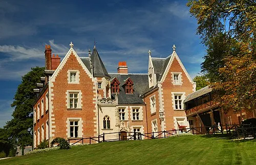
Clos Lucé Nadègevillain · CC BY-SA 3.0

Climate of Bois de Chançay
Best months for sightseeingBest months for sightseeing: June–September.
This month · November
A cold month
Day 11° · Night 4° · Rain 68 mm
- Hottest month
- July (day 25°)
- Coldest month
- January (night 1°)
- Wettest month
- November (68 mm)
- Driest month
- August (43 mm)
Bars: average monthly low and high temperature. Below: precipitation. Monthly averages for 1970–2000 at about 18 km resolution, adjusted for elevation. Highlighted months are mild and relatively dry. Source: WorldClim 2.1 (CC BY 4.0).
Show values as a table
| Month | Jan | Feb | Mar | Apr | May | Jun | Jul | Aug | Sep | Oct | Nov | Dec |
|---|---|---|---|---|---|---|---|---|---|---|---|---|
| Average high (°C) | 7° | 8° | 12° | 15° | 19° | 22° | 25° | 25° | 21° | 16° | 11° | 8° |
| Average low (°C) | 1° | 1° | 3° | 5° | 9° | 11° | 13° | 13° | 10° | 7° | 4° | 2° |
| Precipitation (mm) | 62 | 60 | 50 | 53 | 62 | 48 | 48 | 43 | 56 | 59 | 68 | 65 |
Other places to visit in this season: June July August September
How to get to Bois de Chançay
The nearest airport is Tours Val de Loire Airport (TUF), 14 km to the west as the crow flies. The nearest large city is Tours, 17 km to the west.
Airports
- Tours Val de Loire Airport (TUF) Tours, Indre-et-Loire 14 kmwest
- Poitiers-Biard Airport (PIS) Poitiers/Biard 106 kmsouthwest
- Limoges Airport (LIG) Limoges/Bellegarde 177 kmsouth
Nearby large cities
- Tours Population: 141.6K 17 kmwest
- Le Mans Population: 144.5K 81 kmnorthwest
- Orléans Population: 116.3K 90 kmnortheast
- Angers Population: 168.3K 110 kmwest
- Saint-Quentin-en-Yvelines Population: 146.6K 169 kmnortheast
Straight-line distances; road distances are longer. Airport data: OurAirports.
Day trips from Bois de Chançay
Within 100 km: 194 historic and cultural sites, 177 natural sites, 239 lakes, rivers and coasts.
0–25 km61 places
- Lac de la Bergeonnerie Lake 19 kmSW
- Bois de Sudaie Natural site 23 kmE
- Bois de Saint-Laurent Natural site 22 kmSW
- Bois de Nouzilly Natural site 18 kmNW
25–60 km184 places
- Étang de Vilpale Lake 55 kmE
- Étang du Val Joyeux Lake 45 kmW
- Étang Perret Lake 47 kmE
- Étang Bouchard Lake 42 kmW
60–100 km365 places
- Neuve River 90 kmE
- Dive River 96 kmNW
- Cloche River 99 kmN
- Ile au Than Beach Beach 69 kmW
Straight-line distances.
Nearest towns and villages
-
Chançay Village, Arrondissement of Tours2.9 km W
-
Nazelles-Négron Village, Arrondissement of Loches3.7 km SE
-
Noizay Village, Arrondissement of Loches3.1 km SW
-
Chançay Village, Chançay2.8 km W
-
Nazelles-Négron Village, Nazelles-Négron3.4 km SE
-
Noizay Village, Noizay3 km SW
Nearby attractions & nature
Everything nearby-
Clos Lucé Historic site, Amboise7.4 km SE
-
Forêt d'Amboise Natural site, Indre-et-Loire11 km SE
-
Brenne River, Indre-et-Loire6.6 km SW
-
Masse River, Indre-et-Loire6.7 km SE
-
Église Saint-Symphorien de Négron Attraction, Nazelles-Négron5.1 km SE
-
Bois de Chaume Natural site, Indre-et-Loire11 km E
-
Bois de Mortier Natural site, Indre-et-Loire15 km NW
-
Bois de la Couarde Natural site, Indre-et-Loire15 km N
Sources & licences
Data last updated: