Arrondissement of Nancy
Located in Meurthe et Moselle, Grand Est Coordinates: 48°41′56″ N 6°12′03″ E
- Population
- 428,111
- 428.1K
- Elevation
- 196 m
- above sea level
- Local time
- UTC+01:00
- Europe/Paris · UTC+01:00
- Places inside
- 196
- listed under Arrondissement of Nancy
- Airports
- ETZ Metz-Nancy-Lorraine Airport32 km
- SCN Saarbrücken Airport88 km
About Arrondissement of Nancy
Arrondissement of Nancy is a municipality. Location: Meurthe et Moselle, Grand Est. Population: 428,111. Elevation: 196 m. The best months to visit are June–September. The nearest airport is Metz-Nancy-Lorraine Airport (32 km). Nearby sights include Palais Ducal and Plateau de Malzéville.
Photos of Arrondissement of Nancy
-
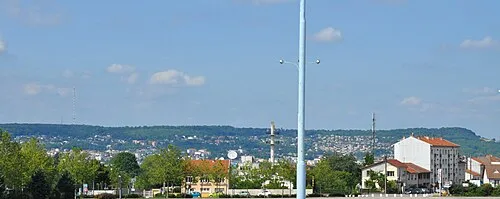
Plateau de Malzéville Speculos · CC BY-SA 3.0

Climate of Arrondissement of Nancy
Best months for sightseeingBest months for sightseeing: June–September.
This month · November
A cold month
Day 8° · Night 2° · Rain 70 mm
- Hottest month
- July (day 24°)
- Coldest month
- January (night -1°)
- Wettest month
- December (80 mm)
- Driest month
- April (51 mm)
Bars: average monthly low and high temperature. Below: precipitation. Monthly averages for 1970–2000 at about 18 km resolution, adjusted for elevation. Highlighted months are mild and relatively dry. Source: WorldClim 2.1 (CC BY 4.0).
Show values as a table
| Month | Jan | Feb | Mar | Apr | May | Jun | Jul | Aug | Sep | Oct | Nov | Dec |
|---|---|---|---|---|---|---|---|---|---|---|---|---|
| Average high (°C) | 5° | 6° | 10° | 14° | 19° | 22° | 24° | 24° | 20° | 14° | 8° | 6° |
| Average low (°C) | -1° | -1° | 2° | 4° | 8° | 11° | 13° | 13° | 10° | 6° | 2° | 1° |
| Precipitation (mm) | 65 | 63 | 59 | 51 | 70 | 75 | 65 | 59 | 64 | 68 | 70 | 80 |
Other places to visit in this season: June July August September
How to get to Arrondissement of Nancy
The nearest airport is Metz-Nancy-Lorraine Airport (ETZ), 32 km to the north as the crow flies. For international flights: Luxembourg-Findel International Airport (LUX) (103 km). The nearest large city is Nancy, 2 km to the southwest.
Airports
- Metz-Nancy-Lorraine Airport (ETZ) Goin 32 kmnorth
- Saarbrücken Airport (SCN) Saarbrücken 88 kmnortheast
- Luxembourg-Findel International Airport (LUX) Luxembourg 103 kmnorth
Nearby large cities
- Nancy Population: 105.1K 2 kmsouthwest
- Metz Population: 123.9K 47 kmnorth
- Saarbrücken Population: 183K 84 kmnortheast
- Strasbourg Population: 274.8K 115 kmeast
- Trier Population: 100.1K 122 kmnorth
Straight-line distances; road distances are longer. Airport data: OurAirports.
Day trips from Arrondissement of Nancy
Within 100 km: 225 historic and cultural sites, 873 natural sites, 197 lakes, rivers and coasts.
0–25 km56 places
- Butte de Mousson Mountain 25 kmN
- Mont Saint-Michel Mountain 24 kmW
- Forêt de Vitrimont Natural site 21 kmSE
- Forêt Domaniale de Puvenelle Natural site 24 kmNW
25–60 km186 places
- Étang de Vargévaux Lake 40 kmNW
- Étang du Stock Lake 54 kmE
- Étang Romé Lake 31 kmW
- Étang de la Perche Lake 43 kmNW
60–100 km1,053 places
- Jungen Busch Natural site 99 kmN
- Bois Haut Natural site 100 kmN
- Bois de Frihaut Natural site 99 kmN
- Tëtelbierg Mountain 97 kmN
Straight-line distances.
Arrondissement of Nancy and similar cities
Side by side with cities of similar size in the same country: population, elevation and climate.
| Measure | Arrondissement of Nancy | Toulouse | Lyon | Nice |
|---|---|---|---|---|
| Population | 428.1K | 511.7K | 520.8K | 342.7K |
| Elevation | 196 m | 150 m | 173 m | 25 m |
| Summer day (hottest month) | 24° | 28° | 27° | 28° |
| Winter night (coldest month) | -1° | 2° | 1° | 5° |
| Annual rainfall | 789 mm | 683 mm | 844 mm | 807 mm |
| Best months | Jun–Sep | May–Oct | May–Sep | May–Sep |
| Distance | — | 675 km | 344 km | 561 km |
Climate values are 1970–2000 monthly averages; straight-line distance.
Places in Arrondissement of Nancy
196 places- 1 Nancy 104.6K
- 2 Vandœuvre-lès-Nancy 30.2K
- 3 Villers-lès-Nancy 14.5K
- 4 Pont-à-Mousson 14.4K
- 5 Laxou 14.3K
- 6 Maxéville 9.9K
- 7 Saint-Max 9.9K
- 8 Dombasle-sur-Meurthe 9.8K
- 9 Jarville-la-Malgrange 9.2K
- 10 Tomblaine 8.9K
- 11 Essey-lès-Nancy 8.7K
- 12 Malzéville 8K
- 13 Saint-Nicolas-de-Port 7.6K
- 14 Neuves-Maisons 6.8K
- 15 Champigneulles 6.8K
- 16 Frouard 6.6K
- 17 Laneuveville-devant-Nancy 6.5K
- 18 Ludres 6.3K
- 19 Liverdun 6K
- 20 Heillecourt 5.6K
- 21 Pompey 4.9K
- 22 Seichamps 4.9K
- 23 Dieulouard 4.8K
- 24 Pulnoy 4.7K
- 25 Blénod-lès-Pont-à-Mousson 4.6K
- 26 Bouxières-aux-Dames 4.2K
- 27 Pagny-sur-Moselle 4.2K
- 28 Saulxures-lès-Nancy 4.1K
- 29 Varangéville 3.7K
- 30 Custines 3K
- 31 Chaligny 2.9K
- 32 Rosières-aux-Salines 2.9K
- 33 Lay-Saint-Christophe 2.5K
- 34 Richardménil 2.4K
- 35 Fléville-devant-Nancy 2.3K
- 36 Houdemont 2.1K
- 37 Pont-Saint-Vincent 1.9K
- 38 Chavigny 1.9K
- 39 Messein 1.9K
- 40 Flavigny-sur-Moselle 1.7K
- 41 Marbache 1.7K
- 42 Maidières 1.5K
- 43 Saizerais 1.5K
- 44 Vézelise 1.4K
- 45 Belleville 1.4K
- 46 Bouxières-aux-Chênes 1.4K
- 47 Art-sur-Meurthe 1.4K
- 48 Bainville-sur-Madon 1.4K
- 49 Méréville 1.4K
- 50 Champenoux 1.4K
- 51 Faulx 1.3K
- 52 Norroy-lès-Pont-à-Mousson 1.2K
- 53 Nomeny 1.2K
- 54 Pulligny 1.2K
- 55 Montauville 1.1K
- 56 Eulmont 1K
- 57 Sommerviller 986
- 58 Malleloy 981
- 59 Maizières 980
- 60 Jezainville 949
Bar: population relative to the most populous place in this list.
Nearby attractions & nature
Everything nearby-
Palais Ducal Historic site, Meurthe et Moselle1.6 km W
-
Plateau de Malzéville Natural site, Meurthe et Moselle3.3 km N
-
Bois de Faulx Natural site, Meurthe et Moselle8.6 km N
-
Forêt Domaniale de Haye Natural site, Meurthe et Moselle8.8 km W
-
Meurthe River, Meurthe et Moselle10 km NW
-
Forêt Domaniale de l'Avant-Garde Natural site, Meurthe et Moselle11 km NW
-
Mauchère River, Meurthe et Moselle11 km NW
-
Cité d'Affrique Historic site, Grand Est9.7 km SW
Sources & licences
Data last updated: