
- Population
- 416,325
- 416.3K
- Elevation
- 180 m
- above sea level
- Local time
- UTC+01:00
- Europe/Paris · UTC+01:00
- Places inside
- 69
- listed under Dordogne
- Airports
- EGC Bergerac Dordogne-Périgord airport38 km
- BVE Brive Souillac airport60 km
About Dordogne
Dordogne is a district. Location: New Aquitaine, France. Population: 416,325.
Dordogne (UK: dor-DOYN, US: dor-DOHN or dor-DAWN-yə; French: [dɔʁdɔɲ] ; Occitan: Dordonha [duɾˈduɲɔ]) is a large rural department in southwest France, with its prefecture in Périgueux. Located in the Nouvelle-Aquitaine region roughly half-way between the Loire Valley and the Pyrenees, it is named after the river Dordogne, which runs through it. It corresponds roughly to the ancient county of Périgord. In January 2023, Dordogne had a population of 417,614.
Source: Wikipedia · CC BY-SA 4.0
Photos of Dordogne
-
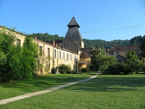
Cadouin Abbey Benjamin Lefèvre · CC BY-SA 3.0 -
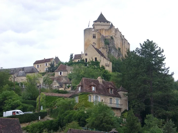
Château de Castelnaud-la-Chapelle Wikimedia Commons · CC BY-SA 3.0


Travel notes for Dordogne
From Wikivoyage
The Dordogne is a region of Nouvelle-Aquitaine, France. Dordogne is one of France's best-loved areas.
Castles, châteaux, and other important historical museums are sprinkled throughout the region, offering enough historical interest for any aficionado, but attractively distributed throughout a breathtaking scenery that needs no scholarly tendencies to enjoy it.
While long a favourite with visitors, the region has escaped much of the overdevelopment of some of France's other regions.
Understand+
The Dordogne department roughly follows the shape of the historic Périgord, a former province and one of the primary battlegrounds during the Hundred Years' War. The name is still commonly used by the French, as the Dordogne is divided into four regions, named after the historic province. They're the Périgord Vert (Green, in the north), the Périgord Blanc (White, in the north-east), Périgord Noir (Black, in the south-east) and the Périgord Pourpre (Purple, in the south-west).
Get in+
By car to the Dordogne, the A20 and then the A89 to Périgueux.
Source: Wikivoyage · CC BY-SA 4.0 · abridged
Places bordering Dordogne
- Charente
- Charente-Maritime
- Corrèze department
- Gironde
- Lot-et-Garonne
- Haute-Vienne
Population of Dordogne over time
| 2015 | 415,417 | |
|---|---|---|
| 2017 | 413,606 | |
| 2018 | 413,418 | |
| 2019 | 413,223 | |
| 2020 | 412,807 | |
| 2021 | 413,730 | |
| 2022 | 416,325 | |
| 2023 | 417,614 |
Censuses and official estimates; source: Wikidata.
Climate of Dordogne
Best months for sightseeingBest months for sightseeing: June–September.
This month · November
A wet month
Day 12° · Night 5° · Rain 103 mm
- Hottest month
- August (day 26°)
- Coldest month
- January (night 2°)
- Wettest month
- November (103 mm)
- Driest month
- July (56 mm)
Bars: average monthly low and high temperature. Below: precipitation. Monthly averages for 1970–2000 at about 18 km resolution, adjusted for elevation. Highlighted months are mild and relatively dry. Source: WorldClim 2.1 (CC BY 4.0).
Show values as a table
| Month | Jan | Feb | Mar | Apr | May | Jun | Jul | Aug | Sep | Oct | Nov | Dec |
|---|---|---|---|---|---|---|---|---|---|---|---|---|
| Average high (°C) | 9° | 11° | 14° | 16° | 20° | 23° | 26° | 26° | 23° | 18° | 12° | 10° |
| Average low (°C) | 2° | 3° | 4° | 6° | 10° | 12° | 14° | 14° | 12° | 9° | 5° | 3° |
| Precipitation (mm) | 92 | 86 | 70 | 82 | 87 | 68 | 56 | 62 | 85 | 93 | 103 | 102 |
Other places to visit in this season: June July August September
How to get to Dordogne
The nearest airport is Bergerac Dordogne-Périgord airport (EGC), 38 km to the southwest as the crow flies. The nearest large city is Limoges, 88 km to the northeast.
Airports
- Bergerac Dordogne-Périgord airport (EGC) Bergerac 38 kmsouthwest
- Brive Souillac airport (BVE) Brive 60 kmeast
- Limoges Airport (LIG) Limoges/Bellegarde 89 kmnortheast
Nearby large cities
- Limoges Population: 141.2K 88 kmnortheast
- Bordeaux Population: 265.3K 109 kmwest
- Toulouse Population: 511.7K 178 kmsouth
- Clermont-Ferrand Population: 147.9K 198 kmeast
- Tours Population: 141.6K 252 kmnorth
Straight-line distances; road distances are longer. Airport data: OurAirports.
Day trips from Dordogne
Within 100 km: 76 historic and cultural sites, 69 natural sites, 194 lakes, rivers and coasts.
0–25 km21 places
- Forêt de Monclard Natural site 25 kmSW
- Forêt de Lammary Natural site 15 kmNE
- Forêt de Feytaud Natural site 14 kmNW
- Parc de Fayolle Natural site 21 kmNW
25–60 km90 places
- Grand Étang de la Gourgousse Lake 49 kmN
- Puy d'Yssandon Mountain 51 kmE
- Forêt de Vieillecour Natural site 55 kmNE
- La Forêt Vieille Natural site 50 kmNE
60–100 km228 places
- Étang de Taysse Lake 94 kmE
- Étang de Ruffaud Lake 91 kmE
- Étang du Prévôt Lake 99 kmE
- Étang de Pissevache Lake 81 kmE
Straight-line distances.
Places in Dordogne
69 placesMountains & nature1
- Vallée de la Dordogne · Natural site
Lakes, rivers & coasts8
- Ruisseau le Tord · River
- Ruisseau l'Eyraud · River
- Russeau de Vitrac · River
- Souvanie · River
- Taloux · River
- Trieux · River
- Vergt · River
- Vézère · River
Nature and heritage in Dordogne
Other regions in New Aquitaine
-
 Haute-Vienne District, New Aquitaine92 km NE
-
 Corrèze department District, New Aquitaine93 km E
-
 Charente District, New Aquitaine78 km NW
-
 Gironde District, New Aquitaine103 km SW
-
 Lot-et-Garonne District, New Aquitaine90 km S
-
 Charente-Maritime District, New Aquitaine133 km NW
Sources & licences
Data last updated: · 2 independent sources