- Population
- 332,226
- 332.2K
- Elevation
- 143 m
- above sea level
- Local time
- UTC+01:00
- Europe/Paris · UTC+01:00
- Places inside
- 50
- listed under Lot-et-Garonne
- Airports
- EGC Bergerac Dordogne-Périgord airport55 km
- TLS Toulouse-Blagnac Airport105 km
About Lot-et-Garonne
Lot-et-Garonne is a district. Location: New Aquitaine, France. Population: 332,226.
Lot-et-Garonne (French pronunciation: [lɔt e ɡaʁɔn] , Occitan: Òlt e Garona; lit. 'Lot and Garonne') is a department in the Nouvelle-Aquitaine region of Southwestern France. Named after the rivers Lot and Garonne, it had a population of 333,602 in 2023. Its prefecture and largest city is Agen.
Source: Wikipedia · CC BY-SA 4.0
Photos of Lot-et-Garonne
-
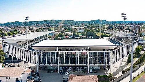
Alfred Armandie Stadium Manchu47 · CC0

Travel notes for Lot-et-Garonne
From Wikivoyage
Lot-et-Garonne is in Nouvelle-Aquitaine. The department is full of small picturesque villages such as a fortified mill in Barbaste or a miraculous spring in Ambrus.
Understand+
Its landscape is a vast limestone plateau eroded by rivers, with two very wide valleys: that of the Lot and that of the Garonne. The rest of the landscape is quite hilly but with some limestone vestiges beyond which are witnesses of erosion. Villages include:
1 Agen — a 12th-century cathedral with a double nave, and art gallery, a canal.
2 Duras — the Château de Duras dates from the 17th century.
3 Marmande — the church of Notre-Dame, which dates from the 13th, 14th and 15th centuries.
4 Monflanquin — ranked among the most beautiful villages in France.
5 Nérac — home to the Roman ruins of Nérac.
6 Villeneuve-sur-Lot — the largest of the bastides in the south-west.
Source: Wikivoyage · CC BY-SA 4.0 · abridged
Places bordering Lot-et-Garonne
- Dordogne
- Gironde
- Landes
Population of Lot-et-Garonne over time
| 2015 | 333,417 | |
|---|---|---|
| 2017 | 332,842 | |
| 2018 | 331,970 | |
| 2019 | 331,271 | |
| 2020 | 330,844 | |
| 2021 | 331,229 | |
| 2022 | 332,226 | |
| 2023 | 333,602 |
Censuses and official estimates; source: Wikidata.
Climate of Lot-et-Garonne
Best months for sightseeingBest months for sightseeing: June–September.
This month · November
Outside the best season
Day 12° · Night 4° · Rain 94 mm
- Hottest month
- July (day 26°)
- Coldest month
- January (night 1°)
- Wettest month
- November (94 mm)
- Driest month
- July (57 mm)
Bars: average monthly low and high temperature. Below: precipitation. Monthly averages for 1970–2000 at about 18 km resolution, adjusted for elevation. Highlighted months are mild and relatively dry. Source: WorldClim 2.1 (CC BY 4.0).
Show values as a table
| Month | Jan | Feb | Mar | Apr | May | Jun | Jul | Aug | Sep | Oct | Nov | Dec |
|---|---|---|---|---|---|---|---|---|---|---|---|---|
| Average high (°C) | 9° | 11° | 14° | 16° | 20° | 23° | 26° | 26° | 23° | 18° | 12° | 9° |
| Average low (°C) | 1° | 2° | 3° | 5° | 9° | 12° | 14° | 14° | 11° | 8° | 4° | 2° |
| Precipitation (mm) | 86 | 83 | 71 | 83 | 89 | 69 | 57 | 62 | 75 | 85 | 94 | 90 |
Other places to visit in this season: June July August September
How to get to Lot-et-Garonne
The nearest airport is Bergerac Dordogne-Périgord airport (EGC), 55 km to the north as the crow flies. For international flights: Toulouse-Blagnac Airport (TLS) (105 km). The nearest large city is Bordeaux, 103 km to the northwest.
Airports
- Bergerac Dordogne-Périgord airport (EGC) Bergerac 55 kmnorth
- Toulouse-Blagnac Airport (TLS) Toulouse/Blagnac 105 kmsoutheast
- Brive Souillac airport (BVE) Brive 111 kmnortheast
Nearby large cities
- Bordeaux Population: 265.3K 103 kmnorthwest
- Toulouse Population: 511.7K 111 kmsoutheast
- Limoges Population: 141.2K 177 kmnorth
- Donostia / San Sebastian Population: 185.4K 229 kmsouthwest
- Pamplona Population: 208.2K 242 kmsouthwest
Straight-line distances; road distances are longer. Airport data: OurAirports.
Day trips from Lot-et-Garonne
Within 100 km: 67 historic and cultural sites, 36 natural sites, 239 lakes, rivers and coasts.
0–25 km25 places
- Bois de Verteuil Natural site 19 kmN
- Tolzac River 15 kmNW
- Tolzac River 20 kmNW
- Séoune River 24 kmSE
25–60 km78 places
- Forêt du Mas d'Agenais et de Senestis Natural site 26 kmW
- Forêt Domaniale de Campet Natural site 31 kmSW
- Forêt de la Bessede Natural site 59 kmNE
- Lescouroux River 38 kmN
60–100 km239 places
- Base de loisirs de Bouconne Natural site 94 kmSE
- Forêt de Montaigut Natural site 95 kmSE
- Pech de Dreuilles Mountain 89 kmNE
- Bois du Turc Natural site 91 kmS
Straight-line distances.
Places in Lot-et-Garonne
50 places- 1 Arrondissement of Agen 119.8K
- 2 Arrondissement of Villeneuve-sur-Lot 89.7K
- 3 Arrondissement of Marmande 84.2K
- 4 Arrondissement of Nérac 38.5K
Bar: population relative to the most populous place in this list.
Mountains & nature3
- Bois de Verteuil · Natural site
- Forêt Domaniale de Campet · Natural site
- Forêt du Mas d'Agenais et de Senestis · Natural site
Lakes, rivers & coasts43
- Auvignon · River
- Baïse River · River
- Barraca · River
- Braysse · River
- Canaule · River
- Dourdène · River
- Gélise · River
- Gers · River
- Jorle · River
- Lagardonne · River
- Lauzoue · River
- Lède · River
- Lémance · River
- Lot · River
- Masse · River
- Osse · River
- Petite Séoune · River
- Ruisseau de Cougouze · River
- Ruisseau de Faget · River
- Ruisseau de Ganteraine · River
- Ruisseau de Lagaubège · River
- Ruisseau de la Gueyze · River
- Ruisseau de Lartigue · River
- Ruisseau de l'Auroue · River
- Ruisseau de Laussou · River
- Ruisseau de l'Avance · River
- Ruisseau de Lourbise · River
- Ruisseau de Saint-Martin · River
- Ruisseau de Salabert · River
- Ruisseau du Tren · River
- Ruisseau la Dourdèxe · River
- Ruisseau la Gupie · River
- Ruisseau le Boudouyssou · River
- Ruisseau le Brimont · River
- Ruisseau le Caubon · River
- Ruisseau le Grand Auvignon · River
- Ruisseau le Petit Auvignon · River
- Ruisseau le Rose · River
- Ruisseau Sérac · River
- Séoune · River
- Tolzac · River
- Tolzac · River
- Trec · River
Nature and heritage in Lot-et-Garonne
Sources & licences
Data last updated: · 2 independent sources