- Population
- 225,544
- 225.5K
- Elevation
- 150 m
- above sea level
- Local time
- UTC+01:00
- Europe/Paris · UTC+01:00
- Places inside
- 297
- listed under Arrondissement of Bernay
- Airports
- DOL Deauville Normandie airport45 km
- CFR Caen Carpiquet airport80 km
About Arrondissement of Bernay
Arrondissement of Bernay is a municipality. Location: Eure, Normandy. Population: 225,544. Elevation: 150 m. The best months to visit are June–September. The nearest airport is Deauville Normandie airport (45 km). Nearby sights include Charentonne River and Forêt de Beaumont.
Photos of Arrondissement of Bernay
-
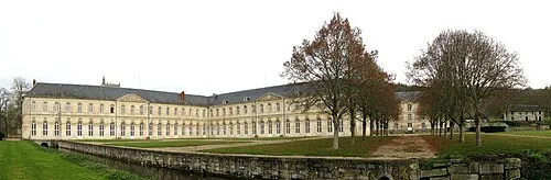
Bec Abbey Roland Brierre · CC BY-SA 3.0

Climate of Arrondissement of Bernay
Best months for sightseeingBest months for sightseeing: June–September.
This month · November
A cold month
Day 10° · Night 5° · Rain 73 mm
- Hottest month
- August (day 22°)
- Coldest month
- February (night 2°)
- Wettest month
- December (77 mm)
- Driest month
- July (49 mm)
Bars: average monthly low and high temperature. Below: precipitation. Monthly averages for 1970–2000 at about 18 km resolution, adjusted for elevation. Highlighted months are mild and relatively dry. Source: WorldClim 2.1 (CC BY 4.0).
Show values as a table
| Month | Jan | Feb | Mar | Apr | May | Jun | Jul | Aug | Sep | Oct | Nov | Dec |
|---|---|---|---|---|---|---|---|---|---|---|---|---|
| Average high (°C) | 7° | 7° | 10° | 13° | 16° | 19° | 22° | 22° | 19° | 15° | 10° | 8° |
| Average low (°C) | 2° | 2° | 3° | 5° | 8° | 11° | 13° | 13° | 11° | 8° | 5° | 3° |
| Precipitation (mm) | 70 | 62 | 54 | 51 | 57 | 55 | 49 | 50 | 59 | 75 | 73 | 77 |
Other places to visit in this season: June July August September
How to get to Arrondissement of Bernay
The nearest airport is Deauville Normandie airport (DOL), 45 km to the northwest as the crow flies. For international flights: Beauvais-Tillé airport (BVA) (114 km). The nearest large city is Rouen, 50 km to the northeast.
Airports
- Deauville Normandie airport (DOL) Deauville 45 kmnorthwest
- Caen Carpiquet airport (CFR) Caen 80 kmwest
- Beauvais-Tillé airport (BVA) Beauvais 114 kmeast
Nearby large cities
- Rouen Population: 116.3K 50 kmnortheast
- Le Havre Population: 186K 58 kmnorthwest
- Caen Population: 110.6K 73 kmwest
- Cergy-Pontoise Population: 183.4K 105 kmeast
- Saint-Quentin-en-Yvelines Population: 146.6K 108 kmeast
Straight-line distances; road distances are longer. Airport data: OurAirports.
Day trips from Arrondissement of Bernay
Within 100 km: 245 historic and cultural sites, 129 natural sites, 129 lakes, rivers and coasts.
0–25 km10 places
- Forêt de Conches Natural site 25 kmSE
- Forêt de Cinglais Natural site 22 kmSW
- Bois de Broglie Natural site 12 kmS
- Forêt de Beaumont Natural site 11 kmSE
25–60 km175 places
- Biotropica Natural site 47 kmNE
- Plage du Temple Beach 57 kmW
- Plage du Casino Beach 56 kmNW
- Plage de Deauville Beach 50 kmNW
60–100 km318 places
- Dive River 99 kmS
- Cloche River 87 kmS
- Gold Beach Beach 89 kmW
- Juno Beach Beach 82 kmW
Straight-line distances.
Arrondissement of Bernay and similar cities
Side by side with cities of similar size in the same country: population, elevation and climate.
| Measure | Arrondissement of Bernay | Rennes | Paris 15 Vaugirard | Lille |
|---|---|---|---|---|
| Population | 225.5K | 227.8K | 229.7K | 238.7K |
| Elevation | 150 m | 39 m | 47 m | 20 m |
| Summer day (hottest month) | 22° | 24° | 25° | 23° |
| Winter night (coldest month) | 2° | 3° | 2° | 1° |
| Annual rainfall | 732 mm | 738 mm | 632 mm | 716 mm |
| Best months | Jun–Sep | Jun–Sep | May–Sep | Jun–Aug |
| Distance | — | 203 km | 125 km | 243 km |
Climate values are 1970–2000 monthly averages; straight-line distance.
Places in Arrondissement of Bernay
297 places- 181 Le Tremblay-Omonville 337
- 182 Franqueville 335
- 183 Fontaine-la-Louvet 334
- 184 Le Plessis-Sainte-Opportune 334
- 185 Triqueville 334
- 186 Saint-Grégoire-du-Vièvre 323
- 187 Aclou 322
- 188 Mandeville 322
- 189 Saint-Victor-d'Épine 322
- 190 Saint-Siméon 321
- 191 Saint-Martin-Saint-Firmin 320
- 192 Romilly-la-Puthenaye 319
- 193 Bacquepuis 317
- 194 Bérengeville-la-Campagne 316
- 195 Asnières 309
- 196 Thibouville 307
- 197 La Haye-de-Routot 305
- 198 Berthouville 304
- 199 Criquebeuf-la-Campagne 304
- 200 Graveron-Sémerville 299
- 201 Saint-Paul-de-Fourques 299
- 202 La Haye-du-Theil 298
- 203 Éturqueraye 291
- 204 Saint-Meslin-du-Bosc 287
- 205 Boisney 285
- 206 Bernienville 284
- 207 Villez-sur-le-Neubourg 284
- 208 Saint-Pierre-des-Ifs 278
- 209 La Haye-Saint-Sylvestre 277
- 210 La Haye-de-Calleville 269
- 211 La Noë-Poulain 265
- 212 Les Barils 260
- 213 Malleville-sur-le-Bec 258
- 214 Bonneville-Aptot 256
- 215 Le Theil-Nolent 253
- 216 Saint-Pierre-de-Salerne 250
- 217 Saint-Sylvestre-de-Cormeilles 250
- 218 Le Tilleul-Lambert 248
- 219 Saint-Jean-du-Thenney 244
- 220 Berville-la-Campagne 243
- 221 La Trinité-de-Réville 241
- 222 Saint-Martin-du-Tilleul 240
- 223 Cauverville-en-Roumois 234
- 224 Daubeuf-la-Campagne 232
- 225 Le Bois-Hellain 231
- 226 Chaise-Dieu-du-Theil 227
- 227 Le Noyer-en-Ouche 227
- 228 Hectomare 223
- 229 Le Bec-Thomas 220
- 230 Saint-Pierre-de-Cernières 219
- 231 Notre-Dame-du-Hamel 216
- 232 Juignettes 213
- 233 La Houssaye 210
- 234 Saint-Denis-des-Monts 209
- 235 Saint-Cyr-de-Salerne 207
- 236 Houetteville 204
- 237 Verneusses 204
- 238 Le Landin 203
- 239 Colletot 202
- 240 Launay 202
Bar: population relative to the most populous place in this list.
Nearby attractions & nature
Everything nearby-
Charentonne River River, Eure6.9 km E
-
Forêt de Beaumont Natural site, Eure11 km SE
-
Bois de Broglie Natural site, Eure12 km S
-
Forêt de Conches Natural site, Eure25 km SE
-
Château de Mailloc Historic site, Valorbiquet24 km W
-
Forêt de Cinglais Natural site, Calvados22 km SW
Sources & licences
Data last updated: