- Population
- 577
- 577
- Elevation
- 6 m
- above sea level
- Local time
- UTC+01:00
- Europe/Paris · UTC+01:00
- Places inside
- 2
- listed under Barfleur
- Airports
- ACI Alderney Airport69 km
- CFR Caen Carpiquet airport80 km
About Barfleur
Barfleur is a village. Location: Arrondissement of Cherbourg, Manche. Population: 577. Elevation: 6 m. The best months to visit are June–September. The nearest airport is Alderney Airport (69 km). Nearby sights include Pointe de Barfleur Light and Anse de Gattemare.
Photos of Barfleur
-
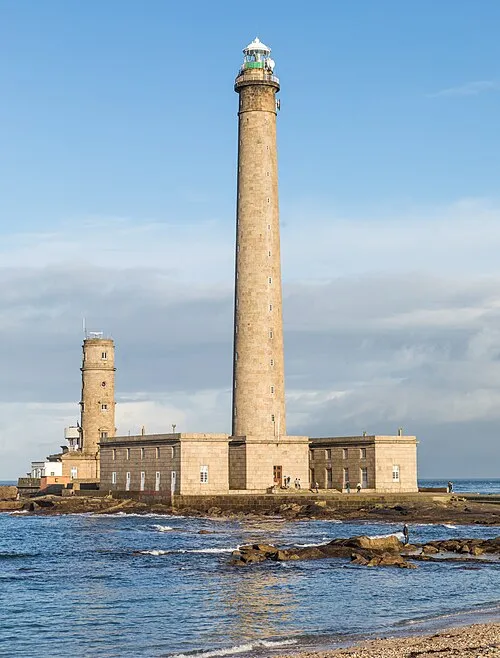
Pointe de Barfleur Light Raimond Spekking · CC BY-SA 4.0

Climate of Barfleur
Best months for sightseeingBest months for sightseeing: June–September.
This month · November
A wet month
Day 12° · Night 7° · Rain 104 mm
- Hottest month
- August (day 21°)
- Coldest month
- February (night 4°)
- Wettest month
- November (104 mm)
- Driest month
- July (43 mm)
Bars: average monthly low and high temperature. Below: precipitation. Monthly averages for 1970–2000 at about 18 km resolution, adjusted for elevation. Highlighted months are mild and relatively dry. Source: WorldClim 2.1 (CC BY 4.0).
Show values as a table
| Month | Jan | Feb | Mar | Apr | May | Jun | Jul | Aug | Sep | Oct | Nov | Dec |
|---|---|---|---|---|---|---|---|---|---|---|---|---|
| Average high (°C) | 8° | 9° | 11° | 12° | 16° | 18° | 21° | 21° | 19° | 15° | 12° | 9° |
| Average low (°C) | 4° | 4° | 5° | 6° | 8° | 11° | 13° | 14° | 12° | 10° | 7° | 5° |
| Precipitation (mm) | 88 | 66 | 67 | 52 | 55 | 47 | 43 | 47 | 71 | 92 | 104 | 97 |
Other places to visit in this season: June July August September
How to get to Barfleur
The nearest airport is Alderney Airport (ACI), 69 km to the west as the crow flies. The nearest large city is Caen, 85 km to the southeast.
Airports
- Alderney Airport (ACI) Saint Anne 69 kmwest
- Caen Carpiquet airport (CFR) Caen 80 kmsoutheast
- Jersey Airport (JER) St. Peter 85 kmsouthwest
Nearby large cities
- Caen Population: 110.6K 85 kmsoutheast
- Le Havre Population: 186K 101 kmeast
- Bournemouth Population: 163.6K 125 kmnorth
- Portsmouth Population: 208.1K 126 kmnorth
- Poole Population: 151.5K 127 kmnorthwest
Straight-line distances; road distances are longer. Airport data: OurAirports.
Day trips from Barfleur
Within 100 km: 111 historic and cultural sites, 51 natural sites, 72 lakes, rivers and coasts.
0–25 km36 places
- Plage Collignon Beach 22 kmW
- Plage de Collignon Beach 21 kmW
- Plage de Bretteville Beach 19 kmW
- Plage de la Mondrée Beach 14 kmW
25–60 km77 places
- Ollonde River 48 kmSW
- Plage Napoléon Beach 26 kmW
- Omaha Beach Beach 44 kmSE
- Utah Beach Beach 29 kmS
60–100 km121 places
- La Nace Mountain 69 kmW
- Le Puits Gervais Mountain 70 kmW
- Gold Beach Beach 65 kmSE
- Juno Beach Beach 71 kmSE
Straight-line distances.
Places in Barfleur
2 placesBar: population relative to the most populous place in this list.
Cities & villages1
- La Bretonne · Village
Nearby attractions & nature
Everything nearby-
Pointe de Barfleur Light Landmark, Gatteville-le-Phare2.9 km N
-
Anse de Gattemare Natural site, Normandy3.7 km NW
-
Anse de Brévy Natural site, Normandy3.4 km SE
-
Anse du Hommet Natural site, Normandy4.3 km SE
-
Anse du Bret en Bas Natural site, Normandy4.6 km SE
-
Anse de la Mare Natural site, Normandy5.6 km SE
Sources & licences
Data last updated: