Mayronnes
Located in Arrondissement of Carcassonne, Aude Coordinates: 43°03′23″ N 2°31′30″ E
- Population
- 44
- 44
- Elevation
- 288 m
- above sea level
- Local time
- UTC+01:00
- Europe/Paris · UTC+01:00
- Places inside
- 4
- listed under Mayronnes
- Airports
- CCF Carcassonne Salvaza Airport25 km
- PGF Perpignan-Rivesaltes (Llabanère) Airport45 km
About Mayronnes
Mayronnes is a village. Location: Arrondissement of Carcassonne, Aude. Population: 44. Elevation: 288 m. The best months to visit are June–September. The nearest airport is Carcassonne Salvaza Airport (25 km). Nearby sights include Pech de Fel and Château de Termes.
Photos of Mayronnes
-
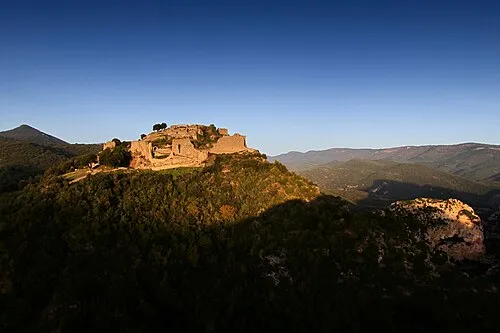
Château de Termes OlivierDeTermes · CC BY-SA 4.0

Climate of Mayronnes
Best months for sightseeingBest months for sightseeing: June–September.
This month · November
Outside the best season
Day 13° · Night 6° · Rain 61 mm
- Hottest month
- July (day 27°)
- Coldest month
- January (night 3°)
- Wettest month
- October (82 mm)
- Driest month
- July (23 mm)
Bars: average monthly low and high temperature. Below: precipitation. Monthly averages for 1970–2000 at about 18 km resolution, adjusted for elevation. Highlighted months are mild and relatively dry. Source: WorldClim 2.1 (CC BY 4.0).
Show values as a table
| Month | Jan | Feb | Mar | Apr | May | Jun | Jul | Aug | Sep | Oct | Nov | Dec |
|---|---|---|---|---|---|---|---|---|---|---|---|---|
| Average high (°C) | 9° | 10° | 13° | 15° | 19° | 23° | 27° | 26° | 23° | 18° | 13° | 10° |
| Average low (°C) | 3° | 3° | 5° | 7° | 10° | 14° | 16° | 16° | 13° | 10° | 6° | 4° |
| Precipitation (mm) | 67 | 58 | 56 | 64 | 67 | 46 | 23 | 42 | 55 | 82 | 61 | 75 |
Other places to visit in this season: June July August September
How to get to Mayronnes
The nearest airport is Carcassonne Salvaza Airport (CCF), 25 km to the northwest as the crow flies. The nearest large city is Perpignan, 50 km to the southeast.
Airports
- Carcassonne Salvaza Airport (CCF) Carcassonne 25 kmnorthwest
- Perpignan-Rivesaltes (Llabanère) Airport (PGF) Perpignan/Rivesaltes 45 kmsoutheast
- Castres Mazamet Airport (DCM) Castres 59 kmnorth
Nearby large cities
- Perpignan Population: 110.7K 50 kmsoutheast
- Toulouse Population: 511.7K 107 kmnorthwest
- Girona Population: 100.3K 122 kmsouth
- Montpellier Population: 248.3K 126 kmnortheast
- Mataró Population: 127K 168 kmsouth
Straight-line distances; road distances are longer. Airport data: OurAirports.
Day trips from Mayronnes
Within 100 km: 126 historic and cultural sites, 1,109 natural sites, 219 lakes, rivers and coasts.
0–25 km126 places
- Roque Sestière Mountain 22 kmE
- Pla de Saint-Paul Mountain 24 kmS
- Pech de Fraysse Mountain 21 kmSE
- Pech de la Coupe Mountain 5 kmSW
25–60 km346 places
- Torreilles Plage Beach 53 kmSE
- Plage des Chalets Beach 48 kmE
- Plage de la Vieille Nouvelle Beach 45 kmE
- Île Sainte-Lucie Island 42 kmE
60–100 km982 places
- Platja de Perafita Beach 84 kmSE
- Puig Joan Mountain 83 kmSE
- Platja de Canyelles Beach 91 kmSE
- Platja del Borró Beach 91 kmSE
Straight-line distances.
Places in Mayronnes
4 placesCities & villages1
- Mayronnes · Village
Mountains & nature3
- Pech Arnaud · Mountain
- Pech de Terri · Mountain
- Serre de la Pène · Mountain
Nearby attractions & nature
Everything nearby-
Pech de Fel Mountain, Vignevieille2.6 km S
-
Château de Termes Historic site, Termes6.5 km SE
-
Château de Durfort Historic site, Vignevieille4.2 km SE
-
Pech de la Coupe Mountain, Clermont-sur-Lauquet5.4 km SW
-
le Carla Mountain, Lagrasse5.5 km NE
-
Pic Berlès Mountain, Vignevieille6.8 km S
Sources & licences
Data last updated: