- Population
- 39,677
- 39.7K
- Elevation
- 508 m
- above sea level
- Local time
- UTC+01:00
- Europe/Paris · UTC+01:00
- Places inside
- 74
- listed under Arrondissement of Le Vigan
- Airports
- MPL Montpellier-Méditerranée Airport53 km
- FNI Nîmes-Arles-Camargue Airport63 km
About Arrondissement of Le Vigan
Arrondissement of Le Vigan is a municipality. Location: Gard, Occitanie. Population: 39,677. Elevation: 508 m. The best months to visit are June–September. The nearest airport is Montpellier-Méditerranée Airport (53 km). Nearby sights include Arre and Mont Brion.
Photos of Arrondissement of Le Vigan
-
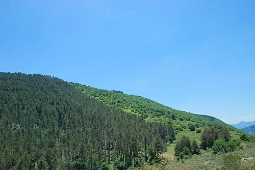
Montagne de la Fage Anthony Morel · CC BY-SA 4.0

Climate of Arrondissement of Le Vigan
Best months for sightseeingBest months for sightseeing: June–September.
This month · November
A cold month
Day 11° · Night 4° · Rain 76 mm
- Hottest month
- July (day 25°)
- Coldest month
- January (night 1°)
- Wettest month
- October (121 mm)
- Driest month
- July (33 mm)
Bars: average monthly low and high temperature. Below: precipitation. Monthly averages for 1970–2000 at about 18 km resolution, adjusted for elevation. Highlighted months are mild and relatively dry. Source: WorldClim 2.1 (CC BY 4.0).
Show values as a table
| Month | Jan | Feb | Mar | Apr | May | Jun | Jul | Aug | Sep | Oct | Nov | Dec |
|---|---|---|---|---|---|---|---|---|---|---|---|---|
| Average high (°C) | 8° | 9° | 11° | 14° | 18° | 22° | 25° | 25° | 21° | 16° | 11° | 9° |
| Average low (°C) | 1° | 2° | 3° | 5° | 9° | 13° | 15° | 15° | 12° | 9° | 4° | 2° |
| Precipitation (mm) | 82 | 62 | 54 | 73 | 74 | 52 | 33 | 52 | 75 | 121 | 76 | 78 |
Other places to visit in this season: June July August September
How to get to Arrondissement of Le Vigan
The nearest airport is Montpellier-Méditerranée Airport (MPL), 53 km to the south as the crow flies. The nearest large city is Montpellier, 48 km to the south.
Airports
- Montpellier-Méditerranée Airport (MPL) Montpellier/Méditerranée 53 kmsouth
- Nîmes-Arles-Camargue Airport (FNI) Nîmes/Garons 63 kmsoutheast
- Béziers Vias airport (BZR) Béziers 84 kmsouth
Nearby large cities
- Montpellier Population: 248.3K 48 kmsouth
- Nîmes Population: 148.2K 55 kmsoutheast
- Aix-en-Provence Population: 146.8K 149 kmeast
- Marseille Population: 877.2K 156 kmsoutheast
- Perpignan Population: 110.7K 162 kmsouthwest
Straight-line distances; road distances are longer. Airport data: OurAirports.
Day trips from Arrondissement of Le Vigan
Within 100 km: 138 historic and cultural sites, 465 natural sites, 224 lakes, rivers and coasts.
0–25 km101 places
- Drus Mountain 18 kmE
- Puech de Mar Mountain 13 kmSE
- Roc des Pézouls Mountain 16 kmSW
- Roc Blanc - la Seranne Mountain 19 kmSW
25–60 km204 places
- Plage du Couchant Beach 59 kmSE
- Plage du Grand Travers Beach 58 kmSE
- Plage du Pilou Beach 59 kmS
- Étang du Prévost Lake 58 kmS
60–100 km522 places
- Alba-la-Romaine (Ardèche, France) -- Théâtre gallo-romain Historic site 91 kmNE
- Marseillan Plage Beach 80 kmS
- Plage de Beauduc Beach 99 kmSE
- Plage de l'Espiguette Beach 66 kmSE
Straight-line distances.
Places in Arrondissement of Le Vigan
74 places- 1 Le Vigan 3.9K
- 2 Saint-Hippolyte-du-Fort 3.7K
- 3 Quissac 3.5K
- 4 Sauve 2K
- 5 Lédignan 1.5K
- 6 Sumène 1.2K
- 7 Lasalle 1.2K
- 8 Val-d'Aigoual 1.1K
- 9 Avèze 1.1K
- 10 Molières-Cavaillac 944
- 11 Cardet 933
- 12 Pompignan 908
- 13 Monoblet 787
- 14 Aigremont 782
- 15 Durfort-et-Saint-Martin-de-Sossenac 685
- 16 Corconne 620
- 17 Saint-André-de-Majencoules 601
- 18 Bréau-Mars 599
- 19 Carnas 537
- 20 Saint-Théodorit 522
- 21 Vic-le-Fesq 510
- 22 Aulas 456
- 23 Orthoux-Sérignac-Quilhan 440
- 24 Cassagnoles 430
- 25 Canaules-et-Argentières 425
- 26 Saint-André-de-Valborgne 396
- 27 Mandagout 368
- 28 Sardan 347
- 29 Saint-Laurent-le-Minier 342
- 30 Bez-et-Esparon 341
- 31 Lanuéjols 341
- 32 Liouc 330
- 33 Gailhan 313
- 34 Saumane 303
- 35 Saint-Bénézet 290
- 36 Brouzet-lès-Quissac 286
- 37 Logrian-Florian 270
- 38 Soudorgues 269
- 39 Roquedur 266
- 40 Saint-Jean-de-Crieulon 264
- 41 Aumessas 263
- 42 Cros 256
- 43 Arre 252
- 44 Saint-Félix-de-Pallières 249
- 45 Savignargues 238
- 46 Maruéjols-lès-Gardon 234
- 47 Les Plantiers 228
- 48 Arrigas 219
- 49 Colognac 209
- 50 La Cadière-et-Cambo 209
- 51 Montdardier 209
- 52 Saint-Sauveur-Camprieu 207
- 53 Alzon 194
- 54 Bragassargues 177
- 55 Dourbies 177
- 56 Saint-Martial 177
- 57 Fressac 163
- 58 Saint-Roman-de-Codières 160
- 59 L'Estréchure 151
- 60 Blandas 143
Bar: population relative to the most populous place in this list.
Nearby attractions & nature
Everything nearby-
Arre River, Gard5.4 km SW
-
Mont Brion Mountain, Sainte-Croix-de-Caderle11 km NE
-
Pic de Montvaillant Mountain, Sainte-Croix-de-Caderle13 km E
-
Bois de Banc Natural site, Gard14 km E
-
Vis River, Hérault10 km S
-
Bois de Tessonne Natural site, Gard15 km SW
-
Bois de Monié Natural site, Gard16 km SE
-
Bois de Montmal Natural site, Hérault14 km S
Other cities and towns in Gard
-
Arrondissement of Alès Municipality, Gard35 km NE
-
Arrondissement of Nîmes Municipality, Gard57 km E
-
Alès Town, Alès30 km E
-
Saint-Christol-les-Alès Town, Saint-Christol-lez-Alès29 km E
-
 Nîmes City, Nîmes55 km SE
-
Vauvert Town, Vauvert57 km SE
Sources & licences
Data last updated: