- Population
- 13,093
- 13.1K
- Elevation
- 1,063 m
- above sea level
- Local time
- UTC+01:00
- Europe/Paris · UTC+01:00
- Places inside
- 38
- listed under Arrondissement of Florac
- Airports
- MPL Montpellier-Méditerranée Airport85 km
- RDZ Rodez–Aveyron Airport87 km
About Arrondissement of Florac
Arrondissement of Florac is a municipality. Location: Lozère, Occitanie. Population: 13,093. Elevation: 1,063 m. The best months to visit are July–August. The nearest airport is Montpellier-Méditerranée Airport (85 km). Nearby sights include Mimento and Tarnon.
Photos of Arrondissement of Florac
-
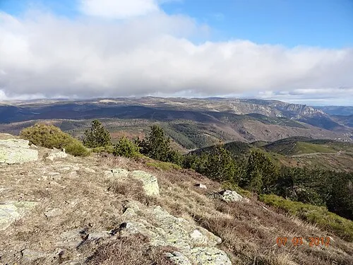
Signal de Ventalon Camillelecat · CC BY-SA 3.0

Climate of Arrondissement of Florac
Best months for sightseeingBest months for sightseeing: July–August.
This month · November
A wet month
Day 7° · Night 1° · Rain 100 mm
- Hottest month
- July (day 22°)
- Coldest month
- January (night -3°)
- Wettest month
- October (144 mm)
- Driest month
- July (40 mm)
Bars: average monthly low and high temperature. Below: precipitation. Monthly averages for 1970–2000 at about 18 km resolution, adjusted for elevation. Highlighted months are mild and relatively dry. Source: WorldClim 2.1 (CC BY 4.0).
Show values as a table
| Month | Jan | Feb | Mar | Apr | May | Jun | Jul | Aug | Sep | Oct | Nov | Dec |
|---|---|---|---|---|---|---|---|---|---|---|---|---|
| Average high (°C) | 4° | 5° | 8° | 10° | 14° | 18° | 22° | 22° | 18° | 13° | 7° | 5° |
| Average low (°C) | -3° | -2° | -1° | 1° | 5° | 8° | 11° | 11° | 8° | 5° | 1° | -2° |
| Precipitation (mm) | 104 | 80 | 68 | 89 | 92 | 64 | 40 | 60 | 88 | 144 | 100 | 99 |
How to get to Arrondissement of Florac
The nearest airport is Montpellier-Méditerranée Airport (MPL), 85 km to the south as the crow flies. The nearest large city is Montpellier, 79 km to the south.
Airports
- Montpellier-Méditerranée Airport (MPL) Montpellier/Méditerranée 85 kmsouth
- Rodez–Aveyron Airport (RDZ) Rodez/Marcillac 87 kmwest
- Nîmes-Arles-Camargue Airport (FNI) Nîmes/Garons 90 kmsoutheast
Nearby large cities
- Montpellier Population: 248.3K 79 kmsouth
- Nîmes Population: 148.2K 81 kmsoutheast
- Saint-Etienne Population: 176.3K 143 kmnortheast
- Clermont-Ferrand Population: 147.9K 170 kmnorth
- Aix-en-Provence Population: 146.8K 173 kmsoutheast
Straight-line distances; road distances are longer. Airport data: OurAirports.
Day trips from Arrondissement of Florac
Within 100 km: 125 historic and cultural sites, 582 natural sites, 212 lakes, rivers and coasts.
0–25 km48 places
- Montagne de Ramponenche Mountain 9 kmNE
- Mont Lozère - Sommet de Finiels Mountain 21 kmNE
- Eschino d'Ase Mountain 12 kmN
- Signal du Bougès Mountain 13 kmE
25–60 km273 places
- Lac de Charpal Lake 38 kmN
- Lac du barrage de Naussac Lake 54 kmN
- Drus Mountain 43 kmSE
- Puech de Mar Mountain 44 kmSE
60–100 km598 places
- Alba-la-Romaine (Ardèche, France) -- Théâtre gallo-romain Historic site 88 kmE
- Plage de l'Espiguette Beach 98 kmSE
- Plage du Couchant Beach 91 kmSE
- Plage du Grand Travers Beach 90 kmSE
Straight-line distances.
Places in Arrondissement of Florac
38 places- 1 Florac Trois Rivières 2.1K
- 2 Massegros Causses Gorges 936
- 3 Ispagnac 895
- 4 Gorges du Tarn Causses 881
- 5 Le Collet-de-Dèze 776
- 6 Meyrueis 770
- 7 Pont de Montvert - Sud Mont Lozère 594
- 8 Saint-Étienne-Vallée-Française 512
- 9 Bédouès-Cocurès 457
- 10 Saint-Germain-de-Calberte 456
- 11 Vialas 447
- 12 Cans et Cévennes 288
- 13 Sainte-Croix-Vallée-Française 279
- 14 Hures-la-Parade 260
- 15 Saint-Michel-de-Dèze 248
- 16 Saint-Privat-de-Vallongue 233
- 17 Vebron 225
- 18 Ventalon en Cévennes 221
- 19 Moissac-Vallée-Française 216
- 20 Barre-des-Cévennes 205
- 21 Saint-Martin-de-Boubaux 194
- 22 Saint-Martin-de-Lansuscle 192
- 23 Le Pompidou 184
- 24 Les Bondons 139
- 25 Le Rozier 136
- 26 La Malène 130
- 27 Saint-André-de-Lancize 126
- 28 Cassagnas 125
- 29 Saint-Julien-des-Points 121
- 30 Rousses 119
- 31 Mas-Saint-Chély 116
- 32 Gabriac 102
- 33 Saint-Hilaire-de-Lavit 101
- 34 Molezon 99
- 35 Saint-Pierre-des-Tripiers 84
- 36 Fraissinet-de-Fourques 83
- 37 Bassurels 62
- 38 Gatuzières 52
Bar: population relative to the most populous place in this list.
Nearby attractions & nature
Everything nearby-
Mimento River, Lozère4.3 km NE
-
Tarnon River, Lozère5.8 km N
-
Ruisseau de Trépalaux River, Lozère6.5 km S
-
Ruisseau de Mirals River, Lozère9.5 km NE
-
Bois d'Altefage Natural site, Lozère13 km E
-
Ruisseau la Brousse River, Lozère13 km NE
-
Ruisseau de Malzac River, Lozère13 km E
-
Forêt de l'Aigoual Natural site, Lozère18 km S
Sources & licences
Data last updated: