Falleron
Located in Loire-Atlantique, Pays de la Loire Region Coordinates: 47°01′45″ N 1°58′50″ W
- Elevation
- 2 m
- above sea level
- Local time
- UTC+01:00
- Europe/Paris · UTC+01:00
- Airports
- NTE Nantes Atlantique Airport31 km
- LRH La Rochelle Île de Ré Airport112 km
About Falleron
Falleron is a river. Location: Loire-Atlantique, Pays de la Loire Region. The best months to visit are June–September. The nearest airport is Nantes Atlantique Airport (31 km). Nearby sights include Île de Bouin and Étier de la Salle.
Photos of Falleron
-
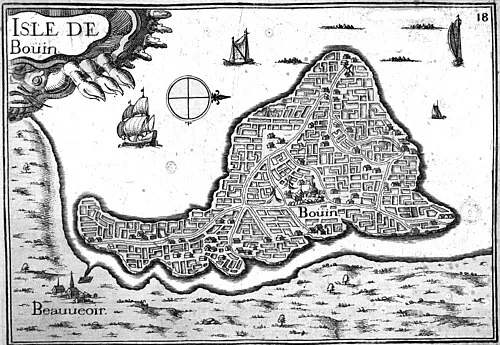
Île de Bouin Christophe Tassin · Public domain

Climate of Falleron
Best months for sightseeingBest months for sightseeing: June–September.
This month · November
Outside the best season
Day 12° · Night 6° · Rain 90 mm
- Hottest month
- August (day 24°)
- Coldest month
- January (night 3°)
- Wettest month
- November (90 mm)
- Driest month
- June (40 mm)
Bars: average monthly low and high temperature. Below: precipitation. Monthly averages for 1970–2000 at about 18 km resolution, adjusted for elevation. Highlighted months are mild and relatively dry. Source: WorldClim 2.1 (CC BY 4.0).
Show values as a table
| Month | Jan | Feb | Mar | Apr | May | Jun | Jul | Aug | Sep | Oct | Nov | Dec |
|---|---|---|---|---|---|---|---|---|---|---|---|---|
| Average high (°C) | 9° | 10° | 13° | 15° | 19° | 22° | 24° | 24° | 21° | 17° | 12° | 10° |
| Average low (°C) | 3° | 3° | 5° | 7° | 10° | 12° | 15° | 14° | 12° | 10° | 6° | 4° |
| Precipitation (mm) | 86 | 73 | 57 | 56 | 59 | 40 | 41 | 40 | 65 | 81 | 90 | 90 |
Other places to visit in this season: June July August September
How to get to Falleron
The nearest airport is Nantes Atlantique Airport (NTE), 31 km to the northeast as the crow flies. The nearest large city is Nantes, 39 km to the northeast.
Airports
- Nantes Atlantique Airport (NTE) Nantes 31 kmnortheast
- La Rochelle Île de Ré Airport (LRH) La Rochelle 112 kmsoutheast
- Rennes-Saint-Jacques Airport (RNS) Saint-Jacques-de-la-Lande, Ille-et-Vilaine 117 kmnorth
Nearby large cities
- Nantes Population: 325.1K 39 kmnortheast
- Angers Population: 168.3K 119 kmnortheast
- Rennes Population: 227.8K 122 kmnorth
- Le Mans Population: 144.5K 197 kmnortheast
- Tours Population: 141.6K 207 kmeast
Straight-line distances; road distances are longer. Airport data: OurAirports.
Day trips from Falleron
Within 100 km: 177 historic and cultural sites, 105 natural sites, 222 lakes, rivers and coasts.
0–25 km38 places
- Noirmoutier Island 22 kmW
- Plage de la Boutinardière Beach 9 kmNW
- Plage de la Birochère Beach 12 kmNW
- Plage de la Source Beach 12 kmNW
25–60 km150 places
- Île d'Yeu Island 45 kmSW
- Plage de la Courance Beach 32 kmNW
- Plage Sainte-Marguerite Beach 35 kmNW
- Plage de la Baule Beach 39 kmNW
60–100 km316 places
- Belle Île Island 97 kmW
- Plage Beg Lann Beach 78 kmNW
- Les Grands Sables Beach 91 kmW
- Plage de Kercambre Beach 82 kmNW
Straight-line distances.
Nearest towns and villages
-
Villeneuve-en-Retz Village, Arrondissement of Saint-Nazaire2.6 km NE
-
Port du Collet Village, Les Moutiers-en-Retz0.4 km E
-
Les Moutiers-en-Retz Village, Arrondissement of Saint-Nazaire4.1 km N
-
Les Moutiers-en-Retz Village, Les Moutiers-en-Retz4.1 km N
-
Bourgneuf-en-Retz Village, Villeneuve-en-Retz2.6 km NE
-
Bouin Village, Arrondissement of Les Sables-d'Olonne6.4 km S
Nearby attractions & nature
Everything nearby-
Île de Bouin Island, Vendée7.1 km S
-
Étier de la Salle River, Loire-Atlantique5.8 km SE
-
Plage de la Boutinardière Beach, La Bernerie-en-Retz9.1 km NW
-
Plage de la Birochère Beach, Pornic12 km NW
-
Plage de la Source Beach, Pornic12 km NW
-
Plage de la Noëveillard Beach, Pornic14 km NW
-
Île Cheviré Island, Loire-Atlantique22 km NE
-
Île de Bois Island, Loire-Atlantique24 km NE
More lakes, rivers and coasts in France
-
Île Pivin Island, Loire-Atlantique28 km NE
-
Île Pipy Island, Loire-Atlantique30 km N
-
Île de Lavau Island, Loire-Atlantique30 km N
-
Île Beaulieu Island, Loire-Atlantique38 km NE
-
 Île la Chenaie Island, Loire-Atlantique48 km NE
-
Plage de la Courance Beach, Saint-Nazaire32 km NW
Sources & licences
Data last updated: