Creglingen, Herrgottskirche
Located in Creglingen, Main-Tauber-Kreis Coordinates: 49°27′29″ N 10°01′54″ E
- Local time
- UTC+01:00
- Europe/Berlin · UTC+01:00
- Elevation
- 314 m
- above sea level
- Airports
- NUE Nuremberg Airport76 km
- STR Stuttgart Airport104 km
About Creglingen, Herrgottskirche
Creglingen, Herrgottskirche is a tourist attraction. Location: Creglingen, Main-Tauber-Kreis. The best months to visit are June–September. The nearest airport is Nuremberg Airport (76 km). Nearby sights include Bockstall and Herrgottsbach.
Photos of Creglingen, Herrgottskirche
-
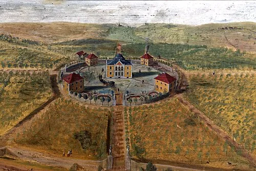
Karlsberg Holger Uwe Schmitt · CC BY-SA 4.0

Climate of Creglingen, Herrgottskirche
Best months for sightseeingBest months for sightseeing: June–September.
This month · November
A cold month
Day 7° · Night 1° · Rain 58 mm
- Hottest month
- August (day 24°)
- Coldest month
- January (night -2°)
- Wettest month
- June (77 mm)
- Driest month
- February (52 mm)
Bars: average monthly low and high temperature. Below: precipitation. Monthly averages for 1970–2000 at about 18 km resolution, adjusted for elevation. Highlighted months are mild and relatively dry. Source: WorldClim 2.1 (CC BY 4.0).
Show values as a table
| Month | Jan | Feb | Mar | Apr | May | Jun | Jul | Aug | Sep | Oct | Nov | Dec |
|---|---|---|---|---|---|---|---|---|---|---|---|---|
| Average high (°C) | 3° | 4° | 9° | 13° | 19° | 21° | 23° | 24° | 19° | 13° | 7° | 4° |
| Average low (°C) | -2° | -2° | 1° | 4° | 8° | 11° | 13° | 13° | 9° | 5° | 1° | -1° |
| Precipitation (mm) | 55 | 52 | 56 | 53 | 69 | 77 | 69 | 61 | 53 | 62 | 58 | 67 |
Other places to visit in this season: June July August September
How to get to Creglingen, Herrgottskirche
The nearest airport is Nuremberg Airport (NUE), 76 km to the east as the crow flies. The nearest large city is Würzburg, 38 km to the north.
Airports
- Nuremberg Airport (NUE) Nuremberg 76 kmeast
- Stuttgart Airport (STR) Stuttgart 104 kmsouthwest
- Mannheim-City Airport (MHG) Mannheim 110 kmwest
Nearby large cities
- Würzburg Population: 133.7K 38 kmnorth
- Heilbronn Population: 120.7K 69 kmsouthwest
- Fürth Population: 132K 69 kmeast
- Erlangen Population: 102.7K 72 kmeast
- Nuremberg Population: 515.5K 76 kmeast
Straight-line distances; road distances are longer. Airport data: OurAirports.
Day trips from Creglingen, Herrgottskirche
Within 100 km: 1,522 historic and cultural sites, 3,577 natural sites, 838 lakes, rivers and coasts.
0–25 km319 places
- Umpfer River 24 kmNW
- Uzbach River 14 kmNE
- Großer Lindleinsee Lake 15 kmSE
- Stausee Münster Lake 3 kmS
25–60 km1,626 places
- Hessental Concentration Camp Historic site 44 kmSW
- Badsee Lake 58 kmNE
- Wolfsee Lake 35 kmNE
- Tränksee Lake 39 kmNE
60–100 km3,992 places
- Elsenz River 90 kmW
- Zusam River 99 kmSE
- Lauter River 98 kmSW
- Neckarinsel Island 98 kmW
Straight-line distances.
Nearby attractions & nature
Everything nearby-
Bockstall Natural site, Baden-Wurttemberg2 km NW
-
Herrgottsbach River, Baden-Wurttemberg1.2 km N
-
Gemeindeholz Natural site, Baden-Wurttemberg3.1 km NE
-
Karlsberg Historic site, Weikersheim7.7 km W
-
Brauneck Historic site, Creglingen5.7 km N
-
Stausee Münster Lake, Baden-Wurttemberg3.4 km S
-
Bürgerwald Natural site, Bavaria4.5 km NW
-
Klosterwald Natural site, Baden-Wurttemberg4.5 km NE
Nearest towns and villages
-
Creglingen Village, Creglingen1.2 km N
-
Craintal Village, Creglingen1.7 km E
-
Münster Village, Creglingen1.8 km S
-
 Archshofen Village, Creglingen2.8 km E
Sources & licences
Data last updated: