
- Elevation
- 535 m
- above sea level
- Local time
- UTC+01:00
- Europe/Berlin · UTC+01:00
- Airports
- FDH Bodensee Airport Friedrichshafen33 km
- ACH Sankt Gallen Altenrhein Airport50 km
About Billafingen
Billafingen is a village. Location: Owingen, Bodenseekreis. Elevation: 535 m.
Billafingen is a village that is part of Owingen in the Bodensee district, Germany, close to Überlingen. It was first mentioned in 970 and merged with Owingen in 1975. Its population is around 700. It has won the village improvement competition "Unser Dorf soll schöner werden" ('Make our village more beautiful') several times.
Source: Wikipedia · CC BY-SA 4.0
At a glance
- Area
- 9.2 km²
Source: Wikidata
Photos of Billafingen
-

Merkler, Erich, Grosselfingen · CC BY 4.0 -

Alriester · CC BY 3.0 -
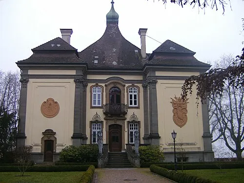
Schloß Rauenstein Mdpks · CC BY-SA 3.0 -
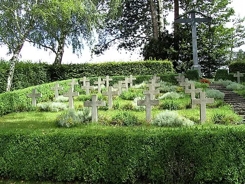
Überlingen Concentration Camp (Aufkirch) David W · Public domain


Climate of Billafingen
Best months for sightseeingBest months for sightseeing: June–August.
This month · November
A cold month
Day 6° · Night 1° · Rain 70 mm
- Hottest month
- July (day 23°)
- Coldest month
- January (night -3°)
- Wettest month
- June (108 mm)
- Driest month
- January (48 mm)
Bars: average monthly low and high temperature. Below: precipitation. Monthly averages for 1970–2000 at about 18 km resolution, adjusted for elevation. Highlighted months are mild and relatively dry. Source: WorldClim 2.1 (CC BY 4.0).
Show values as a table
| Month | Jan | Feb | Mar | Apr | May | Jun | Jul | Aug | Sep | Oct | Nov | Dec |
|---|---|---|---|---|---|---|---|---|---|---|---|---|
| Average high (°C) | 2° | 4° | 9° | 12° | 18° | 20° | 23° | 23° | 18° | 12° | 6° | 3° |
| Average low (°C) | -3° | -3° | 0° | 3° | 8° | 11° | 13° | 12° | 9° | 5° | 1° | -2° |
| Precipitation (mm) | 48 | 55 | 49 | 68 | 85 | 108 | 101 | 92 | 70 | 66 | 70 | 64 |
How to get to Billafingen
The nearest airport is Bodensee Airport Friedrichshafen (FDH), 33 km to the southeast as the crow flies. The nearest large city is Winterthur, 48 km to the southwest.
Airports
- Bodensee Airport Friedrichshafen (FDH) Friedrichshafen 33 kmsoutheast
- Sankt Gallen Altenrhein Airport (ACH) St. Gallen 50 kmsoutheast
- Zürich Airport (ZRH) Zurich 61 kmsouthwest
Nearby large cities
- Winterthur Population: 111.8K 48 kmsouthwest
- Zurich Population: 415.4K 68 kmsouthwest
- Reutlingen Population: 112.6K 74 kmnorth
- Ulm Population: 120.5K 89 kmnortheast
- Freiburg im Breisgau Population: 237.5K 98 kmwest
Straight-line distances; road distances are longer. Airport data: OurAirports.
Day trips from Billafingen
Within 100 km: 647 historic and cultural sites, 3,918 natural sites, 1,003 lakes, rivers and coasts.
0–25 km243 places
- Mainau Island 15 kmS
- Dominikanerinsel Konstanz Island 19 kmS
- Strandbad Steckborn Beach 23 kmSW
- Anderbach Lake 24 kmS
25–60 km1,163 places
- Insel Werd Island 28 kmSW
- Pfäffikersee Lake 60 kmSW
- Luppmenweiher Lake 57 kmSW
- Hasensee Lake 34 kmSW
60–100 km4,162 places
- Fahr Abbey Attraction 71 kmSW
- Arbeiterstrandbad Tennwil Beach 91 kmSW
- Ufenau Island 74 kmS
- Insel Lützelau Island 73 kmS
Straight-line distances.
Nearby attractions & nature
Everything nearby-
Kalvarienberg Mountain, Überlingen2.5 km W
-
Gertholz Natural site, Baden-Wurttemberg1.6 km SE
-
Hochbühl Mountain, Überlingen2.1 km S
-
Alter Hof Mountain, Owingen2.9 km E
-
Gneipensberg Mountain, Bodman-Ludwigshafen2.8 km E
-
Sipplinger Berg Mountain, Überlingen3.8 km SW
Sources & licences
Data last updated: · 2 independent sources