Eichelberg
Located in Scheinfeld, Landkreis Neustadt an der Aisch-Bad Windsheim Coordinates: 49°41′52″ N 10°30′21″ E
- Elevation
- 442 m
- above sea level
- Local time
- UTC+01:00
- Europe/Berlin · UTC+01:00
- Airports
- NUE Nuremberg Airport47 km
- FRA Frankfurt Main Airport145 km
About Eichelberg
Eichelberg is a mountain. Location: Scheinfeld, Landkreis Neustadt an der Aisch-Bad Windsheim. Elevation: 442 m. The best months to visit are June–August. The nearest airport is Nuremberg Airport (47 km). Nearby sights include Seitenbucher Ranken and Eichet.
Photos of Eichelberg
-
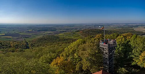
Steigerwald BeneFoto · CC BY-SA 4.0 -
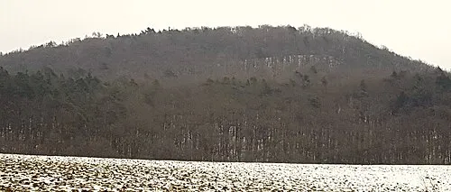
Rotes Hörnle Nico1995fcb · CC0


Climate of Eichelberg
Best months for sightseeingBest months for sightseeing: June–August.
This month · November
A cold month
Day 6° · Night 0° · Rain 60 mm
- Hottest month
- July (day 23°)
- Coldest month
- January (night -4°)
- Wettest month
- June (82 mm)
- Driest month
- February (51 mm)
Bars: average monthly low and high temperature. Below: precipitation. Monthly averages for 1970–2000 at about 18 km resolution, adjusted for elevation. Highlighted months are mild and relatively dry. Source: WorldClim 2.1 (CC BY 4.0).
Show values as a table
| Month | Jan | Feb | Mar | Apr | May | Jun | Jul | Aug | Sep | Oct | Nov | Dec |
|---|---|---|---|---|---|---|---|---|---|---|---|---|
| Average high (°C) | 2° | 3° | 8° | 12° | 18° | 21° | 23° | 23° | 18° | 12° | 6° | 3° |
| Average low (°C) | -4° | -4° | -1° | 2° | 6° | 10° | 11° | 11° | 7° | 3° | 0° | -2° |
| Precipitation (mm) | 59 | 51 | 57 | 52 | 65 | 82 | 76 | 57 | 55 | 62 | 60 | 69 |
How to get to Eichelberg
The nearest airport is Nuremberg Airport (NUE), 47 km to the southeast as the crow flies. The nearest large city is Erlangen, 38 km to the east.
Airports
- Nuremberg Airport (NUE) Nuremberg 47 kmsoutheast
- Frankfurt Main Airport (FRA) Frankfurt am Main 145 kmwest
- Stuttgart Airport (STR) Stuttgart 146 kmsouthwest
Nearby large cities
- Erlangen Population: 102.7K 38 kmeast
- Würzburg Population: 133.7K 41 kmwest
- Fürth Population: 132K 43 kmsoutheast
- Nuremberg Population: 515.5K 49 kmsoutheast
- Heilbronn Population: 120.7K 112 kmsouthwest
Straight-line distances; road distances are longer. Airport data: OurAirports.
Day trips from Eichelberg
Within 100 km: 1,382 historic and cultural sites, 3,858 natural sites, 769 lakes, rivers and coasts.
0–25 km565 places
- Wolfsee Lake 9 kmSW
- Tränksee Lake 11 kmNW
- Sperbersee Lake 12 kmSW
- Neusee Lake 24 kmN
25–60 km2,056 places
- Umpfer River 59 kmW
- Uzbach River 30 kmSW
- Badsee Lake 25 kmN
- Welles Weiher Lake 33 kmE
60–100 km3,388 places
- Waldstadion Weismain Landmark 69 kmNE
- Hessental Concentration Camp Historic site 85 kmSW
- Spitzelberg Mountain 70 kmE
- Stollenberg Mountain 68 kmE
Straight-line distances.
Nearest towns and villages
-
Scheinfeld Village, Scheinfeld4.3 km SW
-
Neuses Village, Scheinfeld0.8 km N
-
Markt Taschendorf, Markt Village, Landkreis Neustadt an der Aisch-Bad Windsheim3.2 km E
-
Markt Taschendorf Village, Markt Taschendorf, Markt3.6 km E
-
Kornhöfstadt Village, Scheinfeld1.2 km S
-
Seitenbuch Village, Burghaslach, Markt1.5 km NW
Nearby attractions & nature
Everything nearby-
Seitenbucher Ranken Mountain, Scheinfeld1.6 km W
-
Eichet Natural site, Bavaria1.3 km NE
-
Eichelberg Mountain, Burghaslach, Markt2.1 km NW
-
Lerchenbaum Natural site, Bavaria1.7 km S
-
Auwald Natural site, Bavaria1.8 km S
-
Vorderer Schloßberg Mountain, Oberscheinfeld, Markt2.7 km NW
-
Hohe Föhren Mountain, Markt Taschendorf, Markt3.1 km E
-
Eichenbuck Mountain, Scheinfeld3.3 km SW
Sources & licences
Data last updated: