- Population
- 301,105
- 301.1K
- Elevation
- 498 m
- above sea level
- Local time
- UTC+01:00
- Europe/Berlin · UTC+01:00
- Places inside
- 61
- listed under Augsburg
- Airports
- FMM Memmingen Allgau Airport64 km
- MUC Munich Airport66 km
About Augsburg
Augsburg is a village. Location: Kreisfreie Stadt Augsburg, Swabia. Population: 301,105. Elevation: 498 m.
Augsburg (UK: OWGZ-burg, also US: AWGZ-; German: [ˈaʊksbʊʁk] ; Swabian German: Ougschburg) is a city in the Bavarian part of Swabia, Germany, around 50 kilometres (31 mi) west of the Bavarian capital Munich. It is a university town and the regional seat of the Regierungsbezirk Swabia with a well-preserved Altstadt (historical city centre). Augsburg is an urban district and home to the institutions of the Landkreis Augsburg.
Source: Wikipedia · CC BY-SA 4.0
Photos of Augsburg
-
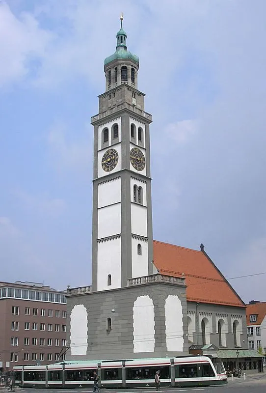
Perlach Tower Wikimedia Commons · CC BY-SA 3.0

Twin towns and sister cities of Augsburg
- Inverness· United Kingdom
- Amagasaki· Japan
- Nagahama· Japan
- Nagahama· Japan
Source: Wikidata. Only places with a page on this site are shown.
Population of Augsburg over time
| 2012 | 272,699 | |
|---|---|---|
| 2013 | 276,542 | |
| 2014 | 283,544 | |
| 2015 | 288,631 | |
| 2016 | 289,584 | |
| 2017 | 292,851 | |
| 2019 | 300,000 | |
| 2021 | 296,478 | |
| 2022 | 301,033 | |
| 2023 | 303,150 | |
| 2024 | 301,105 | |
| 2025 | 301,786 |
Censuses and official estimates; source: Wikidata.
Climate of Augsburg
Best months for sightseeingBest months for sightseeing: June–August.
This month · November
A cold month
Day 6° · Night 0° · Rain 64 mm
- Hottest month
- July (day 23°)
- Coldest month
- January (night -4°)
- Wettest month
- June (105 mm)
- Driest month
- January (46 mm)
Bars: average monthly low and high temperature. Below: precipitation. Monthly averages for 1970–2000 at about 18 km resolution, adjusted for elevation. Highlighted months are mild and relatively dry. Source: WorldClim 2.1 (CC BY 4.0).
Show values as a table
| Month | Jan | Feb | Mar | Apr | May | Jun | Jul | Aug | Sep | Oct | Nov | Dec |
|---|---|---|---|---|---|---|---|---|---|---|---|---|
| Average high (°C) | 2° | 4° | 8° | 12° | 18° | 21° | 23° | 23° | 19° | 12° | 6° | 3° |
| Average low (°C) | -4° | -3° | 0° | 3° | 7° | 11° | 12° | 12° | 8° | 4° | 0° | -2° |
| Precipitation (mm) | 46 | 49 | 48 | 64 | 85 | 105 | 104 | 94 | 73 | 62 | 64 | 58 |
How to get to Augsburg
The nearest airport is Memmingen Allgau Airport (FMM), 64 km to the southwest as the crow flies. The nearest large city is Augsburg, 1 km to the northeast.
Airports
- Memmingen Allgau Airport (FMM) Memmingen 64 kmsouthwest
- Munich Airport (MUC) Munich 66 kmeast
- Nuremberg Airport (NUE) Nuremberg 127 kmnorth
Nearby large cities
- Augsburg Population: 301.1K 1 kmnortheast
- Munich Population: 1.5M 57 kmsoutheast
- Ingolstadt Population: 120.7K 59 kmnortheast
- Ulm Population: 120.5K 67 kmwest
- Regensburg Population: 151.4K 115 kmnortheast
Straight-line distances; road distances are longer. Airport data: OurAirports.
Day trips from Augsburg
Within 100 km: 808 historic and cultural sites, 2,714 natural sites, 905 lakes, rivers and coasts.
0–25 km254 places
- Stempflesee Lake 4 kmSE
- Weiherberg Mountain 19 kmNW
- Ulrichsberg Mountain 12 kmE
- Steineberg Mountain 12 kmW
25–60 km1,173 places
- elf-pavlik's tent Historic site 58 kmE
- Zusam River 38 kmN
- Schwedeninsel Island 50 kmS
- Roseninsel Island 57 kmSE
60–100 km3,000 places
- Bayerisches Oberland Mountain 87 kmSE
- Schloss Hirschberg am Haarsee Historic site 66 kmS
- Urisee Lake 97 kmS
- Schönjöchl Mountain 97 kmS
Straight-line distances.
Places in Augsburg
61 placesBar: population relative to the most populous place in this list.
Cities & villages24
- Antonsviertel · Neighbourhood
- Augsburg-Lechviertel · Village
- Bannacker · Village
- Bärenkeller · Neighbourhood
- Firnhaberau · Neighbourhood
- Göggingen · Neighbourhood
- Hammerschmiede · Neighbourhood
- Haunstetten · Neighbourhood
- Hochfeld · Neighbourhood
- Hochzoll · Neighbourhood
- Inningen · Neighbourhood
- Kriegshaber · Neighbourhood
- Lechhausen · Neighbourhood
- Neubergheim · Village
- Oberhausen · Neighbourhood
- Pfersee · Neighbourhood
- Radau · Village
- Radegundis · Village
- Schwabhof · Village
- Siebenbrunn · Village
- Spickel-Herrenbach · Neighbourhood
- Stierhof · Village
- Universitätsviertel · Neighbourhood
- Wellenburg · Village
Mountains & nature1
- Siebentischpark · Natural site
Heritage & sights33
- AFN-Sendemast Augsburg · Landmark
- Augsburg, Barfüßerkirche · Attraction
- Augsburg Concentration Camp · Historic site
- Augsburg, ehemals Dominikanerinnenklosterkirche St. Katharina · Attraction
- Augsburg, ehemals Dominikanerkirche St. Magdalena · Attraction
- Augsburger Zoo · Attraction
- Augsburg-Haunstetten Concentration Camp · Historic site
- Augsburg, Heilig-Kreuz-Kirche · Attraction
- Augsburg, Kapelle des Heilig-Geist-Spitals · Attraction
- Augsburg, Kirche St. Stephan · Attraction
- Augsburg-Kriegshaber Concentration Camp · Historic site
- Augsburg, Maximilianmuseum · Museum
- Augsburg-Pfersee Concentration Camp · Historic site
- Augsburg, St. Anna, Fuggerkapelle (ehem. Karmelitenkloster) · Attraction
- Augsburg, Stiftskirche St. Georg · Attraction
- Augsburg, Stiftskirche St. Moritz · Attraction
- Augsburg, St. Peter am Perlach · Attraction
- Augsburg St. Ulrich und Afra · Attraction
- Bird Gate · Historic site
- Botanischer Garten Augsburg · Attraction
- cathedral · Attraction
- Five-Ridge Tower · Historic site
- Jackdaws Tower · Historic site
- Jakober Gate · Historic site
- Jakoberwall Bastion · Historic site
- Lueginsland Bastion · Historic site
- Oblatterwall Bastion · Historic site
- Perlach Tower · Historic site
- Red Gate · Historic site
- Schwedenweg North Tower · Historic site
- St. Martin · Attraction
- St. Ursula Tower · Historic site
- Wertachbrucker Gate · Historic site
Nearby attractions & nature
Everything nearby-
Herkulesbrunnen Natural site, Bavaria0.6 km SE
-
Stempflesee Lake, Swabia3.6 km SE
-
Siebentisch Natural site, Bavaria4.2 km SE
-
Siebentisch Wald Natural site, Bavaria4.4 km SE
-
Wertach River, Swabia4.1 km N
-
Geisberg Mountain, Friedberg7 km E
Sources & licences
Data last updated: · 2 independent sources