- Population
- 147,386
- 147.4K
- Elevation
- 603 m
- above sea level
- Local time
- UTC+01:00
- Europe/Berlin · UTC+01:00
- Places inside
- 52
- listed under Landkreis Unterallgäu
- Airports
- FMM Memmingen Allgau Airport15 km
- FDH Bodensee Airport Friedrichshafen80 km
About Landkreis Unterallgäu
Landkreis Unterallgäu is a municipality. Location: Swabia, Bavaria. Population: 147,386. Elevation: 603 m. The best months to visit are June–September. The nearest airport is Memmingen Allgau Airport (15 km). Nearby sights include Kammlach and Hornholz.
Photos of Landkreis Unterallgäu
-
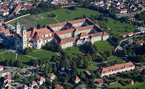
Ottobeuren Abbey Carsten Steger · CC BY-SA 4.0

Climate of Landkreis Unterallgäu
Best months for sightseeingBest months for sightseeing: June–September.
This month · November
A cold month
Day 6° · Night -1° · Rain 77 mm
- Hottest month
- July (day 22°)
- Coldest month
- January (night -4°)
- Wettest month
- June (135 mm)
- Driest month
- January (56 mm)
Bars: average monthly low and high temperature. Below: precipitation. Monthly averages for 1970–2000 at about 18 km resolution, adjusted for elevation. Highlighted months are mild and relatively dry. Source: WorldClim 2.1 (CC BY 4.0).
Show values as a table
| Month | Jan | Feb | Mar | Apr | May | Jun | Jul | Aug | Sep | Oct | Nov | Dec |
|---|---|---|---|---|---|---|---|---|---|---|---|---|
| Average high (°C) | 2° | 4° | 8° | 12° | 17° | 20° | 22° | 22° | 18° | 12° | 6° | 3° |
| Average low (°C) | -4° | -4° | -1° | 2° | 7° | 10° | 12° | 11° | 8° | 4° | -1° | -3° |
| Precipitation (mm) | 56 | 58 | 62 | 82 | 101 | 135 | 119 | 123 | 88 | 70 | 77 | 66 |
Other places to visit in this season: June July August September
How to get to Landkreis Unterallgäu
The nearest airport is Memmingen Allgau Airport (FMM), 15 km to the southwest as the crow flies. The nearest large city is Ulm, 49 km to the northwest.
Airports
- Memmingen Allgau Airport (FMM) Memmingen 15 kmsouthwest
- Bodensee Airport Friedrichshafen (FDH) Friedrichshafen 80 kmsouthwest
- Sankt Gallen Altenrhein Airport (ACH) St. Gallen 90 kmsouthwest
Nearby large cities
- Ulm Population: 120.5K 49 kmnorthwest
- Augsburg Population: 301.1K 50 kmnortheast
- Munich Population: 1.5M 87 kmeast
- Reutlingen Population: 112.6K 101 kmnorthwest
- Ingolstadt Population: 120.7K 108 kmnortheast
Straight-line distances; road distances are longer. Airport data: OurAirports.
Day trips from Landkreis Unterallgäu
Within 100 km: 701 historic and cultural sites, 3,780 natural sites, 1,189 lakes, rivers and coasts.
0–25 km286 places
- Waldsee Lake 15 kmSE
- Zweifelsberg Mountain 24 kmNE
- Zieglerberg Mountain 15 kmW
- Zeller Berg Mountain 22 kmSE
25–60 km1,607 places
- Sorgschrofen Mountain 57 kmS
- Schönkahler Mountain 59 kmS
- Aggentstein Mountain 59 kmS
- Pirschling Mountain 59 kmS
60–100 km3,777 places
- Bayerisches Oberland Mountain 85 kmSE
- Mainau Island 99 kmSW
- Schloss Hirschberg am Haarsee Historic site 67 kmSE
- elf-pavlik's tent Historic site 92 kmE
Straight-line distances.
Landkreis Unterallgäu and similar cities
Side by side with cities of similar size in the same country: population, elevation and climate.
| Measure | Landkreis Unterallgäu | Regensburg | Heidelberg | Neuss |
|---|---|---|---|---|
| Population | 147.4K | 151.4K | 143.3K | 152.5K |
| Elevation | 603 m | 341 m | 115 m | 44 m |
| Summer day (hottest month) | 22° | 24° | 24° | 24° |
| Winter night (coldest month) | -4° | -4° | 0° | 1° |
| Annual rainfall | 1,037 mm | 656 mm | 953 mm | 788 mm |
| Best months | Jun–Sep | May–Sep | May–Sep | Jun–Sep |
| Distance | — | 164 km | 196 km | 440 km |
Climate values are 1970–2000 monthly averages; straight-line distance.
Places in Landkreis Unterallgäu
52 places- 1 Bad Wörishofen 16.9K
- 2 Mindelheim 15.5K
- 3 Ottobeuren, Markt 8.5K
- 4 Türkheim, Markt 7.4K
- 5 Bad Grönenbach 5.8K
- 6 Babenhausen, Markt 5.7K
- 7 Markt Rettenbach, Markt 4K
- 8 Ettringen 3.5K
- 9 Legau, Markt 3.2K
- 10 Erkheim, Markt 3.1K
- 11 Buxheim 3.1K
- 12 Tussenhausen, Markt 3.1K
- 13 Memmingerberg 3K
- 14 Sontheim 2.7K
- 15 Pfaffenhausen, Markt 2.7K
- 16 Kirchheim i.Schw., Markt 2.5K
- 17 Boos 2.4K
- 18 Breitenbrunn 2.3K
- 19 Westerheim 2.3K
- 20 Dirlewang, Markt 2.3K
- 21 Woringen 2.1K
- 22 Markt Wald, Markt 2.1K
- 23 Wolfertschwenden 2.1K
- 24 Benningen 2.1K
- 25 Eppishausen 1.9K
- 26 Kettershausen 1.9K
- 27 Kammlach 1.9K
- 28 Heimertingen 1.8K
- 29 Kronburg 1.8K
- 30 Trunkelsberg 1.7K
- 31 Lachen 1.7K
- 32 Rammingen 1.6K
- 33 Niederrieden 1.5K
- 34 Amberg 1.5K
- 35 Stetten 1.5K
- 36 Wiedergeltingen 1.5K
- 37 Salgen 1.5K
- 38 Lauben 1.4K
- 39 Unteregg 1.4K
- 40 Holzgünz 1.4K
- 41 Kirchhaslach 1.3K
- 42 Hawangen 1.3K
- 43 Lautrach 1.3K
- 44 Egg a.d.Günz 1.2K
- 45 Oberrieden 1.2K
- 46 Fellheim 1.1K
- 47 Ungerhausen 1.1K
- 48 Oberschönegg 1K
- 49 Apfeltrach 974
- 50 Winterrieden 933
- 51 Pleß 893
- 52 Böhen 767
Bar: population relative to the most populous place in this list.
Nearby attractions & nature
Everything nearby-
Kammlach River, Bavaria2.4 km N
-
Hornholz Natural site, Bavaria4.3 km N
-
Auerbach River, Bavaria4.1 km E
-
Westernach River, Bavaria4.1 km E
-
Gutnachwald Natural site, Bavaria5.3 km NW
-
Saulengrain Wald Natural site, Bavaria5.9 km SE
-
Östlicher Hochfürst Natural site, Bavaria6.9 km S
-
Brunnerbach River, Bavaria6.4 km SE
Sources & licences
Data last updated: