Geiselbullach
Located in Olching, Landkreis Fürstenfeldbruck Coordinates: 48°13′40″ N 11°20′37″ E
- Elevation
- 498 m
- above sea level
- Local time
- UTC+01:00
- Europe/Berlin · UTC+01:00
- Airports
- MUC Munich Airport36 km
- FMM Memmingen Allgau Airport87 km
About Geiselbullach
Geiselbullach is a village. Location: Olching, Landkreis Fürstenfeldbruck. Elevation: 498 m. The best months to visit are June–September. The nearest airport is Munich Airport (36 km). Nearby sights include Fuchsberg and Feldgeding Filialkirche St. Augustinus.
Photos of Geiselbullach
-
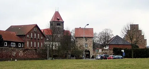
Early Camp Breitenau Armin Schönewolf · Public domain

Climate of Geiselbullach
Best months for sightseeingBest months for sightseeing: June–September.
This month · November
A cold month
Day 7° · Night 0° · Rain 67 mm
- Hottest month
- July (day 23°)
- Coldest month
- January (night -4°)
- Wettest month
- July (119 mm)
- Driest month
- January (47 mm)
Bars: average monthly low and high temperature. Below: precipitation. Monthly averages for 1970–2000 at about 18 km resolution, adjusted for elevation. Highlighted months are mild and relatively dry. Source: WorldClim 2.1 (CC BY 4.0).
Show values as a table
| Month | Jan | Feb | Mar | Apr | May | Jun | Jul | Aug | Sep | Oct | Nov | Dec |
|---|---|---|---|---|---|---|---|---|---|---|---|---|
| Average high (°C) | 2° | 4° | 9° | 13° | 18° | 21° | 23° | 23° | 19° | 13° | 7° | 4° |
| Average low (°C) | -4° | -3° | 0° | 3° | 7° | 10° | 12° | 12° | 9° | 4° | 0° | -2° |
| Precipitation (mm) | 47 | 48 | 55 | 67 | 91 | 115 | 119 | 105 | 79 | 63 | 67 | 58 |
Other places to visit in this season: June July August September
How to get to Geiselbullach
The nearest airport is Munich Airport (MUC), 36 km to the northeast as the crow flies. The nearest large city is Munich, 20 km to the southeast.
Airports
- Munich Airport (MUC) Munich 36 kmnortheast
- Memmingen Allgau Airport (FMM) Memmingen 87 kmwest
- Innsbruck Airport (INN) Innsbruck 108 kmsouth
Nearby large cities
- Munich Population: 1.5M 20 kmsoutheast
- Augsburg Population: 301.1K 37 kmnorthwest
- Ingolstadt Population: 120.7K 60 kmnorth
- Ulm Population: 120.5K 102 kmwest
- Regensburg Population: 151.4K 104 kmnortheast
Straight-line distances; road distances are longer. Airport data: OurAirports.
Day trips from Geiselbullach
Within 100 km: 629 historic and cultural sites, 2,827 natural sites, 969 lakes, rivers and coasts.
0–25 km261 places
- elf-pavlik's tent Historic site 22 kmE
- Wörthsee Lake 23 kmSW
- Weßlinger See Lake 19 kmS
- Zigeunerberg Mountain 22 kmSW
25–60 km916 places
- Schloss Hirschberg am Haarsee Historic site 47 kmS
- Loisach River 34 kmS
- Schwedeninsel Island 35 kmSW
- Roseninsel Island 32 kmS
60–100 km3,248 places
- Bayerisches Oberland Mountain 64 kmS
- Frauenchiemsee Island 90 kmSE
- Herreninsel Island 89 kmSE
- Zireiner See Lake 92 kmSE
Straight-line distances.
Nearby attractions & nature
Everything nearby-
Fuchsberg Mountain, Bergkirchen3.2 km NW
-
Feldgeding Filialkirche St. Augustinus Attraction, Bergkirchen3.1 km NE
-
Starzelbach River, Bavaria3.9 km SW
-
Early Camp Breitenau Historic site, Bergkirchen6.6 km NE
-
Lauterbach Filialkirche St. Jakobus Attraction, Bergkirchen5.3 km NW
-
Erlbach River, Bavaria5.2 km SE
Sources & licences
Data last updated: